Mount Claremont WA 6010
2,196 addresses · 103 streets
Curtin Electorate › Nedlands LGA › Mount Claremont · 8 km from Perth
📦 Thinking of moving here? Read the Mount Claremont moving guide

Living Here
Mount Claremont is a suburb of Western Australia, home to about 4,999 people, with a median age of 45. The typical household earns around $2,835 a week, with median rent near $420 a week. Most homes are houses. About 79% of households own their home and 16% rent. Most workers drive to work. Common community backgrounds include English, Australian, Scottish. On the ABS socio-economic scale it sits in decile 10 of 10 nationally — a relatively advantaged area.
Over time — Census 2001 → 2021
Dashed line: district figures for the Swanbourne - Mount Claremont statistical area (SA2), the smallest area the ABS published before 2011. Solid line: Mount Claremont itself.
Getting Around & Local Services
5 supermarkets
2 beaches
2 pharmacies
2 childcare & kindergartens
6 service stations
2 playgrounds
1 dog park
2 bakeries
1 butcher
2 beauty salons
2 electricians
2 plumbers
Getting around. Train station: Loch Street, 1.3 km south-east · Metro station: Perth Underground, 7.4 km east · Bus interchange: Elizabeth Quay Bus Station, 6.9 km east · Ferry wharf: Mends Street Jetty, 6.9 km east · Airport: Jandakot Airport, 17 km south-east.
Socio-economic Standing
Deciles from 1 (lowest) to 10 (highest), against all Australian suburbs. The overall figure weighs advantage and disadvantage together; economic resources counts income and housing, and education & jobs counts qualifications and occupation. They often differ. Source: ABS SEIFA 2021.
Tree cover
🌳 Tree canopy: 18.2% share of land under canopy · satellite map, 2020
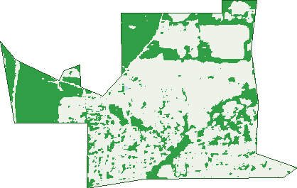
Green: 10 m cells where trees dominate, satellite 2021. Blue: water. The line is the suburb boundary.
| Canopy share, 1 m canopy height map, 2020 | 18.2% |
|---|---|
| Land with trees, 10 m satellite map, 2021 | 31.8% |
Demographics
Unemployment 3.7% · Labour-force participation 61.5%
Population by age in Mount Claremont
| 0-4 | 215 |
|---|---|
| 5-14 | 705 |
| 15-19 | 397 |
| 20-24 | 276 |
| 25-34 | 354 |
| 35-44 | 511 |
| 45-54 | 761 |
| 55-64 | 657 |
| 65-74 | 572 |
| 75-84 | 365 |
| 85+ | 181 |
Dwelling types in Mount Claremont
| House | 1,380 |
|---|---|
| Townhouse | 327 |
| Apartment | 71 |
| Other | 0 |
Households by weekly income in Mount Claremont
| <$650 | 282 |
|---|---|
| $650-1,499 | 278 |
| $1,500-2,999 | 286 |
| $3,000+ | 802 |
Top ancestries in Mount Claremont
| English | 2,017 |
|---|---|
| Australian | 1,550 |
| Scottish | 627 |
| Irish | 577 |
| Other | 534 |
| Chinese | 359 |
Housing tenure in Mount Claremont
| Owned | 753 |
|---|---|
| Mortgage | 636 |
| Rented | 290 |
| Other | 81 |
Cars per household in Mount Claremont
| 0 | 80 |
|---|---|
| 1 | 555 |
| 2 | 766 |
| 3 | 254 |
| 4+ | 109 |
Commute to work in Mount Claremont
| Car | 1,450 |
|---|---|
| Train | 65 |
| Bus | 114 |
| Tram/ferry | 0 |
| Walked | 25 |
| Bicycle | 49 |
| Home | 348 |
Top countries of birth in Mount Claremont
| England | 363 |
|---|---|
| South Africa | 156 |
| China | 107 |
| Malaysia | 101 |
| India | 71 |
| Scotland | 65 |
Languages used at home in Mount Claremont
| Mandarin | 159 |
|---|---|
| Cantonese | 57 |
| German | 40 |
| Italian | 33 |
| Hindi | 27 |
| Persian | 27 |
Birds & Wildlife Nearby
102,814 bird observations recorded near Mount Claremont — most often seen:
- Pacific Black Duck (5,368)
- Willie Wagtail (5,290)
- Australian Magpie (5,036)
- Red Wattlebird (5,007)
- Australian Raven (4,974)
- Rainbow Lorikeet (4,499)
- South-western Australian Magpie (4,179)
- Black Swan (3,782)
- Magpie-lark (3,541)
- Eurasian Coot (3,436)
- Western Red Wattlebird (3,407)
- Australian White Ibis (3,330)
- Singing Honeyeater (3,257)
Show all 30 birds recorded near Mount Claremont
- Grey Teal (3,224)
- Western Australian Raven (3,172)
- Eastern Rainbow Lorikeet (3,140)
- Australian Shelduck (3,016)
- Galah (2,941)
- Dusky Moorhen (2,940)
- South-western Singing Honeyeater (2,900)
- Little Pied Cormorant (2,874)
- Australian Wood Duck (2,873)
- Laughing Kookaburra (2,870)
- Laughing Turtle-dove (2,788)
- Brown Honeyeater (2,748)
- Little Corella (2,668)
- Australasian Grebe (2,554)
- Southern Willie Wagtail (2,516)
- Crested Tern (2,246)
- Western Brown Honeyeater (2,238)
Sightings reported by observers, not a survey, so the counts show what people record rather than what lives here. Source: Atlas of Living Australia.
Nearby Suburbs
The closest suburbs to Mount Claremont:
- Karrakatta (1.4 km)
- Claremont (1.9 km)
- Swanbourne (1.9 km)
- Nedlands (2.8 km)
- Shenton Park (3 km)
- Daglish (3.1 km)
- Floreat (3.1 km)
- Jolimont (3.5 km)
Embed this suburb
Add this free Mount Claremont stat card to your own site — just copy the code:
Preview:
Cite this page
Quoting these figures? Copy the credit line:
Keep an eye on Mount Claremont
One email when this data meaningfully changes — new census figures, prices, rankings. No spam, unsubscribe anytime.
Streets
- Abbey Gardens (16)
- Acacia Lane (4)
- Adderley Street (82)
- Agonis Lane (1)
- Alfred Road (131)
- Arenga Court (43)
- Ashbridge Retreat (10)
- Asquith Street (20)
- Banksia Drive (1)
- Barnsley Road (17)
- Barrow Court (4)
- Beecham Road (18)
- Bentley Close (23)
- Biara Gardens (45)
- Blenheim Lane (11)
- Brahea Place (5)
- Brockway Road (24)
- Bromilow Green (19)
- Brooklands Way (3)
- Burnettia Lane (32)
- Caladenia Parade (32)
- Camelia Avenue (17)
- Cavendish Rise (4)
- Charles Lane (4)
- Chessington Gardens (22)
- Cleland Street (13)
- Cobea Court (12)
- Cochram Court (10)
- Dorset Cove (7)
- Dryandra Way (6)
- Earls Court (10)
- Endell Ridge (4)
- Erica Avenue (33)
- Finch Way (8)
- Finchley Rise (8)
- Finsbury Grove (13)
- Fortview Road (40)
- Gainsford Lane (9)
- Godetia Gardens (22)
- Grainger Drive (27)
- Greenberry Close (13)
- Grove End Ridge (22)
- Grove Hill (7)
- Gulli Court (9)
- Haldane Street (39)
- Hamilton Gardens (6)
- Heritage Lane (1)
- Houston Place (12)
- Jacaranda Avenue (21)
- Jarrah Lane (22)
- John Xxiii Avenue (8)
- Jubaea Gardens (29)
- Kennedia Lane (9)
- Kings Row (8)
- Kurren Court (12)
- Lambeth Mews (10)
- Landon Way (22)
- Langtry View (7)
- Lantana Avenue (48)
- Lisle Street (130)
- Lisson Close (7)
- Lobelia Street (24)
- Lovegrove Close (25)
- Maida Place (28)
- Mayfair Street (85)
- Mcclemans Road (8)
- Mcgillivray Road (5)
- Mckenna Glen (17)
- Mimosa Avenue (25)
- Montgomery Avenue (16)
- Mooro Drive (86)
- Nandina Avenue (30)
- New Court Green (8)
- Newark Spur (5)
- Norfolk Rise (4)
- Northwick Parade (2)
- Olearia Lane (4)
- Oxford Court (8)
- Pimelea Crescent (8)
- Pine Tree Lane (15)
- Primula Place (13)
- Prince Albert Court (9)
- Queens Grove (9)
- Quintilian Road (43)
- Rawley Gardens (6)
- Regents Boulevard (1)
- Rochdale Road (119)
- Shannon Rise (9)
- St Johns Wood Boulevard (90)
- Stephenson Avenue (3)
- Strickland Street (98)
- Stubbs Terrace (1)
- Teslin Road (16)
- The Lodge (5)
- The Marlows (12)
- Towerhill Place (7)
- Townsend Dale (11)
- Traylen Grove (9)
- Van Kleef Circuit (21)
- Waraba Place (7)
- Whitney Crescent (7)
- Wollaston Road (8)
- Zamia Street (37)