Claremont WA 6010
6,458 addresses · 111 streets
Curtin Electorate › Claremont LGA › Claremont · 8 km from Perth
📦 Thinking of moving here? Read the Claremont moving guide

Living Here
Claremont is a suburb of Western Australia, home to about 9,248 people, with a median age of 44. The typical household earns around $2,068 a week, with median rent near $460 a week. Most homes are houses. About 64% of households own their home and 33% rent. Most workers drive to work. Common community backgrounds include English, Australian, Irish. On the ABS socio-economic scale it sits in decile 10 of 10 nationally — a relatively advantaged area.
Over time — Census 2001 → 2021
Dashed line: district figures for the Claremont (WA) statistical area (SA2), the smallest area the ABS published before 2011. Solid line: Claremont itself.
Getting Around & Local Services
7 supermarkets
2 pharmacies
4 doctors & medical clinics
3 childcare & kindergartens
5 service stations
1 dog park
1 butcher
1 beauty salon
3 mechanics
2 electricians
2 plumbers
Getting around. Train station: Claremont, 150 m north · Bus interchange: Elizabeth Quay Bus Station, 7.5 km north-east · Ferry wharf: East Street Ferry Jetty, 7 km south · Airport: Jandakot Airport, 15.4 km south-east.
Socio-economic Standing
Deciles from 1 (lowest) to 10 (highest), against all Australian suburbs. The overall figure weighs advantage and disadvantage together; economic resources counts income and housing, and education & jobs counts qualifications and occupation. They often differ. Source: ABS SEIFA 2021.
Tree cover
🌳 Tree canopy: 12.9% share of land under canopy · satellite map, 2020
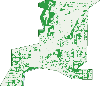
Green: 10 m cells where trees dominate, satellite 2021. Blue: water. The line is the suburb boundary.
| Canopy share, 1 m canopy height map, 2020 | 12.9% |
|---|---|
| Land with trees, 10 m satellite map, 2021 | 17.9% |
Demographics
Unemployment 4.6% · Labour-force participation 57.6%
Population by age in Claremont
| 0-4 | 355 |
|---|---|
| 5-14 | 955 |
| 15-19 | 628 |
| 20-24 | 602 |
| 25-34 | 1,123 |
| 35-44 | 970 |
| 45-54 | 1,150 |
| 55-64 | 1,061 |
| 65-74 | 1,032 |
| 75-84 | 916 |
| 85+ | 452 |
Dwelling types in Claremont
| House | 1,483 |
|---|---|
| Townhouse | 991 |
| Apartment | 1,316 |
| Other | 0 |
Households by weekly income in Claremont
| <$650 | 569 |
|---|---|
| $650-1,499 | 772 |
| $1,500-2,999 | 894 |
| $3,000+ | 1,282 |
Top ancestries in Claremont
| English | 4,009 |
|---|---|
| Australian | 2,695 |
| Irish | 1,113 |
| Scottish | 1,090 |
| Other | 993 |
| Chinese | 646 |
Housing tenure in Claremont
| Owned | 1,510 |
|---|---|
| Mortgage | 886 |
| Rented | 1,240 |
| Other | 113 |
Cars per household in Claremont
| 0 | 249 |
|---|---|
| 1 | 1,702 |
| 2 | 1,344 |
| 3 | 318 |
| 4+ | 139 |
Commute to work in Claremont
| Car | 2,406 |
|---|---|
| Train | 282 |
| Bus | 176 |
| Tram/ferry | 0 |
| Walked | 141 |
| Bicycle | 96 |
| Home | 571 |
Top countries of birth in Claremont
| England | 796 |
|---|---|
| China | 255 |
| South Africa | 192 |
| New Zealand | 144 |
| Singapore | 118 |
| Malaysia | 112 |
Languages used at home in Claremont
| Mandarin | 332 |
|---|---|
| Japanese | 92 |
| Spanish | 88 |
| French | 72 |
| Cantonese | 69 |
| Italian | 62 |
Birds & Wildlife Nearby
73,502 bird observations recorded near Claremont — most often seen:
- Willie Wagtail (3,926)
- Australian Magpie (3,834)
- Pacific Black Duck (3,690)
- Australian Raven (3,251)
- South-western Australian Magpie (3,204)
- Red Wattlebird (3,126)
- Black Swan (3,097)
- Rainbow Lorikeet (2,926)
- Western Red Wattlebird (2,852)
- Magpie-lark (2,659)
- Eastern Rainbow Lorikeet (2,630)
- Western Australian Raven (2,588)
- South-western Singing Honeyeater (2,389)
Show all 30 birds recorded near Claremont
- Little Pied Cormorant (2,355)
- Crested Tern (2,246)
- Singing Honeyeater (2,200)
- Laughing Turtle-dove (2,189)
- Silver Gull (2,123)
- Grey Teal (2,075)
- Australian Shelduck (2,037)
- Eurasian Coot (1,993)
- Little Corella (1,937)
- Galah (1,926)
- Southern Willie Wagtail (1,920)
- Australian White Ibis (1,793)
- Twenty-eight Parrot (1,749)
- Western Brown Honeyeater (1,747)
- Laughing Kookaburra (1,731)
- Brown Honeyeater (1,679)
- Dusky Moorhen (1,630)
Sightings reported by observers, not a survey, so the counts show what people record rather than what lives here. Source: Atlas of Living Australia.
Nearby Suburbs
The closest suburbs to Claremont:
- Swanbourne (1.4 km)
- Mount Claremont (1.9 km)
- Dalkeith (2.2 km)
- Peppermint Grove (2.4 km)
- Nedlands (2.4 km)
- Cottesloe (2.5 km)
- Karrakatta (2.5 km)
- Crawley (3.5 km)
Embed this suburb
Add this free Claremont stat card to your own site — just copy the code:
Preview:
Cite this page
Quoting these figures? Copy the credit line:
Keep an eye on Claremont
One email when this data meaningfully changes — new census figures, prices, rankings. No spam, unsubscribe anytime.
Streets
- Agett Road (35)
- Airlie Street (401)
- Albert Street (117)
- Alexandra Avenue (15)
- Alfred Road (104)
- Anstey Street (85)
- Ashton Avenue (51)
- Aston Place (6)
- Avion Way (1)
- Barcoo Avenue (1)
- Barnfield Road (67)
- Bay Road (85)
- Bay View Terrace (218)
- Bernard Street (36)
- Bindaring Parade (95)
- Bovell Lane (49)
- Brae Road (7)
- Brockway Road (14)
- Brown Street (50)
- Caxton Road (13)
- Chancellor Street (11)
- Chatsworth Terrace (40)
- Chester Road (33)
- Claremont Crescent (20)
- Cliff Road (21)
- Cliff Way (27)
- College Road (56)
- Congdon Street (16)
- Corry Lynn Road (15)
- Davies Road (484)
- Dean Street (137)
- Dunbar Road (27)
- Elliott Road (28)
- Evelyn Road (12)
- First Avenue (90)
- Freshwater Close (26)
- Freshwater Parade (171)
- George Avenue (14)
- Goldsmith Road (38)
- Goldsworthy Road (65)
- Grange Street (43)
- Grant Street (12)
- Graylands Road (184)
- Gugeri Street (156)
- Hammond Road (39)
- Harvey Lane (6)
- Henshaw Lane (6)
- Hillside Avenue (8)
- Jenkins Avenue (1)
- Jetty Road (2)
- John Street (17)
- Judge Avenue (13)
- King Street (18)
- Kingsmill Street (14)
- Koeppe Road (14)
- Kott Terrace (3)
- Kyle Way (89)
- Lakeway Street (21)
- Langsford Street (29)
- Lapsley Road (32)
- Leura Avenue (16)
- Links Court (12)
- Loch Street (48)
- Loton Road (7)
- Mary Street (34)
- Melville Street (32)
- Melvista Avenue (21)
- Mengler Avenue (93)
- Minderup Close (9)
- Mofflin Avenue (38)
- Motteram Avenue (13)
- Mount Street (38)
- O'beirne Street (1)
- Osborne Parade (44)
- Park Lane (25)
- Parker Road (3)
- Parry Street (32)
- Pennell Road (17)
- Princess Road (67)
- Prospect Place (7)
- Prospect Street (13)
- Queen Street (20)
- Queenslea Drive (62)
- Railway Street (39)
- Renown Avenue (11)
- Reserve Street (29)
- Richardson Avenue (86)
- Riley Road (55)
- Scott Street (6)
- Second Avenue (181)
- Senate Street (38)
- Shenton Place (7)
- Shenton Road (170)
- Smith Street (26)
- St Quentin Avenue (316)
- Stevens Street (1)
- Stirling Highway (632)
- Stirling Road (75)
- Stone Road (4)
- Stubbs Terrace (13)
- Tapper Lane (8)
- The Cedus (22)
- Thomson Road (33)
- Tiger Way (139)
- Vaucluse Avenue (29)
- Victoria Avenue (304)
- Walter Street (43)
- Warden Street (16)
- Warwick Street (7)
- Wilson Street (17)
- Windsor Street (11)