Floreat WA 6014
3,572 addresses · 118 streets
Curtin Electorate › Cambridge LGA › Floreat · 7 km from Perth
📦 Thinking of moving here? Read the Floreat moving guide

Living Here
Floreat is a suburb of Western Australia, home to about 8,621 people, with a median age of 42. The typical household earns around $3,570 a week, with median rent near $600 a week. Most homes are houses. About 87% of households own their home and 12% rent. Most workers drive to work. Common community backgrounds include English, Australian, Irish. On the ABS socio-economic scale it sits in decile 10 of 10 nationally — a relatively advantaged area.
Over time — Census 2001 → 2021
Dashed line: district figures for the Floreat statistical area (SA2), the smallest area the ABS published before 2011. Solid line: Floreat itself.
Getting Around & Local Services
1 beach
35 hospitals
4 childcare & kindergartens
7 service stations
1 playground
1 dog park
1 butcher
2 plumbers
Getting around. Train station: Daglish, 2.3 km south-east · Metro station: Perth Underground, 6.2 km east · Bus interchange: Elizabeth Quay Bus Station, 6 km east · Ferry wharf: Gondolas on the Swan, 6.2 km east · Airport: Perth Airport, 15.9 km east.
Socio-economic Standing
Deciles from 1 (lowest) to 10 (highest), against all Australian suburbs. The overall figure weighs advantage and disadvantage together; economic resources counts income and housing, and education & jobs counts qualifications and occupation. They often differ. Source: ABS SEIFA 2021.
Tree cover
🌳 Tree canopy: 16.8% share of land under canopy · satellite map, 2020
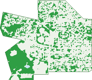
Green: 10 m cells where trees dominate, satellite 2021. Blue: water. The line is the suburb boundary.
| Canopy share, 1 m canopy height map, 2020 | 16.8% |
|---|---|
| Land with trees, 10 m satellite map, 2021 | 27.3% |
Demographics
Unemployment 3.9% · Labour-force participation 68.1%
Population by age in Floreat
| 0-4 | 412 |
|---|---|
| 5-14 | 1,474 |
| 15-19 | 729 |
| 20-24 | 436 |
| 25-34 | 533 |
| 35-44 | 1,032 |
| 45-54 | 1,435 |
| 55-64 | 1,219 |
| 65-74 | 767 |
| 75-84 | 408 |
| 85+ | 172 |
Dwelling types in Floreat
| House | 2,558 |
|---|---|
| Townhouse | 77 |
| Apartment | 214 |
| Other | 0 |
Households by weekly income in Floreat
| <$650 | 232 |
|---|---|
| $650-1,499 | 375 |
| $1,500-2,999 | 523 |
| $3,000+ | 1,501 |
Top ancestries in Floreat
| English | 3,436 |
|---|---|
| Australian | 3,008 |
| Irish | 1,135 |
| Scottish | 990 |
| Other | 850 |
| Italian | 574 |
Housing tenure in Floreat
| Owned | 1,300 |
|---|---|
| Mortgage | 1,152 |
| Rented | 347 |
| Other | 35 |
Cars per household in Floreat
| 0 | 51 |
|---|---|
| 1 | 743 |
| 2 | 1,342 |
| 3 | 473 |
| 4+ | 232 |
Commute to work in Floreat
| Car | 2,753 |
|---|---|
| Train | 27 |
| Bus | 257 |
| Tram/ferry | 0 |
| Walked | 68 |
| Bicycle | 113 |
| Home | 572 |
Top countries of birth in Floreat
| England | 591 |
|---|---|
| South Africa | 180 |
| China | 142 |
| Malaysia | 124 |
| Scotland | 99 |
| New Zealand | 98 |
Languages used at home in Floreat
| Mandarin | 227 |
|---|---|
| Italian | 79 |
| Cantonese | 59 |
| Japanese | 54 |
| Greek | 48 |
| French | 45 |
Birds & Wildlife Nearby
235,744 bird observations recorded near Floreat — most often seen:
- Pacific Black Duck (12,159)
- Willie Wagtail (11,341)
- Australian Raven (11,026)
- Eurasian Coot (10,744)
- Red Wattlebird (10,697)
- Australian White Ibis (10,292)
- Rainbow Lorikeet (10,253)
- Dusky Moorhen (9,957)
- Grey Teal (8,910)
- Black Swan (8,780)
- Australasian Grebe (8,631)
- Australasian Purple Swamphen (8,445)
- Singing Honeyeater (8,194)
Show all 30 birds recorded near Floreat
- Australian Shelduck (7,752)
- Australian Magpie (7,686)
- Magpie-lark (7,546)
- Australian Wood Duck (7,276)
- Little Pied Cormorant (6,636)
- Brown Honeyeater (6,619)
- Little Corella (6,412)
- Welcome Swallow (6,143)
- South-western Australian Magpie (6,117)
- Great Egret (6,045)
- Laughing Turtle-dove (6,035)
- Little Black Cormorant (5,543)
- Silvereye (5,458)
- Great Crested Grebe (5,439)
- Australian Pelican (5,238)
- Galah (5,221)
- Australian Reed Warbler (5,149)
Sightings reported by observers, not a survey, so the counts show what people record rather than what lives here. Source: Atlas of Living Australia.
Nearby Suburbs
The closest suburbs to Floreat:
- Churchlands (1.7 km)
- Jolimont (1.8 km)
- Daglish (2 km)
- Wembley (2 km)
- Herdsman (2.3 km)
- Karrakatta (2.7 km)
- Shenton Park (2.8 km)
- Subiaco (3 km)
Embed this suburb
Add this free Floreat stat card to your own site — just copy the code:
Preview:
Cite this page
Quoting these figures? Copy the credit line:
Keep an eye on Floreat
One email when this data meaningfully changes — new census figures, prices, rankings. No spam, unsubscribe anytime.
Streets
- Alderbury Street (145)
- Alyth Road (13)
- Arbordale Street (24)
- Athletes Parade (15)
- Athlone Road (32)
- Ayr Street (3)
- Bantry Road (5)
- Benwee Road (5)
- Berkeley Crescent (51)
- Birkdale Street (47)
- Bold Park Drive (1)
- Bournville Street (18)
- Boxing Lane (5)
- Brockway Road (1)
- Brookdale Street (40)
- Burvill Drive (74)
- Caithness Road (14)
- Callan Road (19)
- Cambridge Street (170)
- Cameron Green (16)
- Cargen Crescent (3)
- Champion Crescent (24)
- Chandler Avenue E (18)
- Chandler Avenue W (7)
- Clanmel Road (32)
- Comrie Street (1)
- Cork Road (1)
- Crail Street (4)
- Crieff Street (4)
- Cromarty Road (22)
- Crosby Street (20)
- Destiny Lane (29)
- Donegal Road (54)
- Draper Street (7)
- Dumfries Road (42)
- Dunblane Road (25)
- Dundalk Road (11)
- Dunkeld Street (14)
- Dynevor Rise (29)
- East Lorne Street (7)
- Edwards Green (14)
- Elphin Street (23)
- Equality Lane (11)
- Evandale Street (130)
- Everton Street (11)
- Ferndale Street (19)
- Finishline View (103)
- Floreat Avenue (9)
- Fox Green (10)
- Glamis Place (4)
- Glengariff Drive (85)
- Glenties Road (13)
- Grandstand Lane (19)
- Grantham Street (73)
- Grasby Street (4)
- Grovedale Road (43)
- Gunn Street (2)
- Highbury Street (21)
- Hornsey Road (27)
- Howson Approach (12)
- Howtree Place (101)
- Hurdles Drive (11)
- Javelin Lane (18)
- Katrine Street (12)
- Kenmore Crescent (30)
- Kildare Road (23)
- Kilkenny Road (18)
- Kincardine Crescent (35)
- Kinross Crescent (30)
- Kintyre Crescent (31)
- Kirkdale Avenue (33)
- Kirwan Street (107)
- Lichendale Street (13)
- Lifford Road (16)
- Linden Gardens (44)
- Lissadell Street (43)
- Lothian Street (7)
- Louth Road (3)
- Mead Grove (16)
- Meagher Drive (35)
- Moray Avenue (45)
- Moss Vale (12)
- Newry Street (90)
- North Banff Road (22)
- Oakdale Street (33)
- Oceanic Drive (73)
- Orrel Avenue (48)
- Pearson Place (13)
- Pearson Street (10)
- Peebles Road (58)
- Perry Lakes Drive (1)
- Rannoch Street (5)
- Relay Lane (8)
- Roscommon Road (33)
- Rosedale Street (38)
- Salvado Road (178)
- Selby Street (34)
- Seymour Avenue (21)
- Shann Street (39)
- Shannon Street (21)
- Silver Lane (1)
- South Banff Road (19)
- Stadium Drive (79)
- Steeplechase Green (7)
- Stephenson Avenue (1)
- Sunnyside Road (9)
- The Boulevard (105)
- Thurles Road (2)
- Tomlinson Boulevard (103)
- Tralee Road (7)
- Tullow Road (5)
- Turriff Road (24)
- Ulster Road (18)
- Underwood Avenue (5)
- Village Mews (4)
- West Lorne Street (15)
- Whitfeld Street (43)
- Winmarley Street (32)