Waurn Ponds VIC 3216
1,988 addresses · 105 streets
Corangamite Electorate › Greater Geelong LGA › Waurn Ponds · 73 km from Melbourne
📦 Thinking of moving here? Read the Waurn Ponds moving guide

Living Here
Waurn Ponds is a suburb of Victoria, home to about 4,956 people, with a median age of 27. The typical household earns around $2,286 a week, with median rent near $430 a week. Most homes are houses. About 78% of households own their home and 21% rent. Most workers drive to work. Common community backgrounds include English, Australian, Scottish. On the ABS socio-economic scale it sits in decile 9 of 10 nationally — a relatively advantaged area. The median house sells for about $775,500.
Over time — Census 2001 → 2021
Dashed line: district figures for the Grovedale statistical area (SA2), the smallest area the ABS published before 2011. Solid line: Waurn Ponds itself.
Getting Around & Local Services
5 supermarkets
3 pharmacies
3 doctors & medical clinics
3 dentists
3 physiotherapists
3 childcare & kindergartens
7 service stations
1 playground
1 bakery
2 hairdressers
1 electrician
1 plumber
Getting around. Train station: Waurn Ponds, 750 m south-east · Airport: Avalon Airport, 24.6 km north-east.
Sport & Recreation
5 facilities recorded in Waurn Ponds.
- Deakin University Oval Cricket
- Fernwood - Waurn Ponds Fitness / Gymnasium Workouts
- Snap Fitness Waurn Ponds Fitness / Gymnasium Workouts
- Waurn Ponds East Tennis Club Tennis (Outdoor)
- Waurn Ponds Tennis Club Tennis (Outdoor)
Socio-economic Standing
Deciles from 1 (lowest) to 10 (highest), against all Australian suburbs. The overall figure weighs advantage and disadvantage together; economic resources counts income and housing, and education & jobs counts qualifications and occupation. They often differ. Source: ABS SEIFA 2021.
Median Sale Prices
Median of recorded sales in the period, not a valuation. Source: Victorian Property Sales Report, Land Use Victoria.
Tree cover
🌳 Tree canopy: 5.9% share of land under canopy · satellite map, 2020
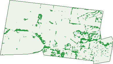
Green: 10 m cells where trees dominate, satellite 2021. Blue: water. The line is the suburb boundary.
| Canopy share, 1 m canopy height map, 2020 | 5.9% |
|---|---|
| Land with trees, 10 m satellite map, 2021 | 8.5% |
Demographics
Unemployment 6.3% · Labour-force participation 69.1%
Population by age in Waurn Ponds
| 0-4 | 195 |
|---|---|
| 5-14 | 606 |
| 15-19 | 642 |
| 20-24 | 816 |
| 25-34 | 601 |
| 35-44 | 522 |
| 45-54 | 662 |
| 55-64 | 422 |
| 65-74 | 304 |
| 75-84 | 154 |
| 85+ | 27 |
Dwelling types in Waurn Ponds
| House | 1,261 |
|---|---|
| Townhouse | 31 |
| Apartment | 0 |
| Other | 0 |
Households by weekly income in Waurn Ponds
| <$650 | 107 |
|---|---|
| $650-1,499 | 272 |
| $1,500-2,999 | 406 |
| $3,000+ | 403 |
Top ancestries in Waurn Ponds
| English | 1,888 |
|---|---|
| Australian | 1,882 |
| Scottish | 571 |
| Irish | 557 |
| Other | 392 |
| Ancestry NS | 230 |
Housing tenure in Waurn Ponds
| Owned | 443 |
|---|---|
| Mortgage | 562 |
| Rented | 272 |
| Other | 7 |
Cars per household in Waurn Ponds
| 0 | 11 |
|---|---|
| 1 | 305 |
| 2 | 556 |
| 3 | 236 |
| 4+ | 174 |
Commute to work in Waurn Ponds
| Car | 1,660 |
|---|---|
| Train | 21 |
| Bus | 45 |
| Tram/ferry | 0 |
| Walked | 32 |
| Bicycle | 8 |
| Home | 435 |
Top countries of birth in Waurn Ponds
| India | 197 |
|---|---|
| England | 146 |
| China | 67 |
| Sri Lanka | 67 |
| New Zealand | 40 |
| Philippines | 34 |
Languages used at home in Waurn Ponds
| Mandarin | 103 |
|---|---|
| Sinhalese | 58 |
| Hindi | 54 |
| Punjabi | 36 |
| Malayalam | 32 |
| Tamil | 27 |
Birds & Wildlife Nearby
66,303 bird observations recorded near Waurn Ponds — most often seen:
- Red Wattlebird (6,899)
- Southern Victoria Australian Magpie (5,128)
- Rainbow Lorikeet (4,740)
- Little Raven (4,300)
- Pied Currawong (4,207)
- Eurasian Blackbird (3,934)
- Grey Butcherbird (3,526)
- New Holland Honeyeater (3,472)
- Magpie-lark (3,353)
- Spotted Turtle-dove (2,960)
- Australian Magpie (2,542)
- Common Starling (2,185)
- House Sparrow (2,138)
Show all 30 birds recorded near Waurn Ponds
- Common Myna (1,846)
- Eastern Red Wattlebird (1,699)
- Welcome Swallow (1,468)
- Spotted Pardalote (1,353)
- Sulphur-crested Cockatoo (1,091)
- Silvereye (1,012)
- Eastern New Holland Honeyeater (976)
- Crested Pigeon (830)
- Willie Wagtail (778)
- Yellow-tailed Black-cockatoo (778)
- Galah (762)
- Pacific Black Duck (760)
- Coastal Spotted Pardalote (759)
- Straw-necked Ibis (748)
- Eastern Asian Spotted Dove (744)
- Superb Fairy-wren (663)
- Masked Lapwing (652)
Sightings reported by observers, not a survey, so the counts show what people record rather than what lives here. Source: Atlas of Living Australia.
Nearby Suburbs
The closest suburbs to Waurn Ponds:
- Mount Duneed (2.8 km)
- Grovedale (2.8 km)
- Wandana Heights (3.8 km)
- Highton (4.1 km)
- Belmont (4.8 km)
- Marshall (5 km)
- Ceres (5.3 km)
- Charlemont (5.4 km)
Embed this suburb
Add this free Waurn Ponds stat card to your own site — just copy the code:
Preview:
Cite this page
Quoting these figures? Copy the credit line:
Keep an eye on Waurn Ponds
One email when this data meaningfully changes — new census figures, prices, rankings. No spam, unsubscribe anytime.
Streets
- Acacia Lane (25)
- Alva Court (15)
- Anglesea Road (6)
- Ash Court (8)
- Banrock Court (36)
- Banyan Court (9)
- Barossa Court (21)
- Beaujolais Place (8)
- Belperroud Road (5)
- Blackheath Mews (45)
- Bodega Street (14)
- Bogans Lane (1)
- Bollinger Street (8)
- Bordeaux Drive (17)
- Bourbon Way (38)
- Brentwood Way (15)
- Brumor Place (6)
- Burgundy Drive (52)
- Cabernet Court (16)
- Capri Grove (3)
- Capri Way (2)
- Carradale Street (8)
- Cassis Court (3)
- Catania Close (16)
- Chablis Court (28)
- Champagne Court (6)
- Chandon Court (16)
- Chardonnay Court (19)
- Chenin Mews (27)
- Chianti Place (8)
- Cochranes Road (35)
- Colac Road (31)
- Cork Place (4)
- Cortona Place (13)
- Cottonwood Way (21)
- Danaher Avenue (22)
- Deakinwood Court (6)
- Delgany Mews (14)
- Drayton Road (4)
- Eden Court (20)
- Elm Court (6)
- Epworth Place (25)
- Ghazeepore Road (103)
- Grange Park Drive (46)
- Grenache Drive (22)
- Hams Road (35)
- Honeys Road (3)
- Hoop Court (7)
- Huon Court (17)
- Ironbark Street (74)
- Jarrahwood Place (10)
- Jasmin Court (7)
- Katelyn Court (14)
- Kia Court (5)
- Kingsbury Lane (3)
- Kinsmead Street (17)
- Lemins Road (34)
- Lexia Place (6)
- Luggs Road (8)
- Malbec Loop (17)
- Maple Place (9)
- Marcus Road (1)
- Marendaz Road (7)
- Mclaren Court (6)
- Mcpherson Road (27)
- Merlot Street (32)
- Merribell Drive (6)
- Mica Court (6)
- Moet Court (6)
- Monterey Drive (57)
- Moyston Lane (6)
- Mumm Street (10)
- Muscat Place (16)
- Oakwood Crescent (61)
- Oldham Road (6)
- Paget Road (5)
- Peppertree Rise (29)
- Pettavel Road (2)
- Pigdons Road (37)
- Pine Court (9)
- Pinot Street (18)
- Platina Avenue (14)
- Primrose Drive (16)
- Princes Highway (3)
- Rene Street (9)
- Reservoir Road (11)
- Resolute Drive (16)
- Reward Court (7)
- Roaming Creek Court (8)
- Rossack Drive (65)
- Semillion Place (20)
- Shiraz Drive (37)
- Sian Circuit (27)
- Sugargum Drive (29)
- Tannin Way (37)
- The Vineyard (25)
- Tigerlilly Lane (8)
- Traminer Court (10)
- Tree Street (14)
- Tuscan Court (24)
- Tussock Place (2)
- Vintage Court (18)
- Viogner Place (23)
- Waurn Ponds Drive (43)
- Willesden Drive (56)