Charlemont VIC 3217
4,440 addresses · 187 streets
Corangamite Electorate › Greater Geelong LGA › Charlemont · 69 km from Melbourne
📦 Thinking of moving here? Read the Charlemont moving guide

Living Here
Charlemont is a suburb of Victoria, home to about 2,612 people, with a median age of 29. The typical household earns around $2,102 a week, with median rent near $415 a week. Most homes are houses. About 71% of households own their home and 29% rent. Most workers drive to work. Common community backgrounds include Australian, English, Irish. On the ABS socio-economic scale it sits in decile 8 of 10 nationally — a relatively advantaged area. The median house sells for about $612,000.
Over time — Census 2001 → 2021
Dashed line: district figures for the Grovedale statistical area (SA2), the smallest area the ABS published before 2011. Solid line: Charlemont itself.
Getting Around & Local Services
4 doctors & medical clinics
1 dentist
2 physiotherapists
2 post offices
2 playgrounds
1 dog park
3 bakeries
2 hairdressers
1 beauty salon
1 electrician
1 plumber
Getting around. Train station: Marshall, 1.8 km north-west · Ferry wharf: Port Phillip Ferries (Geelong-Docklands), 7.9 km north · Airport: Avalon Airport, 22.1 km north-east.
Socio-economic Standing
Deciles from 1 (lowest) to 10 (highest), against all Australian suburbs. The overall figure weighs advantage and disadvantage together; economic resources counts income and housing, and education & jobs counts qualifications and occupation. They often differ. Source: ABS SEIFA 2021.
Median Sale Prices
Median of recorded sales in the period, not a valuation. Source: Victorian Property Sales Report, Land Use Victoria.
Tree cover
🌳 Tree canopy: 4.3% share of land under canopy · satellite map, 2020
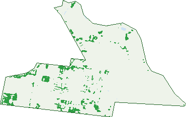
Green: 10 m cells where trees dominate, satellite 2021. Blue: water. The line is the suburb boundary.
| Canopy share, 1 m canopy height map, 2020 | 4.3% |
|---|---|
| Land with trees, 10 m satellite map, 2021 | 6.5% |
Demographics
Unemployment 2.3% · Labour-force participation 78.6%
Population by age in Charlemont
| 0-4 | 260 |
|---|---|
| 5-14 | 251 |
| 15-19 | 102 |
| 20-24 | 314 |
| 25-34 | 779 |
| 35-44 | 377 |
| 45-54 | 169 |
| 55-64 | 176 |
| 65-74 | 81 |
| 75-84 | 55 |
| 85+ | 41 |
Dwelling types in Charlemont
| House | 934 |
|---|---|
| Townhouse | 17 |
| Apartment | 0 |
| Other | 0 |
Households by weekly income in Charlemont
| <$650 | 37 |
|---|---|
| $650-1,499 | 226 |
| $1,500-2,999 | 447 |
| $3,000+ | 181 |
Top ancestries in Charlemont
| Australian | 1,015 |
|---|---|
| English | 892 |
| Irish | 309 |
| Other | 271 |
| Scottish | 250 |
| Indian | 173 |
Housing tenure in Charlemont
| Owned | 99 |
|---|---|
| Mortgage | 573 |
| Rented | 271 |
| Other | 5 |
Cars per household in Charlemont
| 0 | 10 |
|---|---|
| 1 | 290 |
| 2 | 460 |
| 3 | 117 |
| 4+ | 66 |
Commute to work in Charlemont
| Car | 1,101 |
|---|---|
| Train | 11 |
| Bus | 5 |
| Tram/ferry | 0 |
| Walked | 0 |
| Bicycle | 0 |
| Home | 258 |
Top countries of birth in Charlemont
| India | 145 |
|---|---|
| England | 40 |
| Philippines | 30 |
| New Zealand | 23 |
| Nepal | 18 |
| Malaysia | 12 |
Languages used at home in Charlemont
| Punjabi | 57 |
|---|---|
| Malayalam | 49 |
| Gujarati | 33 |
| Nepali | 27 |
| Serbian | 18 |
| Mandarin | 17 |
Birds & Wildlife Nearby
78,696 bird observations recorded near Charlemont — most often seen:
- Magpie-lark (4,425)
- Little Raven (4,165)
- Welcome Swallow (3,815)
- Red Wattlebird (3,749)
- Pacific Black Duck (3,337)
- Superb Fairy-wren (3,243)
- Common Starling (3,188)
- Australasian Purple Swamphen (3,114)
- Australian White Ibis (2,962)
- Chestnut Teal (2,812)
- Australian Magpie (2,651)
- Black Swan (2,641)
- House Sparrow (2,586)
Show all 30 birds recorded near Charlemont
- Common Myna (2,497)
- Willie Wagtail (2,481)
- Southern Victoria Australian Magpie (2,372)
- Eurasian Coot (2,353)
- Straw-necked Ibis (2,350)
- White-faced Heron (2,265)
- Rainbow Lorikeet (2,225)
- New Holland Honeyeater (2,167)
- White-plumed Honeyeater (2,145)
- Eurasian Blackbird (2,119)
- Swamp Harrier (2,109)
- Dusky Moorhen (1,954)
- Masked Lapwing (1,893)
- Crested Pigeon (1,855)
- Spotted Turtle-dove (1,824)
- Silver Gull (1,717)
- Grey Teal (1,682)
Sightings reported by observers, not a survey, so the counts show what people record rather than what lives here. Source: Atlas of Living Australia.
Nearby Suburbs
The closest suburbs to Charlemont:
- Marshall (2.2 km)
- Armstrong Creek (2.3 km)
- Grovedale (2.9 km)
- Mount Duneed (3.5 km)
- Breakwater (3.7 km)
- St Albans Park (3.9 km)
- Belmont (4.5 km)
- Whittington (4.8 km)
Embed this suburb
Add this free Charlemont stat card to your own site — just copy the code:
Preview:
Cite this page
Quoting these figures? Copy the credit line:
Keep an eye on Charlemont
One email when this data meaningfully changes — new census figures, prices, rankings. No spam, unsubscribe anytime.
Streets
- Abbott Street (25)
- Albany Way (25)
- Almon Street (7)
- Amber Avenue (23)
- Ambitious Avenue (30)
- Annatta Crescent (18)
- Anvil Street (21)
- Arnold Circuit (53)
- Arya Road (14)
- Ashcroft Drive (14)
- Ashfield Drive (58)
- Audrey Street (22)
- Baelish Drive (24)
- Baratheon Road (17)
- Barbra Drive (99)
- Barwarre Road (15)
- Barwon Heads Road (36)
- Batten Road (37)
- Beaumont Avenue (65)
- Beeston Avenue (16)
- Bligh Street (17)
- Boundary Road (37)
- Bramley Avenue (115)
- Brearleys Lane (5)
- Burgenstein Drive (20)
- Burgenstein Road (12)
- Burgenstien Drive (20)
- Burwood Avenue (3)
- Carlton Avenue (12)
- Codrington Street (16)
- Collingtree Street (1)
- Crestview Street (12)
- Delos Way (10)
- Devereux Way (47)
- Diego Place (3)
- Divine Road (20)
- Donegal Drive (1)
- Dunken Street (15)
- Dutch Street (10)
- Edwin Street (9)
- Elbert Street (27)
- Endurance Grove (13)
- Epicurus Street (9)
- Eunomus Way (12)
- Everton Crescent (31)
- Fall Street (12)
- Farmington Street (2)
- Flannery Circuit (62)
- Forge Road (1)
- Forge Way (3)
- Frangapini Avenue (19)
- Frangipani Avenue (19)
- Frost Drive (62)
- Frost Road (10)
- Galanthus Street (17)
- Genovesi Street (13)
- Geometry Drive (61)
- Gilliland Street (2)
- Gilroy Crescent (62)
- Giovanni Drive (56)
- Gravity Drive (31)
- Greyjoy Road (111)
- Hackamore Street (9)
- Hadley Street (32)
- Harriott Road (40)
- Hart Loop (5)
- Hart Street (21)
- Havant Circuit (34)
- Havant Street (34)
- Hendrina Street (5)
- Hillsborough Walk (19)
- Hilltop Drive (33)
- Horomidis Street (20)
- Horseshoe Bend Road (96)
- Hypotenuse Avenue (8)
- Ida Street (22)
- Italianate Street (30)
- Jendes Lane (5)
- Jimmy Street (20)
- Kashmir Road (19)
- Kennard Grove (24)
- Kimblewick Avenue (7)
- Kindee Way (9)
- Kings Lane (1)
- Kneebone Place (3)
- Kramer Way (9)
- Kynaston Circuit (13)
- Lannaster Road (74)
- Lannister Road (32)
- Larkspur Way (14)
- Lillrose Drive (55)
- Limestone Street (14)
- Literature Walk (17)
- Lyanna Way (5)
- Macomb Way (8)
- Maidstone Way (12)
- Marlee Drive (16)
- Mattnick Boulevard (38)
- Meereen Street (47)
- Milesi Street (25)
- Milligan Circuit (15)
- Minimalist Place (4)
- Modular Street (24)
- Mollyan Avenue (43)
- Munro Drive (77)
- Munro Loop (19)
- Naughtin Circuit (20)
- Norcott Road (6)
- Norton Parade (17)
- Oakdale Street (29)
- Oleary Walk (9)
- Olenna Street (19)
- Oriley Street (10)
- Orland Circuit (43)
- Orland Loop (39)
- Orti Way (8)
- Paley Street (28)
- Palladian Avenue (24)
- Palladian Drive (24)
- Palustris Street (22)
- Parkes Avenue (9)
- Parkfield Boulevard (18)
- Pavilion Court (6)
- Petrus Way (12)
- Pigeon Street (33)
- Precinct Road (98)
- Puddy Way (7)
- Pythais Way (10)
- Rafferty Lane (12)
- Rechenberg Boulevard (57)
- Rechenberg Street (6)
- Reins Street (19)
- Reserve Road (32)
- Revival Street (16)
- Rodgers Court (15)
- Rotunno Avenue (18)
- Rotunno Drive (80)
- Ryder Street (41)
- Samwell Street (19)
- Sandor Terrace (17)
- Scoparia Street (22)
- Scottsdale Street (30)
- Scullin Road (33)
- Snow Street (6)
- Sparrovale Road (63)
- Springleaf Way (4)
- Spur Place (4)
- Stannis Street (21)
- Stoke Street (18)
- Stones Road (11)
- Stones Street (26)
- Structural Place (4)
- Studden Way (8)
- Summertime Avenue (14)
- Swanburra Drive (17)
- Swift Road (22)
- Swift Street (21)
- Symmetry Place (2)
- Tabor Street (20)
- Tannery Road (38)
- Tasha Street (32)
- Taylors Circuit (30)
- Theorem Avenue (36)
- Theorem Drive (36)
- Torquay Road (14)
- Trent Crescent (26)
- Triangle Loop (14)
- Tully Street (8)
- Tyson Loop (18)
- Tywin Street (14)
- Ulric Place (2)
- Valrose Road (33)
- Vandelay Avenue (23)
- Vault Way (6)
- Wall Street (3)
- Walter Street (27)
- Weymouth Rise (6)
- Wilby Walk (9)
- Winter Fell Road (26)
- Winterfell Road (26)
- Winton Street (12)
- Wise Street (4)
- Woodyard Drive (3)
- Woolscour Lane (1)
- Worn Road (67)
- Wylie Street (39)
- Yildiz Street (22)