Belmont VIC 3216
9,342 addresses · 232 streets
Corio Electorate › Greater Geelong LGA › Belmont · 68 km from Melbourne
📦 Thinking of moving here? Read the Belmont moving guide

Living Here
An established suburb of Geelong south of the Barwon River, Belmont is a residential and shopping hub. Households average 2.3 people and the median age is 37. Median household income is $1,517 a week, with rent around $350.
Belmont is a suburb of Victoria, home to about 15,066 people, with a median age of 37. The typical household earns around $1,517 a week, with median rent near $350 a week. Most homes are houses. About 63% of households own their home and 36% rent. Most workers drive to work. Common community backgrounds include English, Australian, Irish. On the ABS socio-economic scale it sits in decile 6 of 10 nationally — a mid-range area. The median house sells for about $700,000.
Over time — Census 2001 → 2021
Dashed line: district figures for the Belmont statistical area (SA2), the smallest area the ABS published before 2011. Solid line: Belmont itself.
Getting Around & Local Services
11 childcare & kindergartens
1 dog park
2 butchers
1 electrician
1 plumber
Getting around. Train station: Marshall, 2.7 km south-east · Ferry wharf: Port Phillip Ferries (Geelong-Docklands), 4.4 km north-east · Airport: Avalon Airport, 19.9 km north-east.
Sport & Recreation
12 facilities recorded in Belmont, the first 10 below.
- Barwon Valley Activity Centre Soccer (Indoor Soccer / Futsal), Volleyball
- Belmont Common North Australian Rules Football, Cricket
- Belmont Criterium Facility Cycling
- Francis Street Reserve Croquet, Tennis (Outdoor)
- Geelong Lawn Tennis Club Lawn Bowls, Tennis (Outdoor)
- Geelong RSL Club Lawn Bowls
- Goodlife Geelong Fitness / Gymnasium Workouts
- McDonald Reserve Australian Rules Football, Cricket, Netball
- Pioneer Reserve (Geelong baseball centre) Baseball, Tennis (Outdoor)
- South Barwon reserve Australian Rules Football, BMX, Cricket
Socio-economic Standing
Deciles from 1 (lowest) to 10 (highest), against all Australian suburbs. The overall figure weighs advantage and disadvantage together; economic resources counts income and housing, and education & jobs counts qualifications and occupation. They often differ. Source: ABS SEIFA 2021.
Median Sale Prices
Median of recorded sales in the period, not a valuation. Source: Victorian Property Sales Report, Land Use Victoria.
Tree cover
🌳 Tree canopy: 11.2% share of land under canopy · satellite map, 2020
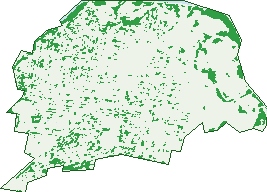
Green: 10 m cells where trees dominate, satellite 2021. Blue: water. The line is the suburb boundary.
| Canopy share, 1 m canopy height map, 2020 | 11.2% |
|---|---|
| Land with trees, 10 m satellite map, 2021 | 11.4% |
Demographics
Unemployment 4.6% · Labour-force participation 63%
Population by age in Belmont
| 0-4 | 943 |
|---|---|
| 5-14 | 1,646 |
| 15-19 | 736 |
| 20-24 | 1,077 |
| 25-34 | 2,621 |
| 35-44 | 1,970 |
| 45-54 | 1,697 |
| 55-64 | 1,547 |
| 65-74 | 1,412 |
| 75-84 | 894 |
| 85+ | 528 |
Dwelling types in Belmont
| House | 4,821 |
|---|---|
| Townhouse | 1,126 |
| Apartment | 53 |
| Other | 177 |
Households by weekly income in Belmont
| <$650 | 1,171 |
|---|---|
| $650-1,499 | 1,747 |
| $1,500-2,999 | 1,901 |
| $3,000+ | 1,059 |
Top ancestries in Belmont
| English | 6,064 |
|---|---|
| Australian | 5,421 |
| Irish | 2,274 |
| Scottish | 1,894 |
| Other | 1,329 |
| German | 744 |
Housing tenure in Belmont
| Owned | 1,960 |
|---|---|
| Mortgage | 1,934 |
| Rented | 2,179 |
| Other | 61 |
Cars per household in Belmont
| 0 | 419 |
|---|---|
| 1 | 2,591 |
| 2 | 2,303 |
| 3 | 572 |
| 4+ | 242 |
Commute to work in Belmont
| Car | 4,565 |
|---|---|
| Train | 25 |
| Bus | 94 |
| Tram/ferry | 0 |
| Walked | 161 |
| Bicycle | 56 |
| Home | 1,458 |
Top countries of birth in Belmont
| India | 428 |
|---|---|
| England | 373 |
| New Zealand | 171 |
| China | 134 |
| Scotland | 91 |
| Philippines | 86 |
Languages used at home in Belmont
| Mandarin | 166 |
|---|---|
| Italian | 102 |
| Hindi | 101 |
| Malayalam | 78 |
| Spanish | 66 |
| Punjabi | 61 |
Birds & Wildlife Nearby
290,419 bird observations recorded near Belmont — most often seen:
- Red Wattlebird (24,928)
- Rainbow Lorikeet (19,922)
- Little Raven (18,923)
- Magpie-lark (16,616)
- Southern Victoria Australian Magpie (16,393)
- Eurasian Blackbird (16,215)
- Spotted Turtle-dove (15,618)
- New Holland Honeyeater (14,446)
- Common Myna (13,050)
- Pied Currawong (12,894)
- House Sparrow (12,535)
- Common Starling (12,334)
- Grey Butcherbird (10,417)
Show all 30 birds recorded near Belmont
- Australian Magpie (8,111)
- Silvereye (7,252)
- Sulphur-crested Cockatoo (7,015)
- Welcome Swallow (6,923)
- Silver Gull (5,745)
- Pacific Black Duck (5,546)
- Willie Wagtail (4,956)
- Dusky Moorhen (4,780)
- Superb Fairy-wren (4,477)
- Chestnut Teal (4,103)
- Eurasian Coot (4,086)
- Crested Pigeon (4,060)
- Galah (4,017)
- White-plumed Honeyeater (3,893)
- Spotted Pardalote (3,776)
- Australian White Ibis (3,703)
- Australasian Purple Swamphen (3,685)
Sightings reported by observers, not a survey, so the counts show what people record rather than what lives here. Source: Atlas of Living Australia.
Nearby Suburbs
The closest suburbs to Belmont:
- Highton (2.3 km)
- Marshall (2.4 km)
- South Geelong (2.5 km)
- Grovedale (2.8 km)
- Newtown (2.8 km)
- Breakwater (3 km)
- Wandana Heights (3.2 km)
- Thomson (3.6 km)
Embed this suburb
Add this free Belmont stat card to your own site — just copy the code:
Preview:
Cite this page
Quoting these figures? Copy the credit line:
Keep an eye on Belmont
One email when this data meaningfully changes — new census figures, prices, rankings. No spam, unsubscribe anytime.
Streets
- Albert Terrace (37)
- Allitt Avenue (28)
- Alsop Street (17)
- Amundsen Street (30)
- Angus Street (10)
- Apaloosa Court (10)
- Apex Avenue (141)
- Araluen Parade (16)
- Arbour Grove (30)
- Argyle Street (23)
- Armagh Court (5)
- Armitage Court (13)
- Arthur Street (19)
- Ashford Court (10)
- Autumn Street (52)
- Bailey Street (200)
- Banks Court (4)
- Barrabool Road (410)
- Barwon Heads Road (44)
- Batman Close (17)
- Belle Vue Avenue (10)
- Belmont Arcade (6)
- Belmont Centreway (12)
- Belmont Square (8)
- Belmont Street (21)
- Berramongo Court (11)
- Birnam Court (7)
- Bohan Grove (6)
- Boolarong Drive (22)
- Brahman Close (9)
- Breakwater Road (11)
- Bridge View Street (11)
- Brocka Avenue (29)
- Cambra Road (98)
- Cambridge Street (43)
- Camdell Court (18)
- Carlisle Street (2)
- Carr Street (30)
- Charles Street (15)
- Charolais Court (12)
- Cheryl Crescent (43)
- Church Street (44)
- Clarke Avenue (91)
- Clyde Street (2)
- Clydesdale Crescent (20)
- Colac Grove (53)
- Colac Road (8)
- Collins Street (20)
- Corio Street (82)
- Cornish Avenue (35)
- Corriedale Court (15)
- Cranmere Avenue (35)
- Crows Road (36)
- Culbin Avenue (40)
- Curtis Street (16)
- Cyril Court (8)
- Dargai Road (8)
- Davis Street (88)
- De Vere Court (12)
- Dean Street (10)
- Deed Street (18)
- Digby Avenue (57)
- Discovery Lane (5)
- Donald Street (27)
- Dorothy Avenue (67)
- Dorr Court (13)
- Downshire Road (13)
- Dudley Street (40)
- East View Parade (15)
- Edith Court (13)
- Edmill Court (10)
- Eldridge Place (16)
- Elizabeth Street (22)
- Elsvern Avenue (37)
- Emerald Court (13)
- Englewood Court (10)
- Eton Road (67)
- Evans Street (47)
- Exeter Grove (19)
- Fairbrae Avenue (71)
- Fairfield Avenue (26)
- Fairview Street (55)
- Fife Court (3)
- Finchfield Lane (19)
- Findlay Grove (13)
- Fisher Avenue (24)
- Francis Street (354)
- Frank Street (9)
- Friesian Court (12)
- Garyth Court (6)
- George Street (41)
- Gill Street (15)
- Glen Avenue (4)
- Glenara Court (13)
- Glenbrae Court (17)
- Glenys Court (11)
- Glyn Street (27)
- Grayling Street (32)
- Gundog Lane (7)
- Hagan Court (19)
- Harrow Close (9)
- Hawthorn Avenue (18)
- Hazel Street (21)
- Helena Street (13)
- Henry Street (34)
- Herbert Street (40)
- Herd Road (51)
- Hereford Drive (39)
- High Street (557)
- Highmont Drive (50)
- Hill Street (51)
- Iona Avenue (94)
- Jacaranda Place (18)
- Jacobs Street (39)
- James Street (97)
- Jarrah Place (9)
- Jersey Court (13)
- Johnson Street (17)
- Kardinia Street (38)
- Kenneth Street (16)
- Kent Court (5)
- Kidman Avenue (75)
- Killara Court (9)
- King Street (21)
- Kinnon Avenue (33)
- Kinross Street (9)
- Kinsley Court (6)
- Kiteroa Street (5)
- Kossecks Place (13)
- Kyle Avenue (18)
- Laura Avenue (147)
- Learmouth Street (56)
- Leonard Street (39)
- Lloyd Street (45)
- Mack Court (21)
- Marjorie Avenue (76)
- Matilda Court (33)
- Maxwell Avenue (11)
- Mcdonald Street (15)
- Mckenzie Street (36)
- Mckeown Lane (5)
- Mernda Parade (57)
- Merralyn Street (10)
- Milford Place (13)
- Mitchell Street (45)
- Morris Street (49)
- Mount Pleasant Road (253)
- Mt Pleasant Road (216)
- Nagle Drive (57)
- Neil Street (12)
- Nicholson Court (3)
- North Avenue (6)
- Nott Street (29)
- Oberon Drive (87)
- Olwen Avenue (20)
- Oxford Street (45)
- Palamino Court (7)
- Park Street (33)
- Patern Street (1)
- Pavo Street (93)
- Peary Street (29)
- Perth Street (29)
- Pickett Crescent (19)
- Pilbara Court (6)
- Pine Tree Court (8)
- Polwarth Crescent (51)
- Poplar Court (16)
- Prospect Avenue (29)
- Quarry Close (2)
- Queen Street (35)
- Redgum Court (11)
- Regent Street (98)
- Reynolds Road (47)
- Rigo Street (18)
- Riverglen Court (15)
- Riverview Terrace (63)
- Roberts Road (56)
- Roger Street (5)
- Roslyn Road (397)
- Rotherham Street (35)
- Rowan Court (23)
- Royd Grange Court (4)
- Rugby Street (56)
- Sanglen Terrace (59)
- Savage Street (10)
- Scott Street (52)
- Seaview Parade (41)
- Settlement Road (195)
- Shackleton Street (75)
- Shara Court (10)
- Shetland Court (5)
- Short Street (5)
- Sommers Street (10)
- South Street (89)
- Southdown Crescent (43)
- Spring Street (46)
- Stephen Street (23)
- Stork Avenue (55)
- Sullivan Court (19)
- Summit Avenue (105)
- Taldra Court (6)
- Tanunda Grove (26)
- Tasman Avenue (42)
- Tegwen Street (11)
- Tettenhall Ridge (31)
- The Avenue (122)
- The Spinney (4)
- Thomas Street (30)
- Thomson Street (74)
- Tintinara Crescent (36)
- Tiverton Street (13)
- Torquay Road (164)
- Union Street (13)
- Uno Street (7)
- Ursa Street (26)
- Victoria Terrace (34)
- View Street (18)
- Violet Street (7)
- Vivian Street (22)
- Voce Court (16)
- Walker Street (5)
- Walpole Avenue (50)
- Watson Avenue (73)
- Waurn Park Court (28)
- Waurnvale Drive (62)
- White Street (19)
- William Street (3)
- Wimmera Street (27)
- Winter Street (30)
- Woolvet Avenue (31)
- Wyuna Parade (26)
- Yvonne Street (4)