Highton VIC 3216
10,604 addresses · 369 streets
Corio Electorate › Greater Geelong LGA › Highton · 70 km from Melbourne
📦 Thinking of moving here? Read the Highton moving guide

Living Here
An established, well-regarded suburb of Geelong on the Barwon River, Highton is family-oriented. Households average 2.6 people and the median age is 39. Median household income is $2,054 a week, with rent around $360.
Highton is a suburb of Victoria, home to about 20,736 people, with a median age of 39. The typical household earns around $2,054 a week, with median rent near $360 a week. Most homes are houses. About 77% of households own their home and 22% rent. Most workers drive to work. Common community backgrounds include English, Australian, Irish. On the ABS socio-economic scale it sits in decile 9 of 10 nationally — a relatively advantaged area. The median house sells for about $863,500.
Over time — Census 2001 → 2021
Dashed line: district figures for the Highton statistical area (SA2), the smallest area the ABS published before 2011. Solid line: Highton itself.
Getting Around & Local Services
1 dog park
2 butchers
1 electrician
1 plumber
Getting around. Train station: South Geelong, 4.4 km east · Ferry wharf: Port Phillip Ferries (Geelong-Docklands), 5.5 km north-east · Airport: Avalon Airport, 20.9 km north-east.
Sport & Recreation
5 facilities recorded in Highton.
- Deakin YMCA Geelong Badminton, Basketball, Fitness / Gymnasium Workouts, Netball (Indoor), Soccer (Indoor Soccer / Futsal), Squash / Racquetball, Tennis (Outdoor)
- Highton Reserve Australian Rules Football, Cricket, Lawn Bowls, Tennis (Outdoor)
- Leisurelink aquatic and recreation centre Fitness / Gymnasium Workouts, Swimming
- Queens Park Australian Rules Football, Cricket, Netball
- Queens Park Reserve Australian Rules Football, Cricket, Golf, Netball
Socio-economic Standing
Deciles from 1 (lowest) to 10 (highest), against all Australian suburbs. The overall figure weighs advantage and disadvantage together; economic resources counts income and housing, and education & jobs counts qualifications and occupation. They often differ. Source: ABS SEIFA 2021.
Median Sale Prices
Median of recorded sales in the period, not a valuation. Source: Victorian Property Sales Report, Land Use Victoria.
Tree cover
🌳 Tree canopy: 10.7% share of land under canopy · satellite map, 2020
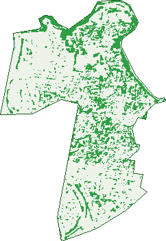
Green: 10 m cells where trees dominate, satellite 2021. Blue: water. The line is the suburb boundary.
| Canopy share, 1 m canopy height map, 2020 | 10.7% |
|---|---|
| Land with trees, 10 m satellite map, 2021 | 20.4% |
Demographics
Unemployment 3.5% · Labour-force participation 65.4%
Population by age in Highton
| 0-4 | 1,108 |
|---|---|
| 5-14 | 2,805 |
| 15-19 | 1,271 |
| 20-24 | 1,509 |
| 25-34 | 2,482 |
| 35-44 | 2,731 |
| 45-54 | 2,665 |
| 55-64 | 2,372 |
| 65-74 | 2,031 |
| 75-84 | 1,327 |
| 85+ | 435 |
Dwelling types in Highton
| House | 6,508 |
|---|---|
| Townhouse | 922 |
| Apartment | 18 |
| Other | 0 |
Households by weekly income in Highton
| <$650 | 977 |
|---|---|
| $650-1,499 | 1,679 |
| $1,500-2,999 | 2,163 |
| $3,000+ | 2,241 |
Top ancestries in Highton
| English | 7,964 |
|---|---|
| Australian | 7,129 |
| Irish | 2,833 |
| Scottish | 2,689 |
| Other | 1,984 |
| Italian | 973 |
Housing tenure in Highton
| Owned | 2,872 |
|---|---|
| Mortgage | 2,849 |
| Rented | 1,593 |
| Other | 82 |
Cars per household in Highton
| 0 | 252 |
|---|---|
| 1 | 2,203 |
| 2 | 3,462 |
| 3 | 943 |
| 4+ | 525 |
Commute to work in Highton
| Car | 6,333 |
|---|---|
| Train | 36 |
| Bus | 73 |
| Tram/ferry | 0 |
| Walked | 115 |
| Bicycle | 77 |
| Home | 2,469 |
Top countries of birth in Highton
| England | 701 |
|---|---|
| India | 505 |
| China | 314 |
| New Zealand | 233 |
| South Africa | 159 |
| Sri Lanka | 130 |
Languages used at home in Highton
| Mandarin | 390 |
|---|---|
| Italian | 164 |
| Arabic | 143 |
| Hindi | 126 |
| Punjabi | 119 |
| Sinhalese | 106 |
Birds & Wildlife Nearby
231,104 bird observations recorded near Highton — most often seen:
- Red Wattlebird (19,664)
- Rainbow Lorikeet (15,892)
- Little Raven (14,635)
- Southern Victoria Australian Magpie (12,943)
- Eurasian Blackbird (12,880)
- New Holland Honeyeater (12,866)
- Magpie-lark (12,231)
- Spotted Turtle-dove (12,057)
- Common Myna (11,194)
- House Sparrow (10,639)
- Common Starling (10,180)
- Pied Currawong (9,963)
- Grey Butcherbird (7,304)
Show all 30 birds recorded near Highton
- Australian Magpie (6,653)
- Silvereye (5,868)
- Welcome Swallow (5,543)
- Sulphur-crested Cockatoo (4,801)
- Pacific Black Duck (4,794)
- Dusky Moorhen (4,272)
- Superb Fairy-wren (4,137)
- Willie Wagtail (3,990)
- Eurasian Coot (3,639)
- Chestnut Teal (3,586)
- Australasian Purple Swamphen (3,527)
- White-plumed Honeyeater (3,234)
- Silver Gull (3,197)
- Crested Pigeon (2,945)
- Spotted Pardalote (2,907)
- Straw-necked Ibis (2,782)
- Australian White Ibis (2,781)
Sightings reported by observers, not a survey, so the counts show what people record rather than what lives here. Source: Atlas of Living Australia.
Nearby Suburbs
The closest suburbs to Highton:
- Wandana Heights (0.9 km)
- Belmont (2.3 km)
- Newtown (3.1 km)
- Ceres (3.5 km)
- Grovedale (3.7 km)
- Fyansford (4 km)
- Waurn Ponds (4.1 km)
- South Geelong (4.3 km)
Embed this suburb
Add this free Highton stat card to your own site — just copy the code:
Preview:
Cite this page
Quoting these figures? Copy the credit line:
Keep an eye on Highton
One email when this data meaningfully changes — new census figures, prices, rankings. No spam, unsubscribe anytime.
Streets
- Adelaide Street (18)
- Admiral Court (17)
- Aitkenside Avenue (18)
- Alamo Close (4)
- Amberley Court (18)
- Amelia Street (11)
- Amoore Avenue (28)
- Ande Court (15)
- Annmaree Road (10)
- Aringa Avenue (21)
- Arkana Avenue (29)
- Attunga Court (5)
- Augustine Drive (119)
- Avondale Avenue (6)
- Badenoch Court (7)
- Ballara Court (9)
- Balleroy Road (15)
- Barrabool Road (342)
- Barwon Boulevard (77)
- Basin Rise (81)
- Baum Crescent (26)
- Bayview Court (13)
- Belle Vue Arcade (15)
- Belle Vue Avenue (164)
- Belvedere Court (6)
- Bennett Street (18)
- Berry Court (4)
- Bevington Court (10)
- Bexley Court (7)
- Bilby Lane (5)
- Bilston Court (11)
- Binbrook Court (15)
- Blyton Court (8)
- Bonsey Road (57)
- Bounty Close (6)
- Bracken Court (4)
- Brassey Avenue (43)
- Brendan Court (7)
- Broughton Drive (125)
- Bruthen Road (24)
- Buchan Court (5)
- Buckley Falls Road (38)
- Bundoora Crescent (14)
- Burberry Court (10)
- Burdekin Road (39)
- Butler Court (5)
- Cahill Court (10)
- Cannes Court (17)
- Cara Road (69)
- Carina Way (27)
- Caroline Street (30)
- Carramar Court (12)
- Carroll Road (23)
- Caudry Street (10)
- Cedar Grove (52)
- Cedarville Close (20)
- Cedmar Avenue (22)
- Cemaloma Court (6)
- Chadree Court (5)
- Challambra Crescent (50)
- Chalon Court (7)
- Chancellor Place (14)
- Cheam Walk (17)
- Cholet Court (3)
- Clearview Court (10)
- Clearwater Grove (10)
- Clemont Street (10)
- Clifford Street (24)
- Clydesdale Way (69)
- Cobb Court (16)
- Cobden Street (18)
- Colac Road (121)
- Colden Place (14)
- Connemara Close (1)
- Conway Court (14)
- Coreen Close (2)
- Coronado Court (11)
- Cortland Drive (14)
- Cranwell Court (39)
- Crestmoor Drive (41)
- Cromwell Place (7)
- Culzean Crescent (53)
- Cumulus Avenue (25)
- Cuthbert Avenue (47)
- Daglish Avenue (10)
- Dale Place (7)
- Daly Boulevard (71)
- Dartmoor Drive (19)
- Denham Court (4)
- Desmond Street (12)
- Devon Park Drive (36)
- Donnington Court (8)
- Dougal Court (7)
- Dryden Way (106)
- Duggan Court (23)
- Dumfries Court (13)
- Dunsmore Road (31)
- East Kirkby Court (11)
- Elizabeth Street (38)
- Elliott Avenue (41)
- Elmsford Court (8)
- Elsvern Avenue (3)
- Esperence Crescent (38)
- Ettric Way (9)
- Evwick Crescent (26)
- Exmoor Close (26)
- Fenland Court (10)
- Ferndale Parade (49)
- Fernhill Drive (24)
- Ficinia Mews (73)
- Finningley Court (22)
- Fitzpatrick Court (9)
- Floreat Avenue (21)
- Fogarty Avenue (115)
- Foymount Crescent (32)
- Frayne Court (15)
- Frogmore Way (23)
- Fryers Road (64)
- Galloway Court (14)
- Gamston Court (10)
- Garvey Court (21)
- Giverny Close (13)
- Glastonbury Drive (134)
- Glen Lossie Way (8)
- Glenmire Street (14)
- Glenville Road (18)
- Granby Crescent (42)
- Grantham Drive (156)
- Greenwich Grange (8)
- Grenoble Court (5)
- Gretton Court (7)
- Greyfern Court (7)
- Gumtree Court (7)
- Gweneth Avenue (2)
- Gwyther Road (51)
- Haigh Court (11)
- Harrison Court (12)
- Harvell Court (14)
- Harvest Street (6)
- Hayes Court (15)
- Helena Street (20)
- Hemswell Court (22)
- Hendriks Court (16)
- Hewat Drive (46)
- Highett Road (47)
- Highland Way (81)
- Highpoint Crescent (40)
- Highrise Court (11)
- Highton Court (4)
- Hill Park Place (9)
- Hillary Court (14)
- Hillcrest Court (11)
- Holland Court (6)
- Homestead Court (4)
- Homewood Lane (37)
- Horizon Court (27)
- Huntly Close (13)
- Hutcheson Avenue (65)
- Idwall Court (15)
- Iona Avenue (11)
- Jalana Court (10)
- Jellindale Court (11)
- Jessica Way (38)
- Jewell Place (30)
- Jinjella Road (30)
- Karrakatta Grove (20)
- Kastor Street (4)
- Keating Court (8)
- Kelty Court (10)
- Kennedy Grove (15)
- Keram Crescent (14)
- Kerrins Court (9)
- Kindale Court (18)
- Kinther Court (7)
- Knollbrook Close (40)
- Konrads Crescent (47)
- Koop Close (9)
- Koorong Court (16)
- Kooyong Place (12)
- Kyeema Avenue (60)
- Lambhill Crescent (32)
- Landes Avenue (13)
- Landy Avenue (19)
- Lansbury Crescent (41)
- Lansell Drive (29)
- Larcombe Street (61)
- Lascelles Place (21)
- Leigh Road (96)
- Leilani Court (18)
- Lein Court (19)
- Lichen Grove (26)
- Lindholme Court (12)
- Linthwaite Close (9)
- Linton Lane (36)
- Lipizzaner Court (14)
- Lochgoin Mews (15)
- Lord Place (2)
- Lund Court (4)
- Lynch Court (7)
- Macken Court (8)
- Madigan Court (16)
- Maidie Street (27)
- Majestic Drive (60)
- Manche Court (7)
- Manor Crescent (24)
- Marcus Street (30)
- Marfell Court (9)
- Marlyn Court (10)
- Mason Court (4)
- Maus Street (21)
- Mawarra Court (14)
- Mcevoy Close (9)
- Mcrorie Street (5)
- Meadow Court (6)
- Melrose Avenue (18)
- Meltham Avenue (11)
- Mercia Close (16)
- Merino Court (5)
- Merrick Court (16)
- Merrigum Court (5)
- Mill Race Road (29)
- Miller Court (10)
- Molesworth Drive (53)
- Mont Dor Parade (14)
- Montague Street (72)
- Montpellier Drive (58)
- Montril Court (11)
- Montrose Place (56)
- Moore Court (9)
- Morena Street (38)
- Moreton Bay Drive (52)
- Morley Crescent (11)
- Morven Court (23)
- Mosman Way (36)
- Mount Pleasant Road (176)
- Mt Pleasant Road (151)
- Mulquiney Crescent (97)
- Murray Street (29)
- Napthine Way (5)
- Narrawong Avenue (23)
- Nedlands Drive (40)
- Nelson Avenue (35)
- Nevair Court (23)
- Nomad Lane (2)
- Norman Court (13)
- North Valley Road (158)
- Northam Avenue (36)
- Northbridge Road (22)
- Nunan Court (10)
- Oakbank Avenue (33)
- Oakhill Avenue (15)
- Oakview Court (15)
- Odriscol Court (20)
- Old Flour Mill Road (10)
- Orana Road (15)
- Orchardview Court (9)
- Oxbow Court (22)
- Palmerston Place (20)
- Parkland Court (6)
- Parkwood Drive (55)
- Patern Street (49)
- Pepperdine Way (45)
- Percy Jones Court (12)
- Pickering Circuit (74)
- Pigdons Road (89)
- Pinecrest Drive (37)
- Pinehill Court (7)
- Pinnacle Close (14)
- Pinoak Court (7)
- Pinto Way (22)
- Polo Place (9)
- Porter Avenue (53)
- Premier Court (14)
- Province Boulevard (103)
- Queens Park Road (28)
- Radstock Avenue (60)
- Rathmines Place (14)
- Regal Street (3)
- Reigate Road (109)
- Remony Avenue (33)
- Reston Court (7)
- Reynolds Road (6)
- Rice Court (8)
- Ridgeway Lane (14)
- Rivergum Drive (49)
- Rivington Court (18)
- Roncliffe Road (21)
- Rosetta Court (8)
- Roslyn Road (185)
- Rouen Street (13)
- Roycroft Avenue (16)
- Rudi Court (3)
- Sandtoft Court (9)
- Scampton Court (5)
- Scenic Road (108)
- Senior Court (20)
- Sheoak Court (6)
- Sherwood Court (7)
- Shetland Close (11)
- Shire Court (25)