St Albans Park VIC 3219
2,453 addresses · 94 streets
Corio Electorate › Greater Geelong LGA › St Albans Park · 65 km from Melbourne
📦 Thinking of moving here? Read the St Albans Park moving guide

Living Here
St Albans Park is a suburb of Victoria, home to about 4,942 people, with a median age of 46. The typical household earns around $1,317 a week, with median rent near $330 a week. Most homes are houses. About 74% of households own their home and 23% rent. Most workers drive to work. Common community backgrounds include English, Australian, Irish. On the ABS socio-economic scale it sits in decile 2 of 10 nationally — a more disadvantaged area. The median house sells for about $585,000.
Over time — Census 2001 → 2021
Dashed line: district figures for the Newcomb - Moolap statistical area (SA2), the smallest area the ABS published before 2011. Solid line: St Albans Park itself.
Getting Around & Local Services
3 supermarkets
2 pharmacies
4 doctors & medical clinics
3 childcare & kindergartens
1 post office
1 dog park
1 bakery
2 butchers
1 hairdresser
1 electrician
1 plumber
Getting around. Train station: Marshall, 3.5 km south-west · Ferry wharf: Port Phillip Ferries (Geelong-Docklands), 5.5 km north-west · Airport: Avalon Airport, 18.3 km north-east.
Socio-economic Standing
Deciles from 1 (lowest) to 10 (highest), against all Australian suburbs. The overall figure weighs advantage and disadvantage together; economic resources counts income and housing, and education & jobs counts qualifications and occupation. They often differ. Source: ABS SEIFA 2021.
Median Sale Prices
Median of recorded sales in the period, not a valuation. Source: Victorian Property Sales Report, Land Use Victoria.
Tree cover
🌳 Tree canopy: 6.7% share of land under canopy · satellite map, 2020
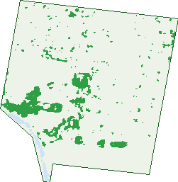
Green: 10 m cells where trees dominate, satellite 2021. Blue: water. The line is the suburb boundary.
| Canopy share, 1 m canopy height map, 2020 | 6.7% |
|---|---|
| Land with trees, 10 m satellite map, 2021 | 7.5% |
Demographics
Unemployment 4.5% · Labour-force participation 58.1%
Population by age in St Albans Park
| 0-4 | 221 |
|---|---|
| 5-14 | 477 |
| 15-19 | 300 |
| 20-24 | 293 |
| 25-34 | 618 |
| 35-44 | 481 |
| 45-54 | 675 |
| 55-64 | 687 |
| 65-74 | 627 |
| 75-84 | 392 |
| 85+ | 175 |
Dwelling types in St Albans Park
| House | 1,710 |
|---|---|
| Townhouse | 286 |
| Apartment | 0 |
| Other | 0 |
Households by weekly income in St Albans Park
| <$650 | 414 |
|---|---|
| $650-1,499 | 632 |
| $1,500-2,999 | 581 |
| $3,000+ | 225 |
Top ancestries in St Albans Park
| English | 2,146 |
|---|---|
| Australian | 2,051 |
| Irish | 602 |
| Scottish | 580 |
| Other | 306 |
| Italian | 252 |
Housing tenure in St Albans Park
| Owned | 697 |
|---|---|
| Mortgage | 752 |
| Rented | 456 |
| Other | 55 |
Cars per household in St Albans Park
| 0 | 125 |
|---|---|
| 1 | 719 |
| 2 | 711 |
| 3 | 244 |
| 4+ | 171 |
Commute to work in St Albans Park
| Car | 1,714 |
|---|---|
| Train | 6 |
| Bus | 14 |
| Tram/ferry | 0 |
| Walked | 18 |
| Bicycle | 17 |
| Home | 246 |
Top countries of birth in St Albans Park
| England | 161 |
|---|---|
| India | 43 |
| New Zealand | 37 |
| Scotland | 30 |
| Philippines | 28 |
| Netherlands | 27 |
Languages used at home in St Albans Park
| Italian | 33 |
|---|---|
| Punjabi | 24 |
| Mandarin | 16 |
| Arabic | 13 |
| Tagalog | 13 |
| Thai | 12 |
Birds & Wildlife Nearby
145,668 bird observations recorded near St Albans Park — most often seen:
- Red Wattlebird (9,742)
- Magpie-lark (9,521)
- Little Raven (9,440)
- Rainbow Lorikeet (6,435)
- Southern Victoria Australian Magpie (6,428)
- Common Starling (6,094)
- Spotted Turtle-dove (6,060)
- Silver Gull (5,896)
- Eurasian Blackbird (5,746)
- Welcome Swallow (5,405)
- Grey Butcherbird (4,917)
- House Sparrow (4,808)
- Australian White Ibis (4,537)
Show all 30 birds recorded near St Albans Park
- Common Myna (4,501)
- Superb Fairy-wren (4,305)
- Australian Magpie (4,157)
- Pacific Black Duck (4,104)
- Chestnut Teal (3,846)
- New Holland Honeyeater (3,778)
- Pied Currawong (3,691)
- Willie Wagtail (3,627)
- White-faced Heron (3,475)
- Masked Lapwing (3,462)
- Straw-necked Ibis (3,426)
- Australasian Purple Swamphen (3,295)
- Black Swan (3,250)
- Crested Pigeon (3,037)
- Galah (3,033)
- Little Pied Cormorant (2,890)
- Sulphur-crested Cockatoo (2,762)
Sightings reported by observers, not a survey, so the counts show what people record rather than what lives here. Source: Atlas of Living Australia.
Nearby Suburbs
The closest suburbs to St Albans Park:
- Whittington (1.1 km)
- Breakwater (1.8 km)
- Newcomb (2.3 km)
- Thomson (2.4 km)
- Moolap (2.7 km)
- Marshall (3.3 km)
- East Geelong (3.3 km)
- South Geelong (3.7 km)
Embed this suburb
Add this free St Albans Park stat card to your own site — just copy the code:
Preview:
Cite this page
Quoting these figures? Copy the credit line:
Keep an eye on St Albans Park
One email when this data meaningfully changes — new census figures, prices, rankings. No spam, unsubscribe anytime.
Streets
- Aitken Court (12)
- Alcott Road (18)
- Aldershot Road (41)
- Ardula Court (12)
- Belkan Court (19)
- Birchwood Drive (14)
- Boundary Road (35)
- Bradford Street (27)
- Bradshaw Court (12)
- Braeside Court (6)
- Brampton Place (6)
- Brodie Court (9)
- Bronte Court (19)
- Buckington Street (5)
- Carbine Drive (39)
- Carrick Court (8)
- Cedarwood Court (9)
- Chandos Court (52)
- Cleverdon Court (9)
- Cluny Court (8)
- Collins Street (27)
- Coonara Court (8)
- Cooper Drive (20)
- Coppards Road (22)
- Crozier Court (11)
- Dickens Drive (19)
- Doreimus Court (18)
- Dulcify Court (6)
- Dunbar Road (4)
- Durran Street (36)
- East End Crescent (50)
- Elizabeth Street (36)
- Ellstone Avenue (28)
- Enfield Drive (83)
- Filipi Drive (48)
- Freeman Court (7)
- Gandross Place (16)
- Gannet Court (9)
- Garnfield Place (12)
- Gatehouse Place (3)
- Glenae Court (6)
- Govett Crescent (61)
- Grafton Street (76)
- Homestead Drive (96)
- Jenna Court (22)
- Langer Drive (28)
- Lloyd Court (12)
- Lucy Court (24)
- Lymington Court (12)
- Malua Court (7)
- Mandela Court (23)
- Manikato Court (21)
- Maplewood Court (15)
- Mayfield Crescent (35)
- Mcgill Court (8)
- Meadenhall Drive (64)
- Mersey Court (11)
- Mervyn Court (19)
- Nada Close (9)
- Newhaven Avenue (42)
- Nivek Court (14)
- Oakwood Ridge (7)
- Ottoman Court (16)
- Paramount Crescent (38)
- Paratone Crescent (54)
- Pinder Court (34)
- Portland Avenue (2)
- Ranken Lane (5)
- Raymond Court (21)
- Rimfire Close (8)
- Riseborough Court (12)
- Roberts Court (9)
- Roseview Way (32)
- Saintly Way (4)
- Silk Street (1)
- Silverwood Court (14)
- Sirius Court (19)
- Skye Court (10)
- St Albans Street (64)
- St James Street (65)
- Strathmore Court (12)
- Tabess Court (20)
- Taminga Mews (9)
- Tantalla Court (8)
- Taras Court (12)
- Templeton Court (13)
- Townsend Road (217)
- Trenton Parade (31)
- Tresco Court (13)
- Wallace Court (6)
- Westmoreland Street (80)
- Wilsons Road (142)
- Woods Road (33)
- Zazzman Court (14)