Oakleigh VIC 3166
6,199 addresses · 102 streets
Hotham Electorate › Monash LGA › Oakleigh · 15 km from Melbourne
📦 Thinking of moving here? Read the Oakleigh moving guide

Living Here
Oakleigh is a suburb of Victoria, home to about 8,442 people, with a median age of 38. The typical household earns around $1,926 a week, with median rent near $410 a week. Most homes are houses. About 63% of households own their home and 35% rent. Most workers drive to work. Common community backgrounds include English, Australian, Greek. On the ABS socio-economic scale it sits in decile 9 of 10 nationally — a relatively advantaged area. The median house sells for about $1,311,000.
Over time — Census 2001 → 2021
Dashed line: district figures for the Oakleigh - Huntingdale statistical area (SA2), the smallest area the ABS published before 2011. Solid line: Oakleigh itself.
Getting Around & Local Services
20 childcare & kindergartens
Getting around. Train station: Oakleigh, 550 m west · Tram stop: Stop 68: Koornang Road, 3.5 km west · Bus interchange: Huntingdale Station, 1.3 km south-east · Airport: Moorabbin Airport, 8.7 km south.
Sport & Recreation
9 facilities recorded in Oakleigh.
- Caloola Reserve Cricket, Soccer
- Challenge Fitness Centre Fitness / Gymnasium Workouts, Karate
- Jack Edwards Reserve Soccer
- Oakleigh Bowls Club Lawn Bowls
- Oakleigh Indoor Sports Cricket (Indoor), Netball (Indoor), Soccer (Indoor Soccer / Futsal), Volleyball
- Oakleigh Recreation Centre Badminton, Basketball, Netball (Indoor), Soccer (Indoor Soccer / Futsal), Swimming, Tennis (Outdoor), Volleyball
- Scammell Reserve Australian Rules Football, Cricket, Lawn Bowls
- Scotchmans Run Reserve Baseball, Cricket
- Warrawee Park Australian Rules Football, Cricket
Socio-economic Standing
Deciles from 1 (lowest) to 10 (highest), against all Australian suburbs. The overall figure weighs advantage and disadvantage together; economic resources counts income and housing, and education & jobs counts qualifications and occupation. They often differ. Source: ABS SEIFA 2021.
Median Sale Prices
Median of recorded sales in the period, not a valuation. Source: Victorian Property Sales Report, Land Use Victoria.
Tree cover
🌳 Tree canopy: 9.2% share of land under canopy · satellite map, 2020
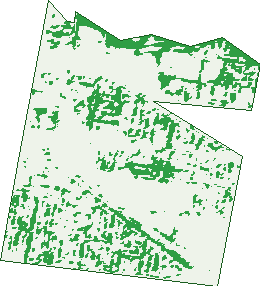
Green: 10 m cells where trees dominate, satellite 2021. Blue: water. The line is the suburb boundary.
| Canopy share, 1 m canopy height map, 2020 | 9.2% |
|---|---|
| Land with trees, 10 m satellite map, 2021 | 18.6% |
Demographics
Unemployment 5.3% · Labour-force participation 66.1%
Population by age in Oakleigh
| 0-4 | 414 |
|---|---|
| 5-14 | 814 |
| 15-19 | 421 |
| 20-24 | 712 |
| 25-34 | 1,438 |
| 35-44 | 1,158 |
| 45-54 | 1,175 |
| 55-64 | 978 |
| 65-74 | 649 |
| 75-84 | 414 |
| 85+ | 262 |
Dwelling types in Oakleigh
| House | 2,016 |
|---|---|
| Townhouse | 400 |
| Apartment | 837 |
| Other | 4 |
Households by weekly income in Oakleigh
| <$650 | 542 |
|---|---|
| $650-1,499 | 702 |
| $1,500-2,999 | 925 |
| $3,000+ | 927 |
Top ancestries in Oakleigh
| English | 1,769 |
|---|---|
| Australian | 1,623 |
| Greek | 1,375 |
| Other | 1,295 |
| Chinese | 916 |
| Irish | 723 |
Housing tenure in Oakleigh
| Owned | 1,023 |
|---|---|
| Mortgage | 1,019 |
| Rented | 1,125 |
| Other | 50 |
Cars per household in Oakleigh
| 0 | 352 |
|---|---|
| 1 | 1,356 |
| 2 | 1,065 |
| 3 | 281 |
| 4+ | 158 |
Commute to work in Oakleigh
| Car | 1,939 |
|---|---|
| Train | 152 |
| Bus | 54 |
| Tram/ferry | 4 |
| Walked | 89 |
| Bicycle | 31 |
| Home | 1,545 |
Top countries of birth in Oakleigh
| Greece | 508 |
|---|---|
| China | 470 |
| India | 360 |
| England | 183 |
| Italy | 137 |
| Vietnam | 101 |
Languages used at home in Oakleigh
| Greek | 1,125 |
|---|---|
| Mandarin | 570 |
| Italian | 171 |
| Cantonese | 130 |
| Vietnamese | 113 |
| Hindi | 98 |
Birds & Wildlife Nearby
318,318 bird observations recorded near Oakleigh — most often seen:
- Noisy Miner (22,354)
- Rainbow Lorikeet (22,056)
- Little Raven (21,731)
- Australian Magpie (21,466)
- Common Myna (18,413)
- Spotted Turtle-dove (17,858)
- Red Wattlebird (15,829)
- Magpie-lark (13,931)
- Eurasian Blackbird (13,241)
- Pacific Black Duck (11,178)
- Common Starling (10,163)
- Grey Butcherbird (9,777)
- Welcome Swallow (9,044)
Show all 30 birds recorded near Oakleigh
- Brown Thornbill (8,382)
- Dusky Moorhen (8,308)
- Eurasian Coot (7,750)
- Little Wattlebird (7,478)
- Rock Dove (7,292)
- Crested Pigeon (7,119)
- Chestnut Teal (7,040)
- White-plumed Honeyeater (6,942)
- Australasian Purple Swamphen (6,915)
- Silver Gull (6,857)
- Pied Currawong (6,260)
- Australian Wood Duck (5,417)
- Little Pied Cormorant (5,391)
- Galah (5,205)
- Masked Lapwing (5,147)
- House Sparrow (5,079)
- Eastern Rosella (4,695)
Sightings reported by observers, not a survey, so the counts show what people record rather than what lives here. Source: Atlas of Living Australia.
Nearby Suburbs
The closest suburbs to Oakleigh:
- Hughesdale (1.2 km)
- Huntingdale (1.4 km)
- Oakleigh East (1.9 km)
- Murrumbeena (2.2 km)
- Chadstone (2.2 km)
- Oakleigh South (2.6 km)
- Bentleigh East (3.4 km)
- Clayton (3.5 km)
Embed this suburb
Add this free Oakleigh stat card to your own site — just copy the code:
Preview:
Cite this page
Quoting these figures? Copy the credit line:
Keep an eye on Oakleigh
One email when this data meaningfully changes — new census figures, prices, rankings. No spam, unsubscribe anytime.
Streets
- Abbeygate Street (81)
- Albert Avenue (98)
- Allen Street (10)
- Andrew Street (63)
- Atherton Road (574)
- Atkinson Street (138)
- Bank Street (2)
- Best Street (28)
- Bishop Street (79)
- Brighton Street (7)
- Burlington Street (169)
- Caloola Avenue (25)
- Cambridge Street (9)
- Chester Street (90)
- Classic Court (13)
- Clyde Street (60)
- Cole Crescent (1)
- Connell Road (64)
- Croft Street (4)
- Dalgety Street (475)
- Dandenong Road (347)
- Davey Avenue (53)
- Devon Grove (34)
- Downing Street (54)
- Drummond Street (143)
- Eastgate Street (74)
- Eaton Mall (49)
- Edward Street (53)
- Estelle Street (45)
- Ferntree Gully Road (43)
- Fogarty Court (7)
- Ford Avenue (12)
- Gadd Street (40)
- George Street (62)
- Gillon Court (15)
- Golf Links Avenue (183)
- Grandview Grove (22)
- Grant Street (92)
- Hamilton Street (18)
- Hanover Street (152)
- Hatter Street (66)
- Haughton Road (137)
- Heath Avenue (107)
- Henry Street (65)
- Hilbert Court (7)
- Holland Court (12)
- Huntingdale Road (117)
- John Street (63)
- Johnson Street (20)
- King Street (85)
- Kingston Town Close (8)
- Leroux Street (33)
- Lever Street (7)
- Lincoln Avenue (43)
- Lister Street (10)
- Logie Court (11)
- Logie Street (82)
- Marriott Street (20)
- Mcintosh Street (34)
- Mead Court (13)
- Merbow Street (25)
- Mill Road (19)
- Moller Street (20)
- Monarch Court (11)
- Mora Avenue (26)
- Moroney Street (10)
- Nelson Avenue (8)
- Norfolk Avenue (24)
- North Road (115)
- Oxford Street (108)
- Palmer Street (23)
- Palmerston Grove (44)
- Parer Street (45)
- Park Road (14)
- Parkside Avenue (3)
- Portman Street (107)
- Princess Street (15)
- Queens Avenue (57)
- Railway Avenue (140)
- Raymond Court (23)
- Regent Street (59)
- Rua Court (18)
- Saxon Court (9)
- Schoolhall Street (11)
- Stamford Road (38)
- Station Street (56)
- Tamar Grove (59)
- Taylor Street (19)
- The Avenue (19)
- Warner Street (30)
- Warrigal Road (120)
- Watsonia Street (15)
- Wells Road (78)
- Westgate Street (65)
- Westley Street (13)
- Westminster Street (82)
- Willgilson Court (44)
- William Street (62)
- Wilson Street (44)
- Winifred Street (28)
- York Avenue (17)
- Young Street (48)