Murrumbeena VIC 3163
5,893 addresses · 100 streets
Higgins Electorate › Glen Eira LGA › Murrumbeena · 13 km from Melbourne
📦 Thinking of moving here? Read the Murrumbeena moving guide

Living Here
Murrumbeena is a suburb of Victoria, home to about 9,996 people, with a median age of 37. The typical household earns around $2,057 a week, with median rent near $386 a week. Most homes are houses. About 62% of households own their home and 37% rent. Most workers work from home. Common community backgrounds include English, Australian, Irish. On the ABS socio-economic scale it sits in decile 10 of 10 nationally — a relatively advantaged area. The median house sells for about $1,706,000.
Over time — Census 2001 → 2021
Dashed line: district figures for the Murrumbeena statistical area (SA2), the smallest area the ABS published before 2011. Solid line: Murrumbeena itself.
Getting Around & Local Services
20 childcare & kindergartens
- Papilio Early Learning Murrumbeena
- Murrumbeena Children's Centre
- Hughesdale Kindergarten
- Sts Anagiri Early Learning Centre
- Paisley Park Early Learning Centre
- Brine Street Child Care and Kindergarten
- Malvern East Family Day Care
- Carnegie Early Learning Centre
- Headstart Early Learning Centre Carnegie
- Sunnyside Kindergarten
Getting around. Train station: Hughesdale, 500 m east · Tram stop: Stop 68: Koornang Road, 1.3 km west · Bus interchange: Chadstone Shopping Centre, 1.4 km north-east · Airport: Moorabbin Airport, 9.6 km south.
Sport & Recreation
4 facilities recorded in Murrumbeena.
- Duncan Mackinnon Reserve Athletics, Cricket, Netball
- Murrumbeena Park Bowls Club Lawn Bowls
- Murrumbeena Park, Australian Rules Football, Cricket
- Murrumbeena Tennis Club Tennis (Outdoor)
Socio-economic Standing
Deciles from 1 (lowest) to 10 (highest), against all Australian suburbs. The overall figure weighs advantage and disadvantage together; economic resources counts income and housing, and education & jobs counts qualifications and occupation. They often differ. Source: ABS SEIFA 2021.
Median Sale Prices
Median of recorded sales in the period, not a valuation. Source: Victorian Property Sales Report, Land Use Victoria.
Tree cover
🌳 Tree canopy: 8.8% share of land under canopy · satellite map, 2020
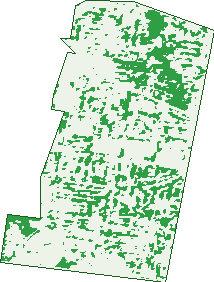
Green: 10 m cells where trees dominate, satellite 2021. Blue: water. The line is the suburb boundary.
| Canopy share, 1 m canopy height map, 2020 | 8.8% |
|---|---|
| Land with trees, 10 m satellite map, 2021 | 20.0% |
Demographics
Unemployment 4% · Labour-force participation 71%
Population by age in Murrumbeena
| 0-4 | 514 |
|---|---|
| 5-14 | 1,099 |
| 15-19 | 469 |
| 20-24 | 697 |
| 25-34 | 1,725 |
| 35-44 | 1,565 |
| 45-54 | 1,357 |
| 55-64 | 1,137 |
| 65-74 | 803 |
| 75-84 | 422 |
| 85+ | 201 |
Dwelling types in Murrumbeena
| House | 1,859 |
|---|---|
| Townhouse | 1,035 |
| Apartment | 1,176 |
| Other | 4 |
Households by weekly income in Murrumbeena
| <$650 | 523 |
|---|---|
| $650-1,499 | 927 |
| $1,500-2,999 | 1,167 |
| $3,000+ | 1,271 |
Top ancestries in Murrumbeena
| English | 2,602 |
|---|---|
| Australian | 2,368 |
| Other | 1,612 |
| Irish | 1,081 |
| Chinese | 993 |
| Scottish | 837 |
Housing tenure in Murrumbeena
| Owned | 1,205 |
|---|---|
| Mortgage | 1,311 |
| Rented | 1,487 |
| Other | 36 |
Cars per household in Murrumbeena
| 0 | 376 |
|---|---|
| 1 | 1,820 |
| 2 | 1,378 |
| 3 | 303 |
| 4+ | 151 |
Commute to work in Murrumbeena
| Car | 2,181 |
|---|---|
| Train | 259 |
| Bus | 47 |
| Tram/ferry | 5 |
| Walked | 103 |
| Bicycle | 48 |
| Home | 2,229 |
Top countries of birth in Murrumbeena
| India | 583 |
|---|---|
| China | 399 |
| Greece | 223 |
| England | 211 |
| New Zealand | 154 |
| Malaysia | 122 |
Languages used at home in Murrumbeena
| Mandarin | 540 |
|---|---|
| Greek | 537 |
| Russian | 140 |
| Cantonese | 127 |
| Gujarati | 124 |
| Hindi | 124 |
Birds & Wildlife Nearby
223,038 bird observations recorded near Murrumbeena — most often seen:
- Rainbow Lorikeet (17,230)
- Noisy Miner (16,322)
- Australian Magpie (16,282)
- Little Raven (15,818)
- Common Myna (14,326)
- Spotted Turtle-dove (14,270)
- Red Wattlebird (12,322)
- Magpie-lark (9,888)
- Eurasian Blackbird (9,276)
- Grey Butcherbird (7,372)
- Rock Dove (7,143)
- Pacific Black Duck (6,938)
- Common Starling (6,783)
Show all 30 birds recorded near Murrumbeena
- Brown Thornbill (6,117)
- Little Wattlebird (5,871)
- Welcome Swallow (5,505)
- White-plumed Honeyeater (4,990)
- Pied Currawong (4,944)
- Crested Pigeon (4,649)
- Dusky Moorhen (4,600)
- Chestnut Teal (3,775)
- Eurasian Coot (3,715)
- Australian Wood Duck (3,601)
- Silver Gull (3,368)
- House Sparrow (3,172)
- Galah (3,164)
- Australasian Purple Swamphen (3,151)
- Southern Victoria Australian Magpie (2,846)
- Little Pied Cormorant (2,834)
- White-browed Scrubwren (2,766)
Sightings reported by observers, not a survey, so the counts show what people record rather than what lives here. Source: Atlas of Living Australia.
Nearby Suburbs
The closest suburbs to Murrumbeena:
- Hughesdale (1.1 km)
- Carnegie (1.3 km)
- Malvern East (2.1 km)
- Oakleigh (2.2 km)
- Glen Huntly (2.5 km)
- Ormond (2.6 km)
- Caulfield East (2.6 km)
- Bentleigh East (2.9 km)
Embed this suburb
Add this free Murrumbeena stat card to your own site — just copy the code:
Preview:
Cite this page
Quoting these figures? Copy the credit line:
Keep an eye on Murrumbeena
One email when this data meaningfully changes — new census figures, prices, rankings. No spam, unsubscribe anytime.
Streets
- Adams Street (19)
- Adelaide Street (78)
- Anzac Street (1)
- Ardyne Street (147)
- Ariadne Avenue (16)
- Arthur Street (6)
- Astolat Avenue (6)
- Atkinson Street (38)
- Baker Street (23)
- Beauville Avenue (38)
- Belvoir Court (7)
- Blythe Street (15)
- Boake Street (14)
- Brett Street (61)
- Brisbane Street (74)
- Burns Avenue (19)
- Bute Street (84)
- Churchill Close (12)
- Clive Street (11)
- Crosbie Road (51)
- Daisy Street (12)
- Dalny Road (115)
- Dandenong Road (125)
- Donal Street (8)
- Doris Street (41)
- Dunoon Street (199)
- Ella Street (11)
- Erindale Street (36)
- First Avenue (34)
- George Street (14)
- Gerald Street (119)
- Gilsland Road (47)
- Gloucester Court (5)
- Gunn Street (8)
- Henty Street (29)
- Hethersett Grove (2)
- Hobart Road (139)
- Hooper Street (12)
- Howe Street (124)
- Innellan Road (50)
- Irving Avenue (21)
- Joyous Gard Court (6)
- Kangaroo Road (176)
- Katrina Avenue (24)
- Kinlock Avenue (82)
- Kirkham Road (20)
- Kitmont Street (38)
- Lawrance Street (39)
- Leila Road (7)
- Leura Street (33)
- Lindsay Avenue (46)
- Looker Street (21)
- Lydson Street (25)
- Margaretta Avenue (29)
- Marma Road (35)
- Maude Street (20)
- Melbourne Street (91)
- Merrimu Street (10)
- Montrose Court (4)
- Moonya Road (2)
- Murrumbeena Crescent (78)
- Murrumbeena Road (843)
- Nangana Road (14)
- Narbethong Road (16)
- Neerim Road (198)
- North Road (122)
- Oakleigh Road (1)
- Omama Road (63)
- Packer Street (35)
- Pelling Road (26)
- Perth Street (35)
- Poath Road (336)
- Railway Parade (157)
- Reid Street (72)
- Ricourt Avenue (29)
- Riley Street (10)
- Rosella Street (371)
- Second Avenue (26)
- Short Street (4)
- Spark Street (24)
- Stewart Street (20)
- Strathearn Avenue (49)
- Swan Road (28)
- Sydney Street (94)
- Thaxted Road (29)
- Thomson Avenue (27)
- Toward Street (131)
- Tuckett Street (4)
- Velra Avenue (22)
- Vera Street (13)
- Victory Street (51)
- Wahroongaa Crescent (44)
- Wahroongaa Road (34)
- Walker Street (27)
- Wallace Avenue (101)
- Weeroona Road (55)
- William Street (50)
- Wilson Street (39)
- Winston Way (34)
- Woornack Road (2)