Ormond VIC 3204
4,820 addresses · 67 streets
Goldstein Electorate › Glen Eira LGA › Ormond · 12 km from Melbourne
📦 Thinking of moving here? Read the Ormond moving guide

Living Here
Ormond is a suburb of Victoria, home to about 8,328 people, with a median age of 37. The typical household earns around $2,062 a week, with median rent near $395 a week. Most homes are houses. About 61% of households own their home and 38% rent. Most workers work from home. Common community backgrounds include English, Australian, Chinese. On the ABS socio-economic scale it sits in decile 10 of 10 nationally — a relatively advantaged area. The median house sells for about $1,855,500.
Over time — Census 2001 → 2021
Dashed line: district figures for the Ormond - Glen Huntly statistical area (SA2), the smallest area the ABS published before 2011. Solid line: Ormond itself.
Getting Around & Local Services
30 Catholic churches
- St. Finbar's East Brighton Parish
- St Peter's Catholic Church
- St Aloysius (Newman Parish)
- Saint Catherine Laboure Catholic Church
- Sacred Heart Oakleigh Catholic
- St Joseph's Catholic Church
- Immaculate Heart of Mary
- Our Lady of Perpetual Succour and Saint Andrew's Church
- St Joan of Arc Catholic Church
- St Agnes' Catholic Church
16 childcare & kindergartens
Getting around. Train station: Ormond, 250 m west · Tram stop: Stop 62: Grange Road, 1.6 km north · Bus interchange: Chadstone Shopping Centre, 4 km north-east · Airport: Moorabbin Airport, 9.7 km south-east.
Sport & Recreation
3 facilities recorded in Ormond.
- EE Gunn Reserve Australian Rules Football, Baseball, Cricket, Tennis (Outdoor)
- Glen Eira McKinnon Bowls Club Lawn Bowls
- St Kevin's Tennis Club Tennis (Outdoor)
Socio-economic Standing
Deciles from 1 (lowest) to 10 (highest), against all Australian suburbs. The overall figure weighs advantage and disadvantage together; economic resources counts income and housing, and education & jobs counts qualifications and occupation. They often differ. Source: ABS SEIFA 2021.
Median Sale Prices
Median of recorded sales in the period, not a valuation. Source: Victorian Property Sales Report, Land Use Victoria.
Tree cover
🌳 Tree canopy: 7.9% share of land under canopy · satellite map, 2020
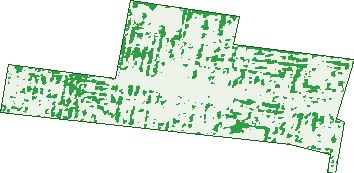
Green: 10 m cells where trees dominate, satellite 2021. Blue: water. The line is the suburb boundary.
| Canopy share, 1 m canopy height map, 2020 | 7.9% |
|---|---|
| Land with trees, 10 m satellite map, 2021 | 14.6% |
Demographics
Unemployment 4.9% · Labour-force participation 71%
Population by age in Ormond
| 0-4 | 376 |
|---|---|
| 5-14 | 1,032 |
| 15-19 | 565 |
| 20-24 | 592 |
| 25-34 | 1,319 |
| 35-44 | 1,156 |
| 45-54 | 1,270 |
| 55-64 | 954 |
| 65-74 | 621 |
| 75-84 | 334 |
| 85+ | 106 |
Dwelling types in Ormond
| House | 1,527 |
|---|---|
| Townhouse | 704 |
| Apartment | 1,038 |
| Other | 3 |
Households by weekly income in Ormond
| <$650 | 439 |
|---|---|
| $650-1,499 | 719 |
| $1,500-2,999 | 904 |
| $3,000+ | 1,055 |
Top ancestries in Ormond
| English | 2,041 |
|---|---|
| Australian | 1,895 |
| Other | 1,588 |
| Chinese | 902 |
| Irish | 787 |
| Scottish | 615 |
Housing tenure in Ormond
| Owned | 931 |
|---|---|
| Mortgage | 1,059 |
| Rented | 1,224 |
| Other | 31 |
Cars per household in Ormond
| 0 | 261 |
|---|---|
| 1 | 1,514 |
| 2 | 1,072 |
| 3 | 268 |
| 4+ | 106 |
Commute to work in Ormond
| Car | 1,792 |
|---|---|
| Train | 211 |
| Bus | 33 |
| Tram/ferry | 4 |
| Walked | 79 |
| Bicycle | 34 |
| Home | 1,828 |
Top countries of birth in Ormond
| India | 500 |
|---|---|
| China | 418 |
| England | 200 |
| South Africa | 162 |
| New Zealand | 109 |
| Greece | 105 |
Languages used at home in Ormond
| Mandarin | 560 |
|---|---|
| Greek | 295 |
| Russian | 278 |
| Hindi | 134 |
| Cantonese | 123 |
| Gujarati | 102 |
Birds & Wildlife Nearby
139,544 bird observations recorded near Ormond — most often seen:
- Rainbow Lorikeet (9,536)
- Noisy Miner (9,190)
- Little Raven (9,014)
- Australian Magpie (8,790)
- Common Myna (7,373)
- Magpie-lark (6,958)
- Rock Dove (6,768)
- Red Wattlebird (6,389)
- Spotted Turtle-dove (6,285)
- Pacific Black Duck (5,313)
- Common Starling (4,798)
- Welcome Swallow (4,716)
- Eurasian Blackbird (4,627)
Show all 30 birds recorded near Ormond
- Dusky Moorhen (4,270)
- Grey Butcherbird (4,257)
- Silver Gull (3,745)
- Crested Pigeon (3,342)
- Australian Wood Duck (3,308)
- Chestnut Teal (3,257)
- Australasian Purple Swamphen (3,161)
- Eurasian Coot (3,132)
- Pied Currawong (3,057)
- Brown Thornbill (2,654)
- House Sparrow (2,653)
- Little Pied Cormorant (2,376)
- Southern Victoria Australian Magpie (2,335)
- Little Wattlebird (2,305)
- White-faced Heron (2,106)
- Eastern Rosella (1,917)
- Eastern Rainbow Lorikeet (1,912)
Sightings reported by observers, not a survey, so the counts show what people record rather than what lives here. Source: Atlas of Living Australia.
Nearby Suburbs
The closest suburbs to Ormond:
- Mckinnon (0.9 km)
- Glen Huntly (1.3 km)
- Carnegie (1.8 km)
- Caulfield South (1.9 km)
- Bentleigh (2.1 km)
- Caulfield East (2.4 km)
- Brighton East (2.6 km)
- Murrumbeena (2.6 km)
Embed this suburb
Add this free Ormond stat card to your own site — just copy the code:
Preview:
Cite this page
Quoting these figures? Copy the credit line:
Keep an eye on Ormond
One email when this data meaningfully changes — new census figures, prices, rankings. No spam, unsubscribe anytime.
Streets
- Anthony Street (50)
- Arnott Street (49)
- Beatty Crescent (4)
- Bethell Street (65)
- Bevan Street (23)
- Bewdley Street (58)
- Blackshaw Street (14)
- Booran Road (72)
- Cadby Avenue (68)
- Carcoola Court (12)
- Carlyon Street (61)
- Centre Road (3)
- Coane Street (14)
- Collins Street (36)
- Dalmor Avenue (50)
- Draper Street (64)
- Dunlop Avenue (49)
- Etna Street (1)
- Florence Street (40)
- Foch Street (24)
- Fraser Street (30)
- Garfield Avenue (45)
- Glen Orme Avenue (83)
- Grange Road (281)
- Hall Street (29)
- Holloway Street (277)
- Howard Avenue (25)
- Jasper Road (80)
- Katandra Road (81)
- Koornang Road (27)
- Leila Road (130)
- Leinster Street (63)
- Lewis Street (27)
- Lillimur Road (378)
- Logan Avenue (8)
- Malane Street (76)
- Malua Street (26)
- Maud Street (23)
- Minette Court (4)
- Murray Road (77)
- Newham Grove (48)
- Nicholls Road (26)
- North Road (650)
- Oakleigh Crescent (30)
- Oakleigh Road (11)
- Ocean Street (24)
- Oloughlan Street (46)
- Olympia Court (6)
- Ormond Road (137)
- Parker Street (76)
- Queen Street (58)
- Ruby Street (18)
- Sherwood Street (10)
- Stewart Street (70)
- Thomas Street (2)
- Thompson Street (55)
- Tucker Road (62)
- Tyrone Street (31)
- Ulupna Road (345)
- Wallen Road (27)
- Walnut Street (44)
- Walsh Street (176)
- Wheatley Road (50)
- Wheeler Street (120)
- Wicklow Street (65)
- Wild Cherry Road (67)
- Wimmera Street (39)