Hughesdale VIC 3166
4,475 addresses · 57 streets
Hotham Electorate › Monash LGA › Hughesdale · 14 km from Melbourne
📦 Thinking of moving here? Read the Hughesdale moving guide

Living Here
Hughesdale is a suburb of Victoria, home to about 7,563 people, with a median age of 38. The typical household earns around $2,057 a week, with median rent near $416 a week. Most homes are houses. About 64% of households own their home and 35% rent. Most workers drive to work. Common community backgrounds include English, Australian, Greek. On the ABS socio-economic scale it sits in decile 10 of 10 nationally — a relatively advantaged area. The median house sells for about $1,421,000.
Over time — Census 2001 → 2021
Dashed line: district figures for the Hughesdale statistical area (SA2), the smallest area the ABS published before 2011. Solid line: Hughesdale itself.
Getting Around & Local Services
22 childcare & kindergartens
- Sts Anagiri Early Learning Centre
- Hughesdale Kindergarten
- Paisley Park Early Learning Centre
- Brine Street Child Care and Kindergarten
- Papilio Early Learning Murrumbeena
- Good Start Early Learning Centre
- Emmanuel Anglican Kindergarten
- Murrumbeena Children's Centre
- Ward Avenue Pre School
- Oakleigh Early Learning Journey
Getting around. Train station: Oakleigh, 600 m east · Tram stop: Stop 68: Koornang Road, 2.4 km west · Bus interchange: Chadstone Shopping Centre, 1.2 km north · Airport: Moorabbin Airport, 9.1 km south.
Sport & Recreation
2 facilities recorded in Hughesdale.
- Oakleigh Tennis Courts Tennis (Outdoor)
- Recreation Reserve Soccer
Socio-economic Standing
Deciles from 1 (lowest) to 10 (highest), against all Australian suburbs. The overall figure weighs advantage and disadvantage together; economic resources counts income and housing, and education & jobs counts qualifications and occupation. They often differ. Source: ABS SEIFA 2021.
Median Sale Prices
Median of recorded sales in the period, not a valuation. Source: Victorian Property Sales Report, Land Use Victoria.
Tree cover
🌳 Tree canopy: 7.6% share of land under canopy · satellite map, 2020
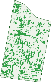
Green: 10 m cells where trees dominate, satellite 2021. Blue: water. The line is the suburb boundary.
| Canopy share, 1 m canopy height map, 2020 | 7.6% |
|---|---|
| Land with trees, 10 m satellite map, 2021 | 14.8% |
Demographics
Unemployment 4.2% · Labour-force participation 68.6%
Population by age in Hughesdale
| 0-4 | 353 |
|---|---|
| 5-14 | 828 |
| 15-19 | 385 |
| 20-24 | 581 |
| 25-34 | 1,261 |
| 35-44 | 1,091 |
| 45-54 | 1,098 |
| 55-64 | 856 |
| 65-74 | 532 |
| 75-84 | 371 |
| 85+ | 214 |
Dwelling types in Hughesdale
| House | 1,574 |
|---|---|
| Townhouse | 917 |
| Apartment | 444 |
| Other | 0 |
Households by weekly income in Hughesdale
| <$650 | 442 |
|---|---|
| $650-1,499 | 601 |
| $1,500-2,999 | 865 |
| $3,000+ | 905 |
Top ancestries in Hughesdale
| English | 1,690 |
|---|---|
| Australian | 1,617 |
| Other | 1,201 |
| Greek | 1,079 |
| Chinese | 808 |
| Irish | 679 |
Housing tenure in Hughesdale
| Owned | 918 |
|---|---|
| Mortgage | 930 |
| Rented | 1,019 |
| Other | 37 |
Cars per household in Hughesdale
| 0 | 284 |
|---|---|
| 1 | 1,270 |
| 2 | 1,017 |
| 3 | 241 |
| 4+ | 98 |
Commute to work in Hughesdale
| Car | 1,645 |
|---|---|
| Train | 196 |
| Bus | 50 |
| Tram/ferry | 0 |
| Walked | 99 |
| Bicycle | 26 |
| Home | 1,529 |
Top countries of birth in Hughesdale
| India | 440 |
|---|---|
| Greece | 401 |
| China | 387 |
| England | 142 |
| Sri Lanka | 104 |
| New Zealand | 97 |
Languages used at home in Hughesdale
| Greek | 892 |
|---|---|
| Mandarin | 468 |
| Hindi | 150 |
| Cantonese | 120 |
| Italian | 105 |
| Vietnamese | 88 |
Birds & Wildlife Nearby
331,837 bird observations recorded near Hughesdale — most often seen:
- Rainbow Lorikeet (22,972)
- Noisy Miner (22,902)
- Little Raven (22,290)
- Australian Magpie (21,966)
- Common Myna (19,925)
- Spotted Turtle-dove (18,820)
- Red Wattlebird (16,523)
- Magpie-lark (14,705)
- Eurasian Blackbird (13,741)
- Pacific Black Duck (11,496)
- Common Starling (10,874)
- Grey Butcherbird (9,948)
- Welcome Swallow (9,580)
Show all 30 birds recorded near Hughesdale
- Rock Dove (9,230)
- Dusky Moorhen (8,675)
- Brown Thornbill (8,534)
- Eurasian Coot (8,149)
- Little Wattlebird (7,837)
- White-plumed Honeyeater (7,479)
- Silver Gull (7,425)
- Australasian Purple Swamphen (7,264)
- Chestnut Teal (7,110)
- Crested Pigeon (7,057)
- Pied Currawong (6,191)
- House Sparrow (5,582)
- Little Pied Cormorant (5,543)
- Australian Wood Duck (5,355)
- Galah (5,131)
- Masked Lapwing (5,047)
- Grey Teal (4,486)
Sightings reported by observers, not a survey, so the counts show what people record rather than what lives here. Source: Atlas of Living Australia.
Nearby Suburbs
The closest suburbs to Hughesdale:
- Murrumbeena (1.1 km)
- Oakleigh (1.2 km)
- Carnegie (2.4 km)
- Huntingdale (2.5 km)
- Chadstone (2.5 km)
- Bentleigh East (2.9 km)
- Malvern East (2.9 km)
- Oakleigh East (3 km)
Embed this suburb
Add this free Hughesdale stat card to your own site — just copy the code:
Preview:
Cite this page
Quoting these figures? Copy the credit line:
Keep an eye on Hughesdale
One email when this data meaningfully changes — new census figures, prices, rankings. No spam, unsubscribe anytime.
Streets
- Ardgour Street (7)
- Argyle Close (21)
- Arthur Street (69)
- Austin Street (52)
- Barkly Street (29)
- Bletchley Road (79)
- Bowen Street (86)
- Bowmore Street (20)
- Brine Street (40)
- Bushbury Court (9)
- Calembeena Avenue (75)
- Callander Street (25)
- Camden Road (46)
- Canterbury Street (78)
- Carlisle Crescent (163)
- Clapham Road (75)
- Corr Street (8)
- Crewe Road (71)
- Dallas Avenue (102)
- Dalston Road (38)
- Dandenong Road (456)
- Darling Street (104)
- Dumblane Street (22)
- Earlstown Road (32)
- Eleebana Avenue (88)
- Ellendale Street (25)
- Euston Road (101)
- Federation Walk (28)
- Fellows Street (25)
- Fintonia Street (26)
- Freda Street (35)
- Halliday Court (6)
- Hotham Street (117)
- Kangaroo Road (242)
- Kelvinside Street (6)
- Kinrade Street (33)
- Latrobe Street (74)
- Long Place (12)
- Maroo Street (129)
- Moorookyle Avenue (73)
- Neerim Grove (15)
- Neerim Road (176)
- Normanby Street (88)
- North Road (74)
- Paddington Road (84)
- Paget Street (70)
- Poath Road (284)
- Preston Road (28)
- Rendell Court (10)
- Richardson Street (34)
- Rugby Road (70)
- Simmonds Street (77)
- Skipton Road (35)
- Swindon Road (184)
- Warrigal Road (269)
- Wilbur Crescent (16)
- Willesden Road (234)