Clayton VIC 3168
12,842 addresses · 147 streets
Hotham Electorate › Monash LGA › Clayton · 19 km from Melbourne
📦 Thinking of moving here? Read the Clayton moving guide

Living Here
A south-eastern Melbourne suburb home to a major university and medical precinct, Clayton is young and student-heavy. The median age is just 28 and households average 2.5 people. Median household income is $1,494 a week, with rent around $400.
Clayton is a suburb of Victoria, home to about 18,988 people, with a median age of 28. The typical household earns around $1,494 a week, with median rent near $400 a week. Most homes are townhouses. About 36% of households own their home and 62% rent. Most workers drive to work. Common community backgrounds include Chinese, Indian, English. On the ABS socio-economic scale it sits in decile 7 of 10 nationally — a mid-range area. The median house sells for about $1,165,000.
Over time — Census 2001 → 2021
Dashed line: district figures for the Clayton statistical area (SA2), the smallest area the ABS published before 2011. Solid line: Clayton itself.
Getting Around & Local Services
1 playground
Getting around. Train station: Clayton, 850 m south-west · Railway halt: Scoresby, 7.8 km east · Bus interchange: Monash University, 700 m north-east · Airport: Moorabbin Airport, 7.1 km south.
Sport & Recreation
10 facilities recorded in Clayton.
- Carlson Reserve Bocce, Cricket, Soccer, Tennis (Outdoor)
- Clayton Aquatics and Health Club Fitness / Gymnasium Workouts, Swimming
- Fernwood Clayton Fitness / Gymnasium Workouts
- Fregon Reserve Cricket, Rugby League
- Marshall Reserve Australian Rules Football, Baseball, Cricket, Soccer
- Meade Reserve Australian Rules Football, Cricket
- Melbourne Sports Stadium Cricket (Indoor), Soccer (Indoor Soccer / Futsal)
- Monash Uni Doug Ellis Swimming Pool Fitness / Gymnasium Workouts, Squash / Racquetball, Swimming
- Monash University - Clayton Hockey
- Monash University Baseball Club Baseball
Socio-economic Standing
Deciles from 1 (lowest) to 10 (highest), against all Australian suburbs. The overall figure weighs advantage and disadvantage together; economic resources counts income and housing, and education & jobs counts qualifications and occupation. They often differ. Source: ABS SEIFA 2021.
Median Sale Prices
Median of recorded sales in the period, not a valuation. Source: Victorian Property Sales Report, Land Use Victoria.
Tree cover
🌳 Tree canopy: 7.7% share of land under canopy · satellite map, 2020
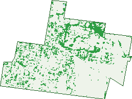
Green: 10 m cells where trees dominate, satellite 2021. Blue: water. The line is the suburb boundary.
| Canopy share, 1 m canopy height map, 2020 | 7.7% |
|---|---|
| Land with trees, 10 m satellite map, 2021 | 12.6% |
Demographics
Unemployment 9.7% · Labour-force participation 59.9%
Population by age in Clayton
| 0-4 | 697 |
|---|---|
| 5-14 | 871 |
| 15-19 | 1,192 |
| 20-24 | 4,186 |
| 25-34 | 5,811 |
| 35-44 | 2,088 |
| 45-54 | 1,201 |
| 55-64 | 1,025 |
| 65-74 | 784 |
| 75-84 | 656 |
| 85+ | 484 |
Dwelling types in Clayton
| House | 2,171 |
|---|---|
| Townhouse | 2,605 |
| Apartment | 1,331 |
| Other | 3 |
Households by weekly income in Clayton
| <$650 | 1,277 |
|---|---|
| $650-1,499 | 1,604 |
| $1,500-2,999 | 1,804 |
| $3,000+ | 1,055 |
Top ancestries in Clayton
| Chinese | 4,667 |
|---|---|
| Other | 4,249 |
| Indian | 2,556 |
| English | 2,065 |
| Australian | 1,823 |
| Ancestry NS | 1,661 |
Housing tenure in Clayton
| Owned | 1,142 |
|---|---|
| Mortgage | 1,039 |
| Rented | 3,719 |
| Other | 115 |
Cars per household in Clayton
| 0 | 1,019 |
|---|---|
| 1 | 2,765 |
| 2 | 1,625 |
| 3 | 396 |
| 4+ | 208 |
Commute to work in Clayton
| Car | 4,247 |
|---|---|
| Train | 428 |
| Bus | 312 |
| Tram/ferry | 6 |
| Walked | 533 |
| Bicycle | 79 |
| Home | 1,874 |
Top countries of birth in Clayton
| India | 3,122 |
|---|---|
| China | 2,796 |
| Sri Lanka | 679 |
| Malaysia | 642 |
| Greece | 517 |
| Vietnam | 423 |
Languages used at home in Clayton
| Mandarin | 3,313 |
|---|---|
| Greek | 868 |
| Hindi | 659 |
| Gujarati | 580 |
| Cantonese | 562 |
| Punjabi | 480 |
Birds & Wildlife Nearby
303,396 bird observations recorded near Clayton — most often seen:
- Little Raven (20,093)
- Noisy Miner (19,940)
- Rainbow Lorikeet (19,689)
- Australian Magpie (19,145)
- Common Myna (17,099)
- Spotted Turtle-dove (16,715)
- Red Wattlebird (14,611)
- Magpie-lark (13,312)
- Eurasian Blackbird (12,854)
- Pacific Black Duck (11,455)
- Common Starling (10,622)
- Welcome Swallow (9,002)
- Grey Butcherbird (8,638)
Show all 30 birds recorded near Clayton
- Eurasian Coot (8,634)
- Dusky Moorhen (8,610)
- Brown Thornbill (7,892)
- Australasian Purple Swamphen (7,752)
- White-plumed Honeyeater (7,546)
- Silver Gull (7,285)
- Little Wattlebird (7,018)
- Chestnut Teal (6,837)
- Crested Pigeon (6,734)
- Rock Dove (5,545)
- Australian Wood Duck (5,483)
- Little Pied Cormorant (5,456)
- House Sparrow (5,423)
- Masked Lapwing (5,182)
- Galah (4,986)
- Pied Currawong (4,936)
- Australasian Grebe (4,902)
Sightings reported by observers, not a survey, so the counts show what people record rather than what lives here. Source: Atlas of Living Australia.
Nearby Suburbs
The closest suburbs to Clayton:
- Oakleigh East (1.9 km)
- Clayton South (2.1 km)
- Huntingdale (2.1 km)
- Notting Hill (2.1 km)
- Clarinda (2.9 km)
- Oakleigh South (2.9 km)
- Oakleigh (3.5 km)
- Springvale (3.9 km)
Embed this suburb
Add this free Clayton stat card to your own site — just copy the code:
Preview:
Cite this page
Quoting these figures? Copy the credit line:
Keep an eye on Clayton
One email when this data meaningfully changes — new census figures, prices, rankings. No spam, unsubscribe anytime.
Streets
- Adaleigh Court (12)
- Alice Street (170)
- Alliance Lane (8)
- Ancora Imparo Way (31)
- Arnott Street (137)
- Atlantic Street (40)
- Auguste Avenue (39)
- Banksia Street (76)
- Bayview Avenue (19)
- Beddoe Avenue (139)
- Beleura Grove (12)
- Belmont Avenue (77)
- Bendix Drive (16)
- Bettina Street (139)
- Bimbi Street (6)
- Blackburn Road (634)
- Browns Court (21)
- Browns Road (455)
- Brushbox Court (35)
- Buckland Street (24)
- Burton Avenue (133)
- Cambro Road (88)
- Cantala Street (41)
- Carinish Road (207)
- Carlson Avenue (29)
- Caroline Street (8)
- Centre Road (219)
- Chancellors Walk (51)
- Clarkson Court (228)
- Clayton Road (549)
- Cobain Street (12)
- Colin Road (39)
- College Walk (28)
- College Way (7)
- Collier Avenue (5)
- Colonel Street (83)
- Connam Avenue (252)
- Cooke Street (17)
- Coombs Avenue (1)
- Dandenong Road (499)
- Dawson Court (9)
- Dennis Street (89)
- Dixon Street (97)
- Donald Street (53)
- Dooga Street (10)
- Duerdin Street (39)
- Dunstan Street (81)
- Edinburgh Street (120)
- Eva Street (168)
- Evelyn Street (177)
- Exhibition Walk (10)
- Faulkiner Street (49)
- Ferntree Gully Road (34)
- Flora Road (54)
- Florence Avenue (33)
- Fortuna Street (42)
- Francis Street (116)
- Fregon Road (13)
- Fulton Street (106)
- Garden Road (98)
- Gardiner Road (80)
- Gentle Street (15)
- Glenbrook Avenue (112)
- Greenfield Drive (74)
- Grovedale Court (10)
- Harlington Street (169)
- Harmony Court (8)
- Haughton Road (148)
- Henderson Road (51)
- Hilltop Avenue (33)
- Hourigan Avenue (92)
- Howard Court (32)
- Innovation Walk (13)
- Iona Street (30)
- Irwin Street (69)
- Jaguar Drive (168)
- Jazz Court (10)
- Jean Avenue (25)
- Kanooka Grove (239)
- Kay Court (14)
- Kionga Street (200)
- Koonawarra Street (191)
- Kumara Place (5)
- Lantana Street (42)
- Leaf Court (18)
- Lillian Street (70)
- Lindsay Street (13)
- Luke Street (27)
- Madeleine Road (206)
- Manatunga Street (49)
- Manton Road (102)
- Margaret Street (149)
- Marshall Avenue (172)
- Mary Street (51)
- Mcbean Street (27)
- Mcgregor Street (33)
- Mcnaughton Road (16)
- Monash Green Drive (62)
- Monash Place (14)
- Moriah Street (196)
- Morrison Street (19)
- Morton Street (109)
- Murdo Road (72)
- Murray Street (67)
- Music Drive (9)
- Myriong Street (92)
- Nantilla Road (24)
- Nicholson Court (66)
- Normanby Road (1)
- North Road (291)
- Opera Court (10)
- Ormond Road (210)
- Panorama Street (167)
- Parker Street (13)
- Penn Street (20)
- Prince Charles Street (171)
- Prince Street (42)
- Pullyn Street (14)
- Rainforest Walk (19)
- Renver Road (272)
- Research Way (7)
- Robinson Street (80)
- Rockbeare Court (5)
- Rose Street (59)
- Royalty Street (45)
- Sarton Road (103)
- Scenic Boulevard (15)
- Scotsburn Avenue (81)
- Seascape Street (80)
- Shady Mews (12)
- Shandeau Avenue (7)
- Sports Walk (8)
- Stockdale Avenue (327)
- Swing Court (11)
- Tarella Road (1)
- Thomas Street (63)
- Thompson Street (113)
- Torteval Place (8)
- Treforest Drive (37)
- University Place (10)
- View Street (156)
- Wellington Road (644)
- Whitburn Street (19)
- Winterton Road (100)
- Woodside Avenue (8)
- Wright Street (99)
- Yarram Crescent (37)