Salisbury QLD 4107
3,577 addresses · 98 streets
Moreton Electorate › Brisbane LGA › Salisbury · 9 km from Brisbane
📦 Thinking of moving here? Read the Salisbury moving guide

Living Here
Salisbury is a suburb of Queensland, home to about 6,790 people, with a median age of 35. The typical household earns around $2,133 a week, with median rent near $400 a week. Most homes are houses. About 69% of households own their home and 30% rent. Most workers drive to work. Common community backgrounds include English, Australian, Irish. On the ABS socio-economic scale it sits in decile 9 of 10 nationally — a relatively advantaged area.
Over time — Census 2001 → 2021
Dashed line: district figures for the Salisbury - Nathan statistical area (SA2), the smallest area the ABS published before 2011. Solid line: Salisbury itself.
Getting Around & Local Services
3 pharmacies
5 doctors & medical clinics
10 childcare & kindergartens
- C&K Salisbury Community Kindergarten
- Tzu Chi Early Learning Centre
- Life Early Learning Centre
- Goodstart Early Learning Coopers Plains
- Goodstart Early Learning Robertson
- St. Brendan's Child Care Centre
- Prior Street Child Care & Development
- Tarragindi Child Care & Development
- Guardian Childcare & Education Coopers Plains
- Edge Early Learning
4 beauty salons
Getting around. Train station: Salisbury, 1.1 km west · Bus interchange: Griffith University, 3 km east · Ferry wharf: UQ St Lucia ferry terminal, 6.3 km north · Airport: Brisbane Airport, 21 km north-east.
Socio-economic Standing
Deciles from 1 (lowest) to 10 (highest), against all Australian suburbs. The overall figure weighs advantage and disadvantage together; economic resources counts income and housing, and education & jobs counts qualifications and occupation. They often differ. Source: ABS SEIFA 2021.
Tree cover
🌳 Tree canopy: 21.9% share of land under canopy · satellite map, 2020
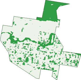
Green: 10 m cells where trees dominate, satellite 2021. Blue: water. The line is the suburb boundary.
| Canopy share, 1 m canopy height map, 2020 | 21.9% |
|---|---|
| Land with trees, 10 m satellite map, 2021 | 23.7% |
Demographics
Unemployment 4.9% · Labour-force participation 71.1%
Population by age in Salisbury
| 0-4 | 476 |
|---|---|
| 5-14 | 891 |
| 15-19 | 348 |
| 20-24 | 433 |
| 25-34 | 1,178 |
| 35-44 | 1,150 |
| 45-54 | 845 |
| 55-64 | 649 |
| 65-74 | 372 |
| 75-84 | 268 |
| 85+ | 181 |
Dwelling types in Salisbury
| House | 2,161 |
|---|---|
| Townhouse | 200 |
| Apartment | 56 |
| Other | 4 |
Households by weekly income in Salisbury
| <$650 | 300 |
|---|---|
| $650-1,499 | 528 |
| $1,500-2,999 | 777 |
| $3,000+ | 702 |
Top ancestries in Salisbury
| English | 2,350 |
|---|---|
| Australian | 2,212 |
| Other | 961 |
| Irish | 840 |
| Scottish | 745 |
| Chinese | 354 |
Housing tenure in Salisbury
| Owned | 579 |
|---|---|
| Mortgage | 1,080 |
| Rented | 729 |
| Other | 26 |
Cars per household in Salisbury
| 0 | 128 |
|---|---|
| 1 | 876 |
| 2 | 1,001 |
| 3 | 286 |
| 4+ | 130 |
Commute to work in Salisbury
| Car | 2,048 |
|---|---|
| Train | 115 |
| Bus | 124 |
| Tram/ferry | 0 |
| Walked | 54 |
| Bicycle | 40 |
| Home | 694 |
Top countries of birth in Salisbury
| India | 277 |
|---|---|
| New Zealand | 202 |
| England | 174 |
| Vietnam | 63 |
| China | 60 |
| Philippines | 56 |
Languages used at home in Salisbury
| Mandarin | 125 |
|---|---|
| Gujarati | 99 |
| Cantonese | 82 |
| Spanish | 82 |
| Vietnamese | 81 |
| Hindi | 54 |
Birds & Wildlife Nearby
278,218 bird observations recorded near Salisbury — most often seen:
- Noisy Miner (18,488)
- Torresian Crow (17,765)
- Rainbow Lorikeet (15,971)
- Grey Butcherbird (12,961)
- Pied Currawong (11,924)
- Australian Magpie (11,154)
- Laughing Kookaburra (10,247)
- Australian White Ibis (9,986)
- Welcome Swallow (9,778)
- Willie Wagtail (9,707)
- Australian Brush-turkey (9,602)
- Brown Honeyeater (8,942)
- Magpie-lark (8,927)
Show all 30 birds recorded near Salisbury
- Lewin's Honeyeater (8,313)
- Red-backed Fairy-wren (8,244)
- Pacific Black Duck (8,154)
- Pied Butcherbird (8,012)
- Masked Lapwing (7,524)
- Australasian Purple Swamphen (7,469)
- Australasian Figbird (7,435)
- Superb Fairy-wren (7,396)
- Black-faced Cuckoo-shrike (7,382)
- Dusky Moorhen (7,109)
- Striated Pardalote (7,007)
- Scaly-breasted Lorikeet (6,849)
- Silvereye (6,601)
- Blue-faced Honeyeater (6,533)
- Grey Shrike-thrush (6,410)
- Crested Pigeon (6,313)
- Bar-shouldered Dove (6,015)
Sightings reported by observers, not a survey, so the counts show what people record rather than what lives here. Source: Atlas of Living Australia.
Nearby Suburbs
The closest suburbs to Salisbury:
- Nathan (1.4 km)
- Coopers Plains (1.7 km)
- Archerfield (2.2 km)
- Rocklea (2.3 km)
- Moorooka (2.3 km)
- Robertson (2.6 km)
- Tarragindi (3.1 km)
- Yeerongpilly (3.5 km)
Embed this suburb
Add this free Salisbury stat card to your own site — just copy the code:
Preview:
Cite this page
Quoting these figures? Copy the credit line:
Keep an eye on Salisbury
One email when this data meaningfully changes — new census figures, prices, rankings. No spam, unsubscribe anytime.
Streets
- Ainger Street (13)
- Ainsworth Street (74)
- Aird Street (25)
- Allandale Street (39)
- Althea Street (56)
- Angela Street (21)
- Assembly Street (25)
- Basil Street (10)
- Beaudesert Road (10)
- Bellevue Avenue (27)
- Bidder Street (42)
- Birchdale Street (23)
- Blackwood Road (106)
- Blomfield Street (2)
- Burgess Street (13)
- Bye Street (1)
- Caedmon Street (18)
- Canfield Street (7)
- Chalfont Street (63)
- Chrome Street (37)
- Commerce Street (7)
- Courtland Street (46)
- Cripps Street (31)
- Debra Street (23)
- Dollis Street (2)
- Douglas Road (105)
- Dulcie Street (10)
- Edna Street (10)
- Elma Street (45)
- Engineering Street (2)
- Enterprise Street (11)
- Evans Road (189)
- Fairlawn Street (10)
- Fairlie Terrace (5)
- Flanders Street (52)
- Frewin Street (5)
- Georgina Street (43)
- Golda Avenue (80)
- Greer Road (38)
- Harlen Road (136)
- Hatton Street (12)
- Hayling Street (30)
- Henson Road (181)
- Holborn Street (3)
- Humber Street (43)
- Industries Road (9)
- Jaybel Street (23)
- Kellett Road (31)
- Kessels Road (40)
- Kneller Street (12)
- Lathe Street (4)
- Launceston Street (42)
- Leah Avenue (51)
- Lillian Avenue (272)
- Lily Street (11)
- Lowndes Street (35)
- Maitland Street (28)
- Maltby Street (4)
- Malvern Street (23)
- Marfayley Street (18)
- Massinger Street (60)
- Maurice Avenue (33)
- Maverton Street (15)
- Mayfield Road (1)
- Mccarthy Road (46)
- Meldrum Street (11)
- Melina Street (35)
- Meynell Street (38)
- Myra Road (22)
- Ness Road (100)
- Nicholson Avenue (27)
- Norval Street (19)
- Olivia Avenue (28)
- Orange Grove Road (175)
- Penrith Street (20)
- Pentex Street (23)
- Perrin Place (14)
- Pevny Street (34)
- Portsdown Street (18)
- Precision Street (16)
- Project Street (2)
- Raynham Street (15)
- Regis Street (22)
- Riawena Road (10)
- Rosebank Square (33)
- Salford Street (41)
- Sheridan Street (12)
- Southey Street (19)
- Standish Street (17)
- Tamblyn Road (23)
- Tarragindi Road (34)
- Textile Crescent (8)
- Toms Street (4)
- Toohey Road (85)
- Toorak Road (19)
- Tuckett Road (75)
- Wincott Street (16)
- Winsome Road (73)