Moorooka QLD 4105
6,598 addresses · 146 streets
Moreton Electorate › Brisbane LGA › Moorooka · 7 km from Brisbane
📦 Thinking of moving here? Read the Moorooka moving guide

Living Here
Moorooka is a suburb of Queensland, home to about 10,783 people, with a median age of 36. The typical household earns around $1,864 a week, with median rent near $360 a week. Most homes are houses. About 58% of households own their home and 41% rent. Most workers drive to work. Common community backgrounds include English, Australian, Irish. On the ABS socio-economic scale it sits in decile 9 of 10 nationally — a relatively advantaged area.
Over time — Census 2001 → 2021
Dashed line: district figures for the Moorooka statistical area (SA2), the smallest area the ABS published before 2011. Solid line: Moorooka itself.
Getting Around & Local Services
1 playground
Getting around. Train station: Yeerongpilly, 1.4 km north-west · Bus interchange: Greenslopes, 3.1 km north-east · Ferry wharf: UQ St Lucia ferry terminal, 4.2 km north · Airport: Brisbane Airport, 19.8 km north-east.
Socio-economic Standing
Deciles from 1 (lowest) to 10 (highest), against all Australian suburbs. The overall figure weighs advantage and disadvantage together; economic resources counts income and housing, and education & jobs counts qualifications and occupation. They often differ. Source: ABS SEIFA 2021.
Tree cover
🌳 Tree canopy: 19.9% share of land under canopy · satellite map, 2020
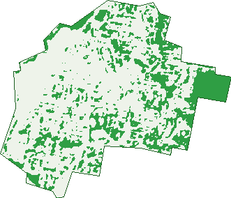
Green: 10 m cells where trees dominate, satellite 2021. Blue: water. The line is the suburb boundary.
| Canopy share, 1 m canopy height map, 2020 | 19.9% |
|---|---|
| Land with trees, 10 m satellite map, 2021 | 22.4% |
Demographics
Unemployment 4.8% · Labour-force participation 70.5%
Population by age in Moorooka
| 0-4 | 633 |
|---|---|
| 5-14 | 1,233 |
| 15-19 | 470 |
| 20-24 | 824 |
| 25-34 | 2,011 |
| 35-44 | 1,747 |
| 45-54 | 1,497 |
| 55-64 | 1,104 |
| 65-74 | 709 |
| 75-84 | 379 |
| 85+ | 171 |
Dwelling types in Moorooka
| House | 2,691 |
|---|---|
| Townhouse | 690 |
| Apartment | 1,057 |
| Other | 0 |
Households by weekly income in Moorooka
| <$650 | 705 |
|---|---|
| $650-1,499 | 1,014 |
| $1,500-2,999 | 1,384 |
| $3,000+ | 1,119 |
Top ancestries in Moorooka
| English | 3,954 |
|---|---|
| Australian | 3,425 |
| Other | 1,765 |
| Irish | 1,618 |
| Scottish | 1,358 |
| German | 668 |
Housing tenure in Moorooka
| Owned | 983 |
|---|---|
| Mortgage | 1,570 |
| Rented | 1,820 |
| Other | 38 |
Cars per household in Moorooka
| 0 | 388 |
|---|---|
| 1 | 1,905 |
| 2 | 1,566 |
| 3 | 379 |
| 4+ | 166 |
Commute to work in Moorooka
| Car | 3,235 |
|---|---|
| Train | 153 |
| Bus | 268 |
| Tram/ferry | 0 |
| Walked | 85 |
| Bicycle | 101 |
| Home | 1,221 |
Top countries of birth in Moorooka
| England | 311 |
|---|---|
| New Zealand | 310 |
| India | 190 |
| Vietnam | 115 |
| Philippines | 92 |
| China | 63 |
Languages used at home in Moorooka
| Spanish | 146 |
|---|---|
| Vietnamese | 142 |
| Arabic | 81 |
| Mandarin | 78 |
| Greek | 76 |
| Punjabi | 75 |
Birds & Wildlife Nearby
446,202 bird observations recorded near Moorooka — most often seen:
- Noisy Miner (31,498)
- Torresian Crow (29,030)
- Rainbow Lorikeet (26,478)
- Grey Butcherbird (20,707)
- Australian Magpie (19,212)
- Pied Currawong (18,857)
- Welcome Swallow (18,623)
- Australian White Ibis (18,340)
- Magpie-lark (15,751)
- Australian Brush-turkey (15,322)
- Pied Butcherbird (15,179)
- Laughing Kookaburra (14,979)
- Scaly-breasted Lorikeet (14,299)
Show all 30 birds recorded near Moorooka
- Australasian Figbird (14,190)
- Willie Wagtail (14,034)
- Pacific Black Duck (13,020)
- Masked Lapwing (12,643)
- Dusky Moorhen (12,365)
- Brown Honeyeater (11,861)
- Australasian Purple Swamphen (11,756)
- Blue-faced Honeyeater (10,914)
- Crested Pigeon (10,700)
- Sulphur-crested Cockatoo (10,022)
- Spotted Turtle-dove (9,838)
- Australian Wood Duck (9,793)
- Striated Pardalote (9,711)
- Little Black Cormorant (9,467)
- Black-faced Cuckoo-shrike (9,444)
- Australasian Darter (9,239)
- Red-backed Fairy-wren (8,930)
Sightings reported by observers, not a survey, so the counts show what people record rather than what lives here. Source: Atlas of Living Australia.
Nearby Suburbs
The closest suburbs to Moorooka:
- Yeerongpilly (1.2 km)
- Tennyson (2.1 km)
- Salisbury (2.3 km)
- Rocklea (2.3 km)
- Tarragindi (2.3 km)
- Yeronga (2.3 km)
- Nathan (2.4 km)
- Annerley (2.6 km)
Embed this suburb
Add this free Moorooka stat card to your own site — just copy the code:
Preview:
Cite this page
Quoting these figures? Copy the credit line:
Keep an eye on Moorooka
One email when this data meaningfully changes — new census figures, prices, rankings. No spam, unsubscribe anytime.
Streets
- Abel Street (22)
- Abney Street (19)
- Amery Street (46)
- Anson Street (38)
- Anzac Lane (1)
- Avison Street (31)
- Baldock Street (46)
- Barford Street (33)
- Beaudesert Road (478)
- Beckford Street (43)
- Belair Street (14)
- Bellhurst Outlook (2)
- Beulah Street (7)
- Beverley Hill Street (86)
- Blackburn Lane (29)
- Blackburn Street (65)
- Blomfield Street (42)
- Bohain Street (1)
- Bracken Street (49)
- Brier Street (32)
- Carson Street (28)
- Caskey Street (1)
- Charmaine Street (40)
- Chaucer Street (280)
- Citrus Street (31)
- Clifton Street (41)
- Clyde Street (20)
- Cobden Street (34)
- Coin Street (2)
- Colebrook Avenue (4)
- Cornford Street (10)
- Corsica Street (21)
- Currey Avenue (46)
- Cutler Avenue (8)
- Davey Road (1)
- Davey Street (17)
- Delville Avenue (66)
- Derrick Street (20)
- Desanne Place (14)
- Dexter Street (21)
- Dinmore Street (63)
- Dora Street (59)
- Dunstan Street (29)
- Durack Street (199)
- Ellen Street (28)
- Eric Crescent (1)
- Errington Street (31)
- Evans Road (2)
- Evesham Street (16)
- Fairy Street (84)
- Fegen Drive (134)
- Feldt Street (8)
- Fincastle Street (12)
- Fleurs Street (1)
- Forest Street (117)
- Gaba Tepe Street (34)
- Gainsborough Street (280)
- Giardini Lane (1)
- Gladstone Street (39)
- Glen Street (54)
- Glendale Grove (23)
- Goodwin Terrace (140)
- Gow Street (12)
- Gratwick Street (5)
- Hamilton Road (275)
- Hansen Street (190)
- Hare Street (4)
- Harlock Street (18)
- Hawtree Street (44)
- Heilly Street (5)
- Helles Street (99)
- Hermes Street (15)
- Herring Street (26)
- Hillview Terrace (20)
- Holmes Street (59)
- Homestead Street (54)
- Horatio Street (1)
- Hyslop Street (9)
- Industries Road (2)
- Ipswich Road (162)
- John Bright Street (33)
- Keats Street (180)
- Kensal Street (19)
- Kenway Street (9)
- Kerrianne Place (12)
- Kibby Street (3)
- Kiltie Street (16)
- Kine Street (15)
- Kingwell Street (12)
- Kipling Street (60)
- Koala Road (133)
- La Monte Street (25)
- Longueval Street (33)
- Lucy Street (22)
- Luxworth Street (30)
- Lyon Street (207)
- Mackie Street (19)
- Mackie Street E (19)
- Mackie Street W (16)
- Madang Street (4)
- Mametz Street (17)
- Mathilda Street (9)
- Mayfield Road (141)
- Medina Street (25)
- Michlin Street (28)
- Millicent Street (37)
- Moorland Street (14)
- Moresby Street (9)
- Moriac Street (11)
- Morshead Street (72)
- Muriel Avenue (118)
- Nettleton Crescent (39)
- Newman Road (25)
- Northview Outlook (47)
- O'neil Street (40)
- Pampas Street (4)
- Patricia Street (18)
- Piers Street (49)
- Purcell Street (11)
- Rabaul Street (33)
- Rachael Street (36)
- Robinson Street (46)
- Rosling Street (20)
- Scherger Street (38)
- Sharon Street (11)
- Sherley Street (31)
- Sinclair Street (13)
- Southwell Street (17)
- Tarragindi Road (124)
- Tennessee Avenue (1)
- Timbury Street (20)
- Timothy Street (33)
- Tonks Street (39)
- Truscott Street (29)
- Unwin Street (27)
- Vale Street (48)
- Vasey Street (19)
- Vendale Avenue (62)
- Wallace Street (85)
- Waterlot Street (29)
- Weir Street (28)
- Wharton Street (29)
- Whittle Street (10)
- Woodlea Street (31)
- Woodridge Street (8)
- Zonnebeke Street (6)