Tarragindi QLD 4121
5,022 addresses · 136 streets
Moreton Electorate › Brisbane LGA › Tarragindi · 6 km from Brisbane
📦 Thinking of moving here? Read the Tarragindi moving guide

Living Here
Tarragindi is a suburb of Queensland, home to about 11,035 people, with a median age of 37. The typical household earns around $2,934 a week, with median rent near $450 a week. Most homes are houses. About 79% of households own their home and 20% rent. Most workers drive to work. Common community backgrounds include English, Australian, Irish. On the ABS socio-economic scale it sits in decile 10 of 10 nationally — a relatively advantaged area.
Over time — Census 2001 → 2021
Dashed line: district figures for the Tarragindi statistical area (SA2), the smallest area the ABS published before 2011. Solid line: Tarragindi itself.
Getting Around & Local Services
51 schools
24 childcare & kindergartens
- The Learning Sanctuary Tarragindi
- Edge Early Learning
- Tarragindi War Memorial Kindergarden
- Tarragindi Child Care & Development
- Prior Street Child Care & Development
- Goodstart Early Learning Tarragindi
- Arnwood Place Community Childcare Centre
- C&K Mott Park Kindergarten
- Edge Early Learning
- Little Ducks Childcare
1 playground
Getting around. Train station: Fairfield, 2.5 km north-west · Bus interchange: Holland Park West station, 1.3 km east · Ferry wharf: UQ St Lucia ferry terminal, 4.1 km north-west · Airport: Brisbane Airport, 18 km north-east.
Socio-economic Standing
Deciles from 1 (lowest) to 10 (highest), against all Australian suburbs. The overall figure weighs advantage and disadvantage together; economic resources counts income and housing, and education & jobs counts qualifications and occupation. They often differ. Source: ABS SEIFA 2021.
Tree cover
🌳 Tree canopy: 28.7% share of land under canopy · satellite map, 2020
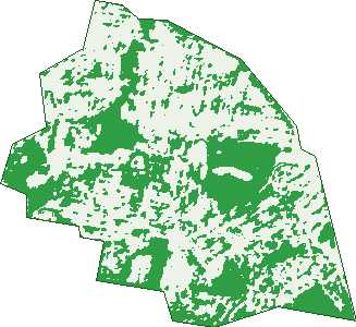
Green: 10 m cells where trees dominate, satellite 2021. Blue: water. The line is the suburb boundary.
| Canopy share, 1 m canopy height map, 2020 | 28.7% |
|---|---|
| Land with trees, 10 m satellite map, 2021 | 39.7% |
Demographics
Unemployment 3.3% · Labour-force participation 73.5%
Population by age in Tarragindi
| 0-4 | 738 |
|---|---|
| 5-14 | 1,782 |
| 15-19 | 737 |
| 20-24 | 615 |
| 25-34 | 1,182 |
| 35-44 | 1,826 |
| 45-54 | 1,672 |
| 55-64 | 1,164 |
| 65-74 | 697 |
| 75-84 | 417 |
| 85+ | 199 |
Dwelling types in Tarragindi
| House | 3,553 |
|---|---|
| Townhouse | 107 |
| Apartment | 76 |
| Other | 0 |
Households by weekly income in Tarragindi
| <$650 | 298 |
|---|---|
| $650-1,499 | 632 |
| $1,500-2,999 | 874 |
| $3,000+ | 1,747 |
Top ancestries in Tarragindi
| English | 4,262 |
|---|---|
| Australian | 4,087 |
| Irish | 1,836 |
| Scottish | 1,368 |
| Other | 1,270 |
| German | 674 |
Housing tenure in Tarragindi
| Owned | 1,224 |
|---|---|
| Mortgage | 1,706 |
| Rented | 760 |
| Other | 31 |
Cars per household in Tarragindi
| 0 | 136 |
|---|---|
| 1 | 1,187 |
| 2 | 1,669 |
| 3 | 492 |
| 4+ | 236 |
Commute to work in Tarragindi
| Car | 3,061 |
|---|---|
| Train | 16 |
| Bus | 338 |
| Tram/ferry | 3 |
| Walked | 60 |
| Bicycle | 137 |
| Home | 1,481 |
Top countries of birth in Tarragindi
| England | 328 |
|---|---|
| New Zealand | 237 |
| Japan | 130 |
| India | 91 |
| China | 87 |
| Vietnam | 73 |
Languages used at home in Tarragindi
| Japanese | 242 |
|---|---|
| Mandarin | 147 |
| Greek | 133 |
| Vietnamese | 95 |
| Spanish | 89 |
| Cantonese | 62 |
Birds & Wildlife Nearby
243,295 bird observations recorded near Tarragindi — most often seen:
- Noisy Miner (21,822)
- Torresian Crow (19,697)
- Rainbow Lorikeet (18,731)
- Pied Currawong (13,810)
- Grey Butcherbird (12,955)
- Australian Magpie (10,422)
- Welcome Swallow (10,129)
- Laughing Kookaburra (9,736)
- Scaly-breasted Lorikeet (9,613)
- Australian Brush-turkey (9,261)
- Australian White Ibis (9,156)
- Pied Butcherbird (8,741)
- Magpie-lark (7,612)
Show all 30 birds recorded near Tarragindi
- Australasian Figbird (6,917)
- Dusky Moorhen (6,002)
- Striated Pardalote (5,795)
- Willie Wagtail (5,446)
- Pacific Black Duck (5,445)
- Australian Wood Duck (5,424)
- Masked Lapwing (5,039)
- Tawny Frogmouth (4,829)
- Little Corella (4,387)
- Crested Pigeon (4,384)
- Sulphur-crested Cockatoo (4,299)
- Black-faced Cuckoo-shrike (4,180)
- Spotted Turtle-dove (4,157)
- Blue-faced Honeyeater (3,908)
- Australasian Darter (3,901)
- Noisy Friarbird (3,780)
- Brown Honeyeater (3,717)
Sightings reported by observers, not a survey, so the counts show what people record rather than what lives here. Source: Atlas of Living Australia.
Nearby Suburbs
The closest suburbs to Tarragindi:
- Holland Park West (1.6 km)
- Nathan (2 km)
- Annerley (2 km)
- Greenslopes (2 km)
- Moorooka (2.3 km)
- Holland Park (2.6 km)
- Yeerongpilly (2.8 km)
- Fairfield (2.9 km)
Embed this suburb
Add this free Tarragindi stat card to your own site — just copy the code:
Preview:
Cite this page
Quoting these figures? Copy the credit line:
Keep an eye on Tarragindi
One email when this data meaningfully changes — new census figures, prices, rankings. No spam, unsubscribe anytime.
Streets
- Alcorn Street (9)
- Aldora Street (11)
- Amulree Street (18)
- Andrea Street (24)
- Andrew Avenue (228)
- Arkwright Street (33)
- Arunta Street (28)
- Askew Street (19)
- Bailey Avenue (17)
- Bapaume Road (3)
- Barkley Street (10)
- Barmore Street (79)
- Barnehurst Street (61)
- Barr Street (11)
- Bellhurst Outlook (17)
- Belvedere Street (15)
- Benbow Street (33)
- Bilsand Street (14)
- Birdwood Road (14)
- Bourrelet Street (21)
- Bovill Street (4)
- Bramston Street (85)
- Brendon Street (14)
- Brett Street (7)
- Cambrae Street (1)
- Cavan Street (3)
- Chadwick Street (13)
- Chamberlain Street (43)
- Chester Road (5)
- Cheval Street (5)
- Connah Street (27)
- Coromandel Street (13)
- Cracknell Road (93)
- Craigmont Street (41)
- Cramer Street (18)
- Cranham Street (12)
- Cropthorne Street (20)
- Dahl Street (25)
- Davina Street (4)
- Dellwood Street (1)
- Denham Terrace (54)
- Downes Street (53)
- Eckersley Street (8)
- Effingham Street (86)
- Ekibin Road (27)
- Ekibin Road E (189)
- Ellington Street (108)
- Elliot Street (6)
- Esher Street (26)
- Essie Avenue (13)
- Essie Street (2)
- Esther Street (42)
- Fernvale Road (67)
- Ferrand Street (18)
- Filewood Street (1)
- Fingal Street (137)
- Gapap Street (12)
- Garioch Street (20)
- Gerard Street (13)
- Gilmore Street (33)
- Glenaplin Avenue (14)
- Glencoe Avenue (21)
- Greenhalgh Street (10)
- Heathwhite Street (20)
- Hexham Street (40)
- Hine Street (6)
- Isabella Street (50)
- Joywood Street (18)
- Kara Street (7)
- Kaypee Street (8)
- Kenneth Street (20)
- Kivas Street (30)
- Kogarah Street (36)
- Kuring Gai Avenue (46)
- Kuring-gai Avenue (50)
- Lana Street (32)
- Landor Street (38)
- Langham Street (15)
- Laura Street (114)
- Lawrie Street (13)
- Lisle Street (28)
- Lutzow Street (126)
- Marchant Street (15)
- Marieander Street (40)
- Marlton Street (12)
- Marshall Road (61)
- Mayfield Road (8)
- Mayheck Street (11)
- Mcguire Street (4)
- Messines Ridge Road (30)
- Monash Road (149)
- Monkton Street (35)
- Moorbell Street (53)
- Newington Street (44)
- Northview Outlook (2)
- Nurinda Lane (4)
- Orford Street (50)
- Pallaranda Street (38)
- Passchendaele Street (29)
- Pauline Street (30)
- Pemberton Street (17)
- Pentire Street (1)
- Percy Street (43)
- Peronne Road (11)
- Playfair Street (12)
- Pope Street (70)
- Pozieres Road (76)
- Pring Street (107)
- Prior Street (110)
- Queensthorpe Street (24)
- Rapkin Street (28)
- Rochdale Avenue (52)
- Ruby Avenue (11)
- Salkeld Street (30)
- Sexton Street (75)
- Shaftesbury Street (121)
- Shepstone Street (5)
- Skyline Avenue (6)
- Snowden Street (14)
- Solna Street (9)
- Strathfield Street (22)
- Sunshine Avenue (49)
- Tamarang Street (20)
- Tarragindi Road (106)
- Tennessee Avenue (14)
- Thornycroft Street (33)
- Toohey Road (190)
- Turramurra Road (21)
- Vinray Street (24)
- Vista Avenue (49)
- Weal Avenue (52)
- Weller Road (139)
- Willis Street (42)
- Windmill Street (62)
- Wonderlost Outlook (2)
- Woolton Street (4)