Annerley QLD 4103
7,590 addresses · 118 streets
Moreton Electorate › Brisbane LGA › Annerley · 5 km from Brisbane
📦 Thinking of moving here? Read the Annerley moving guide

Living Here
Annerley is a suburb of Queensland, home to about 11,891 people, with a median age of 33. The typical household earns around $1,830 a week, with median rent near $360 a week. Most homes are houses. About 44% of households own their home and 55% rent. Most workers drive to work. Common community backgrounds include English, Australian, Irish. On the ABS socio-economic scale it sits in decile 9 of 10 nationally — a relatively advantaged area.
Over time — Census 2001 → 2021
Dashed line: district figures for the Annerley statistical area (SA2), the smallest area the ABS published before 2011. Solid line: Annerley itself.
Getting Around & Local Services
26 childcare & kindergartens
Getting around. Train station: Fairfield, 500 m north-west · Bus interchange: Greenslopes, 800 m east · Ferry wharf: UQ St Lucia ferry terminal, 2.1 km north-west · Airport: Brisbane Airport, 17.2 km north-east.
Socio-economic Standing
Deciles from 1 (lowest) to 10 (highest), against all Australian suburbs. The overall figure weighs advantage and disadvantage together; economic resources counts income and housing, and education & jobs counts qualifications and occupation. They often differ. Source: ABS SEIFA 2021.
Tree cover
🌳 Tree canopy: 18.1% share of land under canopy · satellite map, 2020
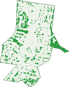
Green: 10 m cells where trees dominate, satellite 2021. Blue: water. The line is the suburb boundary.
| Canopy share, 1 m canopy height map, 2020 | 18.1% |
|---|---|
| Land with trees, 10 m satellite map, 2021 | 12.3% |
Demographics
Unemployment 5.6% · Labour-force participation 74%
Population by age in Annerley
| 0-4 | 603 |
|---|---|
| 5-14 | 915 |
| 15-19 | 498 |
| 20-24 | 1,422 |
| 25-34 | 2,943 |
| 35-44 | 1,940 |
| 45-54 | 1,417 |
| 55-64 | 1,058 |
| 65-74 | 691 |
| 75-84 | 305 |
| 85+ | 115 |
Dwelling types in Annerley
| House | 2,079 |
|---|---|
| Townhouse | 919 |
| Apartment | 2,071 |
| Other | 5 |
Households by weekly income in Annerley
| <$650 | 771 |
|---|---|
| $650-1,499 | 1,208 |
| $1,500-2,999 | 1,559 |
| $3,000+ | 1,266 |
Top ancestries in Annerley
| English | 4,003 |
|---|---|
| Australian | 3,304 |
| Other | 2,242 |
| Irish | 1,653 |
| Scottish | 1,269 |
| German | 703 |
Housing tenure in Annerley
| Owned | 841 |
|---|---|
| Mortgage | 1,390 |
| Rented | 2,753 |
| Other | 45 |
Cars per household in Annerley
| 0 | 577 |
|---|---|
| 1 | 2,424 |
| 2 | 1,461 |
| 3 | 374 |
| 4+ | 184 |
Commute to work in Annerley
| Car | 3,269 |
|---|---|
| Train | 243 |
| Bus | 477 |
| Tram/ferry | 3 |
| Walked | 260 |
| Bicycle | 200 |
| Home | 1,493 |
Top countries of birth in Annerley
| England | 348 |
|---|---|
| New Zealand | 344 |
| India | 285 |
| Vietnam | 166 |
| China | 128 |
| Philippines | 123 |
Languages used at home in Annerley
| Spanish | 243 |
|---|---|
| Mandarin | 229 |
| Vietnamese | 204 |
| Greek | 165 |
| Arabic | 98 |
| Nepali | 94 |
Birds & Wildlife Nearby
463,376 bird observations recorded near Annerley — most often seen:
- Noisy Miner (35,452)
- Torresian Crow (32,726)
- Rainbow Lorikeet (28,906)
- Australian White Ibis (21,940)
- Grey Butcherbird (21,576)
- Welcome Swallow (21,090)
- Pied Currawong (20,897)
- Australian Magpie (20,019)
- Magpie-lark (16,861)
- Pied Butcherbird (15,897)
- Australian Brush-turkey (15,886)
- Laughing Kookaburra (15,445)
- Australasian Figbird (15,034)
Show all 30 birds recorded near Annerley
- Dusky Moorhen (14,054)
- Scaly-breasted Lorikeet (13,969)
- Willie Wagtail (13,969)
- Pacific Black Duck (12,859)
- Masked Lapwing (12,552)
- Brown Honeyeater (10,971)
- Blue-faced Honeyeater (10,762)
- Australasian Purple Swamphen (10,390)
- Black-faced Cuckoo-shrike (9,718)
- Striated Pardalote (9,549)
- Crested Pigeon (9,503)
- Australasian Darter (9,372)
- Sulphur-crested Cockatoo (8,992)
- Little Black Cormorant (8,960)
- Spotted Turtle-dove (8,858)
- Australian Wood Duck (8,785)
- Red-backed Fairy-wren (8,384)
Sightings reported by observers, not a survey, so the counts show what people record rather than what lives here. Source: Atlas of Living Australia.
Nearby Suburbs
The closest suburbs to Annerley:
- Fairfield (1 km)
- Greenslopes (1.7 km)
- Yeronga (1.9 km)
- Stones Corner (1.9 km)
- Tarragindi (2 km)
- Yeerongpilly (2.1 km)
- Dutton Park (2.1 km)
- Woolloongabba (2.2 km)
Embed this suburb
Add this free Annerley stat card to your own site — just copy the code:
Preview:
Cite this page
Quoting these figures? Copy the credit line:
Keep an eye on Annerley
One email when this data meaningfully changes — new census figures, prices, rankings. No spam, unsubscribe anytime.
Streets
- Albert Street (36)
- Annerley Road (234)
- Arnwood Place (4)
- Aubigny Street (46)
- Avondale Avenue (70)
- Aylesford Street (51)
- Blacket Street (22)
- Bledisloe Street (3)
- Bower Street (120)
- Brisbane Street (75)
- Broadmere Street (47)
- Cam Lane (2)
- Caroline Street (66)
- Carville Street (59)
- Cavan Street (76)
- Chester Road (270)
- Clara Street (65)
- Clive Street (100)
- Clydesdale Avenue (32)
- Collins Street (50)
- Cope Street (19)
- Cornwall Street (79)
- Cosgrove Avenue (10)
- Cosker Street (32)
- Cracknell Road (127)
- Cronin Street (62)
- Dempsey Street (13)
- Denham Street (33)
- Devon Street (42)
- Drury Lane (4)
- Dudley Street (137)
- Dudley Street E (31)
- Duke Street (78)
- Ealing Street (14)
- Ekibin Road (210)
- Ekibin Road E (9)
- Emperor Street (148)
- Ensign Avenue (11)
- Equity Street (9)
- Eric Crescent (20)
- Fairfield Street (14)
- Fanny Street (91)
- Ferndale Street (140)
- Florence Street (34)
- Franklin Street (204)
- Frederick Street (72)
- Gibson Street (37)
- Gowrie Street (81)
- Gustavson Street (131)
- Hamlet Street (87)
- Harewood Street (15)
- Hastings Street (9)
- Heaslop Terrace (50)
- Herbert Street (22)
- Hilltop Avenue (19)
- Horatio Street (126)
- Ipswich Road (581)
- Ivanhoe Street (14)
- Jopp Street (2)
- Juliette Street (61)
- Junction Terrace (90)
- Juster Street (9)
- Kent Street (1)
- King Street (187)
- Kintore Street (21)
- Lagonda Street (155)
- Lambton Street (123)
- Laurier Street (17)
- Lewisham Street (29)
- Linville Lane (1)
- Lothian Street (125)
- Louis Street (38)
- Mackenzie Street (20)
- Marjorie Street (10)
- Mcivor Street (14)
- Military Close (20)
- Nalder Street (14)
- Norman Street (92)
- Oakwood Street (11)
- Palmerston Street (43)
- Pitt Street (41)
- Polly Street (16)
- Ponsonby Street (9)
- Portland Street (37)
- Prince Street (148)
- Real Street (127)
- Rigby Street (65)
- Rusk Street (8)
- Saint Kilda Place (7)
- Sampson Street (14)
- Sarah Street (71)
- Somervell Street (54)
- St Kilda Place (1)
- Stephens Street (15)
- Sunbeam Street (44)
- Swansea Street (18)
- Tamar Street (65)
- Tamworth Street (70)
- Taunton Street (108)
- Taylor Street (21)
- Tennessee Avenue (16)
- Tiverton Street (1)
- Torrens Street (24)
- Vallely Street (65)
- Venner Road (104)
- Victoria Terrace (103)
- View Street (7)
- Villa Street (159)
- Waldheim Street (232)
- Ware Street (32)
- Warwick Street (3)
- Waterton Street (186)
- Waverley Street (186)
- Wilkins Street E (43)
- Wingfield Street (3)
- Wonderlost Outlook (26)
- Woodville Place (79)
- Young Street (56)