Woolloongabba QLD 4102
8,653 addresses · 107 streets
Griffith Electorate › Brisbane LGA › Woolloongabba · 3 km from Brisbane
📦 Thinking of moving here? Read the Woolloongabba moving guide

Living Here
An inner-southern Brisbane suburb known for its cricket ground and antique precinct, Woolloongabba is young and rapidly densifying. Households average 2.1 people and the median age is 29. Median household income is $1,863 a week, with rent around $440.
Woolloongabba is a suburb of Queensland, home to about 8,687 people, with a median age of 29. The typical household earns around $1,863 a week, with median rent near $440 a week. Most homes are apartments. About 27% of households own their home and 71% rent. Most workers drive to work. Common community backgrounds include English, Australian, Chinese. On the ABS socio-economic scale it sits in decile 10 of 10 nationally — a relatively advantaged area.
Over time — Census 2001 → 2021
Dashed line: district figures for the Woolloongabba statistical area (SA2), the smallest area the ABS published before 2011. Solid line: Woolloongabba itself.
Getting Around & Local Services
22 childcare & kindergartens
- Busy Bees Early Learning Woolloongabba East
- Stones Corner Community Kindergarten
- The Cottage
- Harmony Early Learning Journey
- Outside School Care Association (OSCA)
- C&K QUT Gardens Point Community Childcarw Centre
- Little Ducks Childcare
- Arnwood Place Community Childcare Centre
- Playhouse
- Play Patch Early Learning
Getting around. Train station: Buranda, 450 m south-east · Bus interchange: Buranda busway station, 500 m south · Ferry wharf: Maritime Museum ferry terminal, 1.5 km north-west · Airport: Brisbane Airport, 15.1 km north-east.
Socio-economic Standing
Deciles from 1 (lowest) to 10 (highest), against all Australian suburbs. The overall figure weighs advantage and disadvantage together; economic resources counts income and housing, and education & jobs counts qualifications and occupation. They often differ. Source: ABS SEIFA 2021.
Tree cover
🌳 Tree canopy: 11.2% share of land under canopy · satellite map, 2020
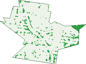
Green: 10 m cells where trees dominate, satellite 2021. Blue: water. The line is the suburb boundary.
| Canopy share, 1 m canopy height map, 2020 | 11.2% |
|---|---|
| Land with trees, 10 m satellite map, 2021 | 5.8% |
Demographics
Unemployment 6.5% · Labour-force participation 69.5%
Population by age in Woolloongabba
| 0-4 | 252 |
|---|---|
| 5-14 | 429 |
| 15-19 | 452 |
| 20-24 | 1,744 |
| 25-34 | 2,796 |
| 35-44 | 1,103 |
| 45-54 | 700 |
| 55-64 | 542 |
| 65-74 | 315 |
| 75-84 | 219 |
| 85+ | 142 |
Dwelling types in Woolloongabba
| House | 1,023 |
|---|---|
| Townhouse | 23 |
| Apartment | 2,382 |
| Other | 0 |
Households by weekly income in Woolloongabba
| <$650 | 504 |
|---|---|
| $650-1,499 | 794 |
| $1,500-2,999 | 1,124 |
| $3,000+ | 799 |
Top ancestries in Woolloongabba
| English | 2,374 |
|---|---|
| Australian | 1,850 |
| Other | 1,442 |
| Chinese | 1,175 |
| Irish | 959 |
| Scottish | 727 |
Housing tenure in Woolloongabba
| Owned | 339 |
|---|---|
| Mortgage | 566 |
| Rented | 2,386 |
| Other | 52 |
Cars per household in Woolloongabba
| 0 | 542 |
|---|---|
| 1 | 1,728 |
| 2 | 779 |
| 3 | 187 |
| 4+ | 105 |
Commute to work in Woolloongabba
| Car | 2,074 |
|---|---|
| Train | 129 |
| Bus | 564 |
| Tram/ferry | 4 |
| Walked | 424 |
| Bicycle | 152 |
| Home | 924 |
Top countries of birth in Woolloongabba
| China | 603 |
|---|---|
| New Zealand | 268 |
| India | 236 |
| England | 210 |
| South Korea | 173 |
| Vietnam | 128 |
Languages used at home in Woolloongabba
| Mandarin | 738 |
|---|---|
| Cantonese | 186 |
| Korean | 175 |
| Vietnamese | 172 |
| Spanish | 143 |
| Hindi | 97 |
Birds & Wildlife Nearby
294,794 bird observations recorded near Woolloongabba — most often seen:
- Noisy Miner (26,317)
- Torresian Crow (23,799)
- Rainbow Lorikeet (21,439)
- Australian White Ibis (15,690)
- Pied Currawong (15,204)
- Welcome Swallow (14,512)
- Grey Butcherbird (13,877)
- Australian Magpie (12,521)
- Scaly-breasted Lorikeet (10,782)
- Magpie-lark (10,761)
- Australian Brush-turkey (10,577)
- Pied Butcherbird (10,411)
- Australasian Figbird (10,066)
Show all 30 birds recorded near Woolloongabba
- Laughing Kookaburra (9,262)
- Dusky Moorhen (8,487)
- Rock Dove (6,376)
- Australian Wood Duck (6,374)
- Masked Lapwing (6,374)
- Willie Wagtail (6,348)
- Pacific Black Duck (6,346)
- Blue-faced Honeyeater (5,824)
- Bush Stone-curlew (5,466)
- Spotted Turtle-dove (5,211)
- Crested Pigeon (5,107)
- Little Corella (4,773)
- Australasian Darter (4,747)
- Sulphur-crested Cockatoo (4,704)
- Striated Pardalote (4,615)
- Tawny Frogmouth (4,545)
- Common Myna (4,279)
Sightings reported by observers, not a survey, so the counts show what people record rather than what lives here. Source: Atlas of Living Australia.
Nearby Suburbs
The closest suburbs to Woolloongabba:
- Stones Corner (1.1 km)
- Dutton Park (1.2 km)
- East Brisbane (1.3 km)
- Greenslopes (2 km)
- Fairfield (2 km)
- Kangaroo Point (2 km)
- Annerley (2.2 km)
- Highgate Hill (2.2 km)
Embed this suburb
Add this free Woolloongabba stat card to your own site — just copy the code:
Preview:
Cite this page
Quoting these figures? Copy the credit line:
Keep an eye on Woolloongabba
One email when this data meaningfully changes — new census figures, prices, rankings. No spam, unsubscribe anytime.
Streets
- Abingdon Street (91)
- Agnes Street (8)
- Albert Street (42)
- Albion Street (6)
- Allen Street (1)
- Annerley Road (154)
- Annie Street (13)
- Arne Street (12)
- Arrow Street (14)
- Atherton Street (12)
- Athlone Street (23)
- Balaclava Street (51)
- Bourne Street (9)
- Broadway Street (108)
- Bruce Street (14)
- Buranda Street (39)
- Burke Street (26)
- Carl Street (665)
- Catherine Street (32)
- Church Avenue (20)
- Churchill Street (19)
- Constance Street (1)
- Cornwall Street (59)
- Cowley Street (18)
- Derelle Street (1)
- Deshon Street (390)
- Dibley Street (15)
- Digger Street (3)
- Elliott Street (17)
- Ellis Street (1)
- Faversham Street (30)
- Fern Street (30)
- Fleurs Street (27)
- Flower Street (36)
- Gibbon Street (139)
- Gillingham Street (878)
- Gloucester Street (7)
- Grattan Street (15)
- Grove Street (3)
- Guy Street (8)
- Harrogate Street (38)
- Hawthorne Street (156)
- Heaslop Street (47)
- Henry Street (23)
- Holden Street (105)
- Hubert Street (159)
- Ipswich Road (356)
- Junction Street (13)
- Jurgens Street (50)
- Kent Street (2)
- Leamington Street (16)
- Leonard Street (57)
- Leopard Street (8)
- Lerna Street (1)
- Lewis Street (61)
- Line Street (15)
- Link Street (3)
- Lockhart Street (106)
- Logan Road (1,034)
- Longlands Street (5)
- Longwood Street (21)
- Lotus Street (11)
- Lower River Terrace (1)
- Lucinda Street (15)
- Main Street (29)
- Martin Street (13)
- Maynard Street (95)
- Merton Road (81)
- Morrissey Street (6)
- Mossgrove Street (21)
- Mountjoy Street (12)
- Myrtle Street (12)
- Nile Street (62)
- Norman Street (4)
- O'keefe Street (278)
- Oxford Street (25)
- Park Road (103)
- Peterson Street (37)
- Preston Street (26)
- Qualtrough Street (133)
- Quarry Street (13)
- Queen Bess Street (13)
- Railway Street (20)
- Redfern Street (44)
- Regent Street (454)
- Reid Street (24)
- Reis Street (38)
- Ross Street (86)
- Salisbury Street (51)
- School Road (3)
- School Street (8)
- South East Freeway (3)
- Stanely Street (1)
- Stanley Street (718)
- Sword Street (62)
- Taylor Street (129)
- Toohey Street (11)
- Tottenham Street (29)
- Trafalgar Street (209)
- Trinity Lane (29)
- Turbo Drive (4)
- Vanda Street (21)
- Vulture Street (10)
- Walker Street (9)
- Wellington Road (8)
- Wilton Street (150)
- Wolseley Street (229)