Kangaroo Point QLD 4169
9,201 addresses · 66 streets
Griffith Electorate › Brisbane LGA › Kangaroo Point · 1 km from Brisbane
📦 Thinking of moving here? Read the Kangaroo Point moving guide

Living Here
An inner-Brisbane peninsula suburb of riverside apartments beneath the cliffs across from the CBD, Kangaroo Point is dense and central. Households average 1.8 people and the median age is 36. Median household income is $2,058 a week, with rent around $450.
Kangaroo Point is a suburb of Queensland, home to about 9,689 people, with a median age of 36. The typical household earns around $2,058 a week, with median rent near $450 a week. Most homes are apartments. About 36% of households own their home and 63% rent. Most workers drive to work. Common community backgrounds include English, Australian, Irish. On the ABS socio-economic scale it sits in decile 10 of 10 nationally — a relatively advantaged area.
Over time — Census 2001 → 2021
Dashed line: district figures for the Kangaroo Point statistical area (SA2), the smallest area the ABS published before 2011. Solid line: Kangaroo Point itself.
Getting Around & Local Services
40 doctors & medical clinics
26 hospitals
Getting around. Train station: Brisbane Central, 1.6 km north-west · Bus interchange: Woolloongabba Station, 1.2 km south · Ferry wharf: Dockside Ferry Terminal, 400 m north-east · Airport: Brisbane Airport, 13.6 km north-east.
Socio-economic Standing
Deciles from 1 (lowest) to 10 (highest), against all Australian suburbs. The overall figure weighs advantage and disadvantage together; economic resources counts income and housing, and education & jobs counts qualifications and occupation. They often differ. Source: ABS SEIFA 2021.
Tree cover
🌳 Tree canopy: 16.3% share of land under canopy · satellite map, 2020
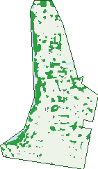
Green: 10 m cells where trees dominate, satellite 2021. Blue: water. The line is the suburb boundary.
| Canopy share, 1 m canopy height map, 2020 | 16.3% |
|---|---|
| Land with trees, 10 m satellite map, 2021 | 13.6% |
Demographics
Unemployment 5% · Labour-force participation 71.9%
Population by age in Kangaroo Point
| 0-4 | 256 |
|---|---|
| 5-14 | 334 |
| 15-19 | 278 |
| 20-24 | 1,061 |
| 25-34 | 2,617 |
| 35-44 | 1,475 |
| 45-54 | 1,128 |
| 55-64 | 1,083 |
| 65-74 | 838 |
| 75-84 | 434 |
| 85+ | 180 |
Dwelling types in Kangaroo Point
| House | 448 |
|---|---|
| Townhouse | 114 |
| Apartment | 4,073 |
| Other | 30 |
Households by weekly income in Kangaroo Point
| <$650 | 553 |
|---|---|
| $650-1,499 | 1,012 |
| $1,500-2,999 | 1,519 |
| $3,000+ | 1,311 |
Top ancestries in Kangaroo Point
| English | 3,365 |
|---|---|
| Australian | 2,214 |
| Other | 1,593 |
| Irish | 1,414 |
| Scottish | 1,091 |
| Ancestry NS | 697 |
Housing tenure in Kangaroo Point
| Owned | 871 |
|---|---|
| Mortgage | 815 |
| Rented | 2,909 |
| Other | 36 |
Cars per household in Kangaroo Point
| 0 | 564 |
|---|---|
| 1 | 2,472 |
| 2 | 1,232 |
| 3 | 247 |
| 4+ | 92 |
Commute to work in Kangaroo Point
| Car | 2,680 |
|---|---|
| Train | 21 |
| Bus | 357 |
| Tram/ferry | 172 |
| Walked | 428 |
| Bicycle | 166 |
| Home | 1,360 |
Top countries of birth in Kangaroo Point
| England | 431 |
|---|---|
| New Zealand | 364 |
| India | 160 |
| Philippines | 138 |
| Brazil | 122 |
| China | 122 |
Languages used at home in Kangaroo Point
| Spanish | 271 |
|---|---|
| Mandarin | 236 |
| Portuguese | 122 |
| Italian | 100 |
| Cantonese | 77 |
| French | 70 |
Birds & Wildlife Nearby
239,534 bird observations recorded near Kangaroo Point — most often seen:
- Noisy Miner (19,488)
- Torresian Crow (17,511)
- Rainbow Lorikeet (15,093)
- Australian White Ibis (14,978)
- Welcome Swallow (13,070)
- Australian Magpie (10,512)
- Magpie-lark (9,953)
- Pied Currawong (9,857)
- Grey Butcherbird (9,629)
- Australasian Figbird (9,109)
- Pied Butcherbird (8,662)
- Scaly-breasted Lorikeet (7,696)
- Australian Brush-turkey (7,406)
Show all 30 birds recorded near Kangaroo Point
- Dusky Moorhen (7,323)
- Rock Dove (6,304)
- Masked Lapwing (6,166)
- Laughing Kookaburra (5,677)
- Australian Wood Duck (5,479)
- Willie Wagtail (5,271)
- Pacific Black Duck (5,227)
- Bush Stone-curlew (5,218)
- Blue-faced Honeyeater (5,059)
- Spotted Turtle-dove (5,018)
- Crested Pigeon (4,632)
- Australasian Darter (4,607)
- Little Corella (4,400)
- Little Black Cormorant (4,221)
- Common Myna (4,108)
- Tree Martin (4,083)
- Australasian Purple Swamphen (3,777)
Sightings reported by observers, not a survey, so the counts show what people record rather than what lives here. Source: Atlas of Living Australia.
Nearby Suburbs
The closest suburbs to Kangaroo Point:
- East Brisbane (1.2 km)
- New Farm (1.2 km)
- Brisbane City (1.3 km)
- South Brisbane (1.9 km)
- Woolloongabba (2 km)
- Spring Hill (2 km)
- Fortitude Valley (2.1 km)
- Dutton Park (2.4 km)
Embed this suburb
Add this free Kangaroo Point stat card to your own site — just copy the code:
Preview:
Cite this page
Quoting these figures? Copy the credit line:
Keep an eye on Kangaroo Point
One email when this data meaningfully changes — new census figures, prices, rankings. No spam, unsubscribe anytime.
Streets
- Amesbury Street (3)
- Anderson Street (190)
- Anglesey Street (122)
- Annie Street (21)
- Baildon Street (240)
- Baines Street (127)
- Bell Street (113)
- Boundary Street (1)
- Bright Street (27)
- Bromley Street (87)
- Burke Lane (5)
- Cairns Street (111)
- Castlebar Street (252)
- Connor Street (40)
- Darragh Street (9)
- Deakin Street (212)
- Duke Street (177)
- Elliott Street (37)
- Ellis Street (78)
- End Street (1)
- Eve Street (5)
- Ferry Street (461)
- Goodwin Street (514)
- Grace Street (7)
- Hamilton Street (33)
- Hilderstone Street (1)
- Holman Street (166)
- Lahey Lane (2)
- Lambert Street (603)
- Leopard Street (71)
- Linton Street (466)
- Llewellyn Street (50)
- Lockerbie Street (57)
- Lower River Terrace (22)
- Macdonald Street (104)
- Mackenzie Street (3)
- Main Street (1,394)
- Mark Lane (24)
- Neville Street (18)
- O'connell Street (195)
- Oconnell Street (224)
- Paton Street (15)
- Pearson Street (105)
- Pixley Street (64)
- Princess Street (184)
- Prospect Street (5)
- Quinton Street (50)
- Rawlins Street (87)
- River Terrace (244)
- Rosina Street (46)
- Rotherham Street (118)
- Salstone Street (37)
- Scott Street (39)
- Shafston Avenue (756)
- Sinclair Street (43)
- Thomas Street (57)
- Thorn Street (532)
- Thornton Street (19)
- Thorton Street (16)
- Toohey Street (32)
- Vulture Street (126)
- Walmsley Street (20)
- Wellington Road (143)
- Wharf Street (134)
- Wicklow Street (52)
- Wild Street (4)