Fortitude Valley QLD 4006
13,423 addresses · 78 streets
Brisbane Electorate › Brisbane LGA › Fortitude Valley · 2 km from Brisbane
📦 Thinking of moving here? Read the Fortitude Valley moving guide

Living Here
An inner-Brisbane entertainment precinct known for its nightlife and music, Fortitude Valley is youthful and apartment-dense. Very small households of 1.6 people and a median age of 31 prevail. Median household income is $1,658 a week, with rent around $400.
Fortitude Valley is a suburb of Queensland, home to about 9,708 people, with a median age of 31. The typical household earns around $1,658 a week, with median rent near $400 a week. Most homes are apartments. About 18% of households own their home and 82% rent. Most workers drive to work. Common community backgrounds include English, Australian, Irish. On the ABS socio-economic scale it sits in decile 9 of 10 nationally — a relatively advantaged area.
Over time — Census 2001 → 2021
Dashed line: district figures for the Fortitude Valley statistical area (SA2), the smallest area the ABS published before 2011. Solid line: Fortitude Valley itself.
Getting Around & Local Services
1 beach
33 doctors & medical clinics
- Holdsworth House
- Central Brunswick Medical Centre
- Myhealth Brisbane Showgrounds
- Savage Xray
- Bowen Hills Medical Centre
- Herston Health
- Laser Sight
- Dermatology Specialist Center
- Queensland Sports Medical Centre
- Briz Brain & Spine
See all 33 doctors & medical clinics near Fortitude Valley →
26 hospitals
Getting around. Train station: Fortitude Valley, 100 m north-west · Bus interchange: RBW Hospital, 1.2 km north-west · Ferry wharf: Howard Smith Wharves Ferry Terminal, 800 m south · Airport: Brisbane Airport, 12.1 km north-east.
Socio-economic Standing
Deciles from 1 (lowest) to 10 (highest), against all Australian suburbs. The overall figure weighs advantage and disadvantage together; economic resources counts income and housing, and education & jobs counts qualifications and occupation. They often differ. Source: ABS SEIFA 2021.
Tree cover
🌳 Tree canopy: 5.5% share of land under canopy · satellite map, 2020
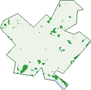
Green: 10 m cells where trees dominate, satellite 2021. Blue: water. The line is the suburb boundary.
| Canopy share, 1 m canopy height map, 2020 | 5.5% |
|---|---|
| Land with trees, 10 m satellite map, 2021 | 2.2% |
Demographics
Unemployment 5.4% · Labour-force participation 78.1%
Population by age in Fortitude Valley
| 0-4 | 204 |
|---|---|
| 5-14 | 216 |
| 15-19 | 191 |
| 20-24 | 1,467 |
| 25-34 | 3,943 |
| 35-44 | 1,804 |
| 45-54 | 902 |
| 55-64 | 520 |
| 65-74 | 266 |
| 75-84 | 120 |
| 85+ | 64 |
Dwelling types in Fortitude Valley
| House | 107 |
|---|---|
| Townhouse | 65 |
| Apartment | 5,061 |
| Other | 0 |
Households by weekly income in Fortitude Valley
| <$650 | 684 |
|---|---|
| $650-1,499 | 1,553 |
| $1,500-2,999 | 1,983 |
| $3,000+ | 813 |
Top ancestries in Fortitude Valley
| English | 2,947 |
|---|---|
| Other | 2,067 |
| Australian | 2,018 |
| Irish | 1,061 |
| Scottish | 862 |
| Ancestry NS | 839 |
Housing tenure in Fortitude Valley
| Owned | 261 |
|---|---|
| Mortgage | 664 |
| Rented | 4,230 |
| Other | 35 |
Cars per household in Fortitude Valley
| 0 | 1,507 |
|---|---|
| 1 | 2,922 |
| 2 | 633 |
| 3 | 66 |
| 4+ | 35 |
Commute to work in Fortitude Valley
| Car | 1,985 |
|---|---|
| Train | 372 |
| Bus | 467 |
| Tram/ferry | 7 |
| Walked | 1,383 |
| Bicycle | 109 |
| Home | 1,358 |
Top countries of birth in Fortitude Valley
| New Zealand | 403 |
|---|---|
| England | 325 |
| India | 306 |
| Brazil | 272 |
| China | 204 |
| Thailand | 179 |
Languages used at home in Fortitude Valley
| Spanish | 469 |
|---|---|
| Mandarin | 262 |
| Portuguese | 259 |
| Thai | 161 |
| Hindi | 124 |
| Korean | 124 |
Birds & Wildlife Nearby
164,732 bird observations recorded near Fortitude Valley — most often seen:
- Noisy Miner (13,294)
- Torresian Crow (11,987)
- Australian White Ibis (10,825)
- Rainbow Lorikeet (10,345)
- Welcome Swallow (9,047)
- Australian Magpie (7,354)
- Magpie-lark (7,033)
- Pied Currawong (7,014)
- Australasian Figbird (6,708)
- Grey Butcherbird (6,503)
- Pied Butcherbird (5,826)
- Rock Dove (5,746)
- Australian Brush-turkey (5,603)
Show all 30 birds recorded near Fortitude Valley
- Dusky Moorhen (5,169)
- Scaly-breasted Lorikeet (4,729)
- Laughing Kookaburra (4,469)
- Bush Stone-curlew (4,388)
- Masked Lapwing (3,759)
- Blue-faced Honeyeater (3,704)
- Willie Wagtail (3,492)
- Spotted Turtle-dove (3,432)
- Tree Martin (3,207)
- Crested Pigeon (3,088)
- Pacific Black Duck (3,053)
- Sulphur-crested Cockatoo (2,821)
- Common Myna (2,626)
- Australian Wood Duck (2,555)
- Australasian Darter (2,428)
- Silver Gull (2,365)
- Little Corella (2,162)
Sightings reported by observers, not a survey, so the counts show what people record rather than what lives here. Source: Atlas of Living Australia.
Nearby Suburbs
The closest suburbs to Fortitude Valley:
- Bowen Hills (0.9 km)
- Newstead (1.1 km)
- Spring Hill (1.2 km)
- Teneriffe (1.3 km)
- New Farm (1.5 km)
- Brisbane City (1.6 km)
- Herston (1.8 km)
- Kangaroo Point (2.1 km)
Embed this suburb
Add this free Fortitude Valley stat card to your own site — just copy the code:
Preview:
Cite this page
Quoting these figures? Copy the credit line:
Keep an eye on Fortitude Valley
One email when this data meaningfully changes — new census figures, prices, rankings. No spam, unsubscribe anytime.
Streets
- Agnes Street (85)
- Alden Street (1)
- Alfred Street (1,360)
- Amelia Street (55)
- Anderson Street (138)
- Ann Street (1,522)
- Arthur Street (354)
- Ballow Street (49)
- Barry Parade (145)
- Baxter Street (41)
- Berwick Street (220)
- Bonney Lane (140)
- Boundary Street (20)
- Bowen Terrace (212)
- Brewers Street (1)
- Bridge Street (9)
- Brookes Street (269)
- Brooks Street (1)
- Brunswick Street (1,703)
- Chester Street (6)
- Church Street (227)
- Coniston Lane (1)
- Connor Street (238)
- Constance Street (81)
- Costin Street (32)
- Diggles Close (2)
- Dodge Lane (1)
- Doggett Street (98)
- Duncan Street (67)
- East Street (3)
- Esther Street (2)
- Gipps Street (119)
- Gotha Street (706)
- Green Square Close (97)
- Gregory Terrace (161)
- Grenier Street (2)
- Harcourt Street (9)
- Hynes Street (48)
- Ivory Lane (13)
- Ivory Street (1)
- James Street (275)
- Julia Street (10)
- Kemp Place (7)
- Kennigo Street (2)
- Knapp Street (9)
- Light Street (49)
- Little Street (10)
- Love Street (3)
- Lucky Lane (1)
- Malt Street (93)
- Marshall Street (3)
- Martin Street (58)
- Mclachlan Street (406)
- Misterton Street (16)
- Montpelier Road (2)
- Moray Street (3)
- Morgan Street (11)
- Murri Way (5)
- Overells Lane (1)
- Prospect Street (99)
- Quarry Street (1)
- Ranwell Lane (4)
- Robertson Street (661)
- Rosetta Street (44)
- Saint Pauls Terrace (555)
- Scanlan Street (2)
- School Street (1)
- St Pauls Terrace (557)
- Symes Street (8)
- Trinity Street (213)
- Wandoo Street (110)
- Warner Street (151)
- Warren Street (33)
- Warry Street (201)
- Water Street (399)
- Wickham Street (1,173)
- Winn Street (7)
- Yeovil Street (1)