Coopers Plains QLD 4108
4,137 addresses · 94 streets
Moreton Electorate › Brisbane LGA › Coopers Plains · 11 km from Brisbane
📦 Thinking of moving here? Read the Coopers Plains moving guide

Living Here
Coopers Plains is a suburb of Queensland, home to about 5,675 people, with a median age of 33. The typical household earns around $1,593 a week, with median rent near $369 a week. Most homes are houses. About 50% of households own their home and 50% rent. Most workers drive to work. Common community backgrounds include English, Australian, Chinese. On the ABS socio-economic scale it sits in decile 6 of 10 nationally — a mid-range area.
Over time — Census 2001 → 2021
Dashed line: district figures for the Coopers Plains statistical area (SA2), the smallest area the ABS published before 2011. Solid line: Coopers Plains itself.
Getting Around & Local Services
2 dentists
1 physiotherapist
4 optometrists
11 childcare & kindergartens
- Life Early Learning Centre
- Goodstart Early Learning Coopers Plains
- Guardian Childcare & Education Coopers Plains
- Tzu Chi Early Learning Centre
- Goodstart Early Learning Robertson
- C&K Salisbury Community Kindergarten
- Footprints Sunnybank Child Care Centre
- Sunnybank Community Preschool and Kindergarten
- Guppy's Early Learning Centre - Acacia Ridge
- Avenues Montessori Children's House
1 playground
2 dog parks
2 bakeries
2 butchers
1 beauty salon
Getting around. Train station: Coopers Plains, 300 m west · Bus interchange: Griffith University, 3.4 km north-east · Airport: Brisbane Airport, 22.4 km north.
Socio-economic Standing
Deciles from 1 (lowest) to 10 (highest), against all Australian suburbs. The overall figure weighs advantage and disadvantage together; economic resources counts income and housing, and education & jobs counts qualifications and occupation. They often differ. Source: ABS SEIFA 2021.
Tree cover
🌳 Tree canopy: 13.3% share of land under canopy · satellite map, 2020
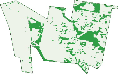
Green: 10 m cells where trees dominate, satellite 2021. Blue: water. The line is the suburb boundary.
| Canopy share, 1 m canopy height map, 2020 | 13.3% |
|---|---|
| Land with trees, 10 m satellite map, 2021 | 15.3% |
Demographics
Unemployment 7.6% · Labour-force participation 63.3%
Population by age in Coopers Plains
| 0-4 | 315 |
|---|---|
| 5-14 | 523 |
| 15-19 | 244 |
| 20-24 | 520 |
| 25-34 | 1,365 |
| 35-44 | 872 |
| 45-54 | 593 |
| 55-64 | 493 |
| 65-74 | 389 |
| 75-84 | 264 |
| 85+ | 83 |
Dwelling types in Coopers Plains
| House | 1,571 |
|---|---|
| Townhouse | 227 |
| Apartment | 270 |
| Other | 0 |
Households by weekly income in Coopers Plains
| <$650 | 331 |
|---|---|
| $650-1,499 | 584 |
| $1,500-2,999 | 661 |
| $3,000+ | 356 |
Top ancestries in Coopers Plains
| English | 1,170 |
|---|---|
| Australian | 1,144 |
| Other | 1,143 |
| Chinese | 931 |
| Indian | 552 |
| Irish | 378 |
Housing tenure in Coopers Plains
| Owned | 465 |
|---|---|
| Mortgage | 556 |
| Rented | 1,018 |
| Other | 16 |
Cars per household in Coopers Plains
| 0 | 209 |
|---|---|
| 1 | 829 |
| 2 | 697 |
| 3 | 198 |
| 4+ | 118 |
Commute to work in Coopers Plains
| Car | 1,737 |
|---|---|
| Train | 94 |
| Bus | 129 |
| Tram/ferry | 0 |
| Walked | 41 |
| Bicycle | 21 |
| Home | 365 |
Top countries of birth in Coopers Plains
| India | 568 |
|---|---|
| China | 372 |
| Philippines | 201 |
| Taiwan | 155 |
| Vietnam | 128 |
| New Zealand | 123 |
Languages used at home in Coopers Plains
| Mandarin | 614 |
|---|---|
| Gujarati | 277 |
| Cantonese | 212 |
| Vietnamese | 158 |
| Hindi | 104 |
| Tagalog | 101 |
Birds & Wildlife Nearby
94,900 bird observations recorded near Coopers Plains — most often seen:
- Noisy Miner (9,717)
- Torresian Crow (8,769)
- Rainbow Lorikeet (8,600)
- Pied Currawong (7,073)
- Grey Butcherbird (6,307)
- Laughing Kookaburra (4,953)
- Australian Brush-turkey (4,324)
- Scaly-breasted Lorikeet (3,578)
- Australian Magpie (3,385)
- Tawny Frogmouth (2,920)
- Striated Pardalote (2,798)
- Pied Butcherbird (2,526)
- Noisy Friarbird (2,430)
Show all 30 birds recorded near Coopers Plains
- Australian White Ibis (2,210)
- Pale-headed Rosella (2,180)
- Welcome Swallow (2,080)
- Magpie-lark (1,982)
- Black-faced Cuckoo-shrike (1,793)
- Crested Pigeon (1,691)
- Willie Wagtail (1,645)
- Pacific Black Duck (1,544)
- Grey Fantail (1,513)
- Australasian Figbird (1,501)
- Dusky Moorhen (1,428)
- Rainbow Bee-eater (1,427)
- Brown Honeyeater (1,375)
- Galah (1,315)
- Grey Shrike-thrush (1,302)
- Silvereye (1,273)
- Spangled Drongo (1,261)
Sightings reported by observers, not a survey, so the counts show what people record rather than what lives here. Source: Atlas of Living Australia.
Nearby Suburbs
The closest suburbs to Coopers Plains:
- Robertson (1.7 km)
- Salisbury (1.7 km)
- Archerfield (2.1 km)
- Sunnybank (2.4 km)
- Acacia Ridge (2.6 km)
- Nathan (2.6 km)
- Rocklea (3.3 km)
- Sunnybank Hills (3.4 km)
Embed this suburb
Add this free Coopers Plains stat card to your own site — just copy the code:
Preview:
Cite this page
Quoting these figures? Copy the credit line:
Keep an eye on Coopers Plains
One email when this data meaningfully changes — new census figures, prices, rankings. No spam, unsubscribe anytime.
Streets
- Ada Street (23)
- Aesop Street (1)
- Allarton Street (28)
- Alton Street (20)
- Annie Street (64)
- Appleyard Crescent (42)
- Arrunga Street (14)
- Atkinson Close (9)
- Augstein Street (36)
- Aylton Street (25)
- Babbidge Street (39)
- Barham Street (22)
- Baroda Street (53)
- Barrett Street (1)
- Beaton Street (32)
- Beaudesert Road (119)
- Beechcroft Street (14)
- Beenleigh Road (25)
- Bishop Place (4)
- Bland Street (104)
- Bosworth Street (16)
- Boundary Road (251)
- Boundary Street (19)
- Bovey Street (38)
- Boyland Avenue (143)
- Breton Street (66)
- Celtic Street (25)
- Chotai Place (11)
- Clinton Street (21)
- Comer Street (111)
- Cottonvale Street (14)
- Cowper Place (16)
- Cricket Street (13)
- D'amour Place (9)
- Daisy Street (11)
- Dalveen Street (8)
- Dartmouth Street (88)
- Deacon Street (36)
- Deal Street (4)
- Debra Street (36)
- Delph Street (25)
- Dickinson Close (2)
- Dyson Avenue (1)
- Edith Street (29)
- Erathema Place (23)
- Eveline Street (4)
- Evenwood Street (49)
- Ferguson Place (26)
- Gay Street (21)
- Hammersmith Street (105)
- Harford Street (12)
- Henley Street (19)
- Highgate Street (97)
- Joyce Street (32)
- Kain Street (17)
- Keeling Street (46)
- Kessels Road (1)
- Lensworth Street (58)
- Leven Street (27)
- Lewis Street (15)
- Linneman Close (2)
- Longden Street (67)
- Low Street (2)
- Macdevitt Street (31)
- Macgroarty Street (188)
- Macknish Crescent (63)
- Mandarin Street (21)
- Mandell Close (7)
- Mckoy Street (30)
- Meadow Avenue (92)
- Middle Street (63)
- Mossop Street (2)
- Mullins Street (14)
- Musgrave Road (450)
- Norbury Street (15)
- Nyleta Street (113)
- Oban Street (14)
- Orange Grove Road (115)
- Peringa Street (19)
- Postle Street (15)
- Riawena Road (2)
- Richland Avenue (83)
- Rockvale Street (11)
- Rookwood Avenue (31)
- Rosedale Street (70)
- Selhurst Street (67)
- Sway Street (10)
- The Village Avenue (42)
- Thulimbah Street (9)
- Troughton Road (113)
- Turton Street (83)
- Upwood Street (18)
- Vereker Street (26)
- Weaver Street (29)