Maida Vale WA 6057
1,997 addresses · 110 streets
Swan Electorate › Kalamunda LGA › Maida Vale · 15 km from Perth
📦 Thinking of moving here? Read the Maida Vale moving guide

Living Here
Maida Vale is a suburb of Western Australia, home to about 4,499 people, with a median age of 42. The typical household earns around $1,977 a week, with median rent near $400 a week. Most homes are houses. About 87% of households own their home and 12% rent. Most workers drive to work. Common community backgrounds include English, Australian, Irish. On the ABS socio-economic scale it sits in decile 7 of 10 nationally — a mid-range area.
Over time — Census 2001 → 2021
Dashed line: district figures for the Kalamunda - Maida Vale - Gooseberry Hill statistical area (SA2), the smallest area the ABS published before 2011. Solid line: Maida Vale itself.
Getting Around & Local Services
4 cafés & restaurants
1 pharmacy
1 medical clinic
1 optometrist
2 libraries
2 post offices
6 service stations
3 gyms & sports centres
1 dog park
2 bakeries
3 hardware stores
1 hairdresser
2 mechanics
1 electrician
1 place to stay
Getting around. Train station: High Wycombe, 2.9 km west · Metro station: Airport Central, 4.6 km west · Bus interchange: Long Term Parking B Bus Transfer, 6.8 km west · Airport: Perth Airport, 5.8 km west.
Socio-economic Standing
Deciles from 1 (lowest) to 10 (highest), against all Australian suburbs. The overall figure weighs advantage and disadvantage together; economic resources counts income and housing, and education & jobs counts qualifications and occupation. They often differ. Source: ABS SEIFA 2021.
Tree cover
🌳 Tree canopy: 25% share of land under canopy · satellite map, 2020
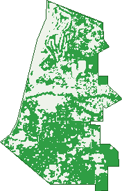
Green: 10 m cells where trees dominate, satellite 2021. Blue: water. The line is the suburb boundary.
| Canopy share, 1 m canopy height map, 2020 | 25.0% |
|---|---|
| Land with trees, 10 m satellite map, 2021 | 59.4% |
Demographics
Unemployment 4% · Labour-force participation 65.2%
Population by age in Maida Vale
| 0-4 | 244 |
|---|---|
| 5-14 | 566 |
| 15-19 | 287 |
| 20-24 | 234 |
| 25-34 | 525 |
| 35-44 | 525 |
| 45-54 | 636 |
| 55-64 | 652 |
| 65-74 | 525 |
| 75-84 | 230 |
| 85+ | 79 |
Dwelling types in Maida Vale
| House | 1,593 |
|---|---|
| Townhouse | 21 |
| Apartment | 11 |
| Other | 10 |
Households by weekly income in Maida Vale
| <$650 | 186 |
|---|---|
| $650-1,499 | 368 |
| $1,500-2,999 | 498 |
| $3,000+ | 398 |
Top ancestries in Maida Vale
| English | 2,036 |
|---|---|
| Australian | 1,706 |
| Irish | 454 |
| Scottish | 447 |
| Other | 368 |
| Italian | 306 |
Housing tenure in Maida Vale
| Owned | 617 |
|---|---|
| Mortgage | 783 |
| Rented | 202 |
| Other | 15 |
Cars per household in Maida Vale
| 0 | 26 |
|---|---|
| 1 | 397 |
| 2 | 650 |
| 3 | 293 |
| 4+ | 249 |
Commute to work in Maida Vale
| Car | 1,586 |
|---|---|
| Train | 10 |
| Bus | 47 |
| Tram/ferry | 0 |
| Walked | 16 |
| Bicycle | 5 |
| Home | 189 |
Top countries of birth in Maida Vale
| England | 377 |
|---|---|
| New Zealand | 146 |
| India | 51 |
| Scotland | 51 |
| South Africa | 45 |
| Italy | 38 |
Languages used at home in Maida Vale
| Italian | 47 |
|---|---|
| Mandarin | 22 |
| Thai | 19 |
| Afrikaans | 18 |
| German | 17 |
| French | 15 |
Birds & Wildlife Nearby
39,021 bird observations recorded near Maida Vale — most often seen:
- Twenty-eight Parrot (2,417)
- South-western Australian Magpie (2,348)
- Western Brown Honeyeater (2,025)
- Red-capped Parrot (1,786)
- Western Australian Raven (1,625)
- South-western Singing Honeyeater (1,583)
- Australian Ringneck (1,541)
- Laughing Turtle-dove (1,495)
- Australian Raven (1,472)
- Brown Honeyeater (1,467)
- Western Galah (1,446)
- Common Bronzewing (1,311)
- Galah (1,252)
Show all 30 birds recorded near Maida Vale
- Singing Honeyeater (1,220)
- Western Silvereye (1,168)
- Willie Wagtail (1,156)
- Western Red Wattlebird (1,124)
- White-cheeked Honeyeater (1,107)
- South-western New Holland Honeyeater (1,093)
- Western Striated Pardalote (1,050)
- Australian Magpie (1,044)
- New Holland Honeyeater (1,032)
- Pacific Black Duck (962)
- Rainbow Lorikeet (945)
- South-western Grey Fantail (931)
- Southern Magpie-lark (921)
- Eastern Asian Spotted Dove (920)
- Southern Laughing Kookaburra (912)
- Red Wattlebird (873)
- Southern Rufous Whistler (795)
Sightings reported by observers, not a survey, so the counts show what people record rather than what lives here. Source: Atlas of Living Australia.
Nearby Suburbs
The closest suburbs to Maida Vale:
- High Wycombe (2.3 km)
- Gooseberry Hill (2.4 km)
- Bushmead (3 km)
- Forrestfield (3.6 km)
- Kalamunda (3.9 km)
- Helena Valley (4.2 km)
- Boya (5 km)
- Hazelmere (5.1 km)
Embed this suburb
Add this free Maida Vale stat card to your own site — just copy the code:
Preview:
Cite this page
Quoting these figures? Copy the credit line:
Keep an eye on Maida Vale
One email when this data meaningfully changes — new census figures, prices, rankings. No spam, unsubscribe anytime.
Streets
- Acacia Road (26)
- Agate Way (5)
- Almondtree Lane (8)
- Amber Court (10)
- Amethyst Place (22)
- Arundel Court (4)
- Babbler Court (21)
- Bandin Place (16)
- Baza Gardens (37)
- Berry Drive (24)
- Beryl Close (6)
- Billara Street (5)
- Bittern Close (11)
- Boona Court (5)
- Booralie Way (24)
- Brenda Road (14)
- Brewer Road (30)
- Bridle Drive (23)
- Bruce Road (16)
- Bugendore Street (39)
- Burran Court (7)
- Casuarina Road (31)
- Charles Street (12)
- Cherry Grove (7)
- Clovelly Court (7)
- Cootamundra Way (18)
- Crump Lane (5)
- Dampiera Court (7)
- Darter Way (11)
- David Street (77)
- Donald Road (6)
- Emerald Court (26)
- Eucalyptus Way (8)
- Gem Court (4)
- Gilba Place (12)
- Gooseberry Hill Road (43)
- Gordon Street (7)
- Gumnut Close (8)
- Harold Road (9)
- Hawkvalley Crescent (26)
- Hawtin Road (60)
- Hewson Place (10)
- Hibbertia Court (7)
- Holmes Road (40)
- Honeydew Close (5)
- Irwin Place (13)
- Jasmin Court (4)
- Jasmin Way (16)
- Jecks Street (14)
- Jubata Court (17)
- Kalamunda Road (97)
- Kaoriki Court (12)
- Kathleen Close (21)
- Kent Road (10)
- Kumal Court (6)
- Kunzea Close (13)
- Laurena Place (3)
- Lemontree Grove (7)
- Leschenaultia Way (15)
- Lilian Road (35)
- Lychee Way (25)
- Maida Vale Road (78)
- Matuka Mews (38)
- Maud Road (24)
- Mccormack Place (5)
- Meloway Drive (45)
- Midland Road (20)
- Millson Road (19)
- Moonglow Rise (6)
- Mulberry Court (5)
- Myerson Crescent (63)
- Netley Road (1)
- Norwood Road (33)
- Old Maida Vale Road (32)
- Opal Court (4)
- Oxford Court (16)
- Pearl Court (9)
- Pimelea Street (19)
- Pinker Crescent (34)
- Priory Road (27)
- Quenington Court (6)
- Ravenswood Road (14)
- Rhodes Place (11)
- Ridge Hill Road (19)
- Rosea Close (14)
- Ruby Way (17)
- Russell Road (17)
- Saddleback Circle (13)
- Sadler Drive (17)
- Sapphire Way (12)
- Scenic Drive (38)
- Shadytree Lane (7)
- Stanley Street (10)
- Sultana Road E (13)
- Sunrise Heights (11)
- Tambulan Road (17)
- Terrigal Place (12)
- Tingle Close (13)
- Tree Fern Green (11)
- Verdin Close (5)
- Warren Road (23)
- Watsonia Road (15)
- West Terrace (20)
- Willerin Mews (13)
- Willow Way (1)
- Woodland Grove (7)
- Woronora Close (18)
- Worralda Street (14)
- Yirrdah Court (11)
- Zircon Place (13)