Forrestfield WA 6058
7,030 addresses · 221 streets
Swan Electorate › Kalamunda LGA › Forrestfield · 14 km from Perth
📦 Thinking of moving here? Read the Forrestfield moving guide

Living Here
Forrestfield is a suburb of Western Australia, home to about 13,181 people, with a median age of 38. The typical household earns around $1,614 a week, with median rent near $350 a week. Most homes are houses. About 74% of households own their home and 23% rent. Most workers drive to work. Common community backgrounds include English, Australian, Irish. On the ABS socio-economic scale it sits in decile 4 of 10 nationally — a mid-range area.
Over time — Census 2001 → 2021
Dashed line: district figures for the Forrestfield - Wattle Grove statistical area (SA2), the smallest area the ABS published before 2011. Solid line: Forrestfield itself.
Getting Around & Local Services
6 cafés & restaurants
4 supermarkets
1 beach
2 pharmacies
1 medical clinic
1 optometrist
1 childcare centre
1 post office
1 playground
1 dog park
1 bakery
1 hairdresser
1 beauty salon
1 mechanic
1 electrician
1 place to stay
Getting around. Train station: High Wycombe, 3.6 km north-west · Metro station: Airport Central, 5.4 km north-west · Bus interchange: Welshpool Bus Depot (Lost property Transperth), 7 km west · Airport: Perth Airport, 6.2 km north-west.
Socio-economic Standing
Deciles from 1 (lowest) to 10 (highest), against all Australian suburbs. The overall figure weighs advantage and disadvantage together; economic resources counts income and housing, and education & jobs counts qualifications and occupation. They often differ. Source: ABS SEIFA 2021.
Tree cover
🌳 Tree canopy: 14.3% share of land under canopy · satellite map, 2020
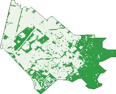
Green: 10 m cells where trees dominate, satellite 2021. Blue: water. The line is the suburb boundary.
| Canopy share, 1 m canopy height map, 2020 | 14.3% |
|---|---|
| Land with trees, 10 m satellite map, 2021 | 38.5% |
Demographics
Unemployment 5.5% · Labour-force participation 63.6%
Population by age in Forrestfield
| 0-4 | 849 |
|---|---|
| 5-14 | 1,644 |
| 15-19 | 692 |
| 20-24 | 774 |
| 25-34 | 1,856 |
| 35-44 | 1,942 |
| 45-54 | 1,638 |
| 55-64 | 1,505 |
| 65-74 | 1,352 |
| 75-84 | 665 |
| 85+ | 267 |
Dwelling types in Forrestfield
| House | 4,511 |
|---|---|
| Townhouse | 462 |
| Apartment | 9 |
| Other | 111 |
Households by weekly income in Forrestfield
| <$650 | 804 |
|---|---|
| $650-1,499 | 1,329 |
| $1,500-2,999 | 1,602 |
| $3,000+ | 841 |
Top ancestries in Forrestfield
| English | 5,323 |
|---|---|
| Australian | 4,401 |
| Other | 1,754 |
| Irish | 1,152 |
| Scottish | 1,121 |
| Ancestry NS | 717 |
Housing tenure in Forrestfield
| Owned | 1,409 |
|---|---|
| Mortgage | 2,317 |
| Rented | 1,131 |
| Other | 153 |
Cars per household in Forrestfield
| 0 | 205 |
|---|---|
| 1 | 1,682 |
| 2 | 1,999 |
| 3 | 703 |
| 4+ | 428 |
Commute to work in Forrestfield
| Car | 4,766 |
|---|---|
| Train | 13 |
| Bus | 158 |
| Tram/ferry | 0 |
| Walked | 58 |
| Bicycle | 9 |
| Home | 315 |
Top countries of birth in Forrestfield
| England | 880 |
|---|---|
| New Zealand | 553 |
| India | 323 |
| Philippines | 255 |
| South Africa | 155 |
| Afghanistan | 150 |
Languages used at home in Forrestfield
| Tagalog | 123 |
|---|---|
| Hindi | 115 |
| Mandarin | 112 |
| Filipino | 82 |
| Punjabi | 79 |
| Italian | 66 |
Birds & Wildlife Nearby
37,182 bird observations recorded near Forrestfield — most often seen:
- Twenty-eight Parrot (1,919)
- Western Brown Honeyeater (1,843)
- Red-capped Parrot (1,672)
- South-western Australian Magpie (1,634)
- South-western Singing Honeyeater (1,610)
- Forest Red-tailed Black-cockatoo (1,500)
- Laughing Turtle-dove (1,403)
- Western Australian Raven (1,370)
- Pacific Black Duck (1,351)
- South-western New Holland Honeyeater (1,301)
- Western Galah (1,296)
- Brown Honeyeater (1,282)
- Western Silvereye (1,278)
Show all 30 birds recorded near Forrestfield
- Common Bronzewing (1,254)
- Australian Raven (1,242)
- Eurasian Coot (1,148)
- Eastern Asian Spotted Dove (1,138)
- New Holland Honeyeater (1,137)
- Western Red Wattlebird (1,114)
- Galah (1,103)
- Australian Ringneck (1,070)
- Eastern Rainbow Lorikeet (1,044)
- Southern Willie Wagtail (1,004)
- Dusky Moorhen (978)
- Grey Teal (923)
- Southern Rufous Whistler (918)
- Rainbow Lorikeet (916)
- Australian White Ibis (912)
- Silvereye (912)
- Australian Magpie (910)
Sightings reported by observers, not a survey, so the counts show what people record rather than what lives here. Source: Atlas of Living Australia.
Nearby Suburbs
The closest suburbs to Forrestfield:
- Wattle Grove (2.6 km)
- Maida Vale (3.6 km)
- Lesmurdie (4.5 km)
- Kalamunda (4.5 km)
- High Wycombe (4.8 km)
- Orange Grove (4.9 km)
- Gooseberry Hill (5 km)
- East Cannington (5.8 km)
Embed this suburb
Add this free Forrestfield stat card to your own site — just copy the code:
Preview:
Cite this page
Quoting these figures? Copy the credit line:
Keep an eye on Forrestfield
One email when this data meaningfully changes — new census figures, prices, rankings. No spam, unsubscribe anytime.
Streets
- Abercorn Road (45)
- Abernethy Road (29)
- Acer Court (4)
- Acorn Close (7)
- Agati Place (12)
- Agincourt Drive (110)
- Agonis Place (18)
- Akebia Way (48)
- Albizia Close (50)
- Alder Way (2)
- Allamanda Way (50)
- Almond Way (25)
- Anderson Road (56)
- Annato Place (14)
- Anther Approach (15)
- Apple Way (6)
- Apricot Street (46)
- Aralia Way (50)
- Ardisia Court (7)
- Ashby Close (7)
- Aspen Court (8)
- Auburn Lane (7)
- Autumn Approach (7)
- Azalea Gardens (28)
- Azurite Court (14)
- Bain Square (44)
- Bardook Gardens (29)
- Bauhinia Road (28)
- Beaufortia Street (4)
- Bedford Crescent (14)
- Begonia Way (33)
- Berberis Way (47)
- Berkshire Road (437)
- Blackbutt Way (27)
- Blossom View (11)
- Bombax Lane (10)
- Boodjera Bend (36)
- Bougainvillea Avenue (96)
- Bristol Way (1)
- Briza Lane (34)
- Burtonia Way (46)
- Calcite Place (29)
- Calliandra Way (35)
- Calluna Way (78)
- Cambridge Road (31)
- Camellia Loop (28)
- Canopy Circuit (31)
- Cantua Way (44)
- Carissa Way (53)
- Carleton Crescent (22)
- Carolyn Way (5)
- Castle Court (10)
- Cedar Way (60)
- Chancery Court (13)
- Cherrytree Road (16)
- Chester Court (7)
- Citrine Gardens (29)
- Claire Street (6)
- Coburg Street (14)
- Connaught Street (52)
- Connor Road (11)
- Coolabah Way (41)
- Coronilla Way (45)
- Covelline Place (11)
- Crimson Boulevard (106)
- Cumberland Road (39)
- Cumquat Way (7)
- Cypress Road (69)
- Dawson Avenue (135)
- Diosma Way (52)
- Dorchester Road (29)
- Dubs Close (2)
- Dundas Road (35)
- Durham Way (17)
- Edinburgh Road (64)
- Essex Street (40)
- Evergreen Grove (56)
- Fagin Way (44)
- Falls Road (2)
- Ficus Lane (11)
- Fife Street (11)
- Fig Lane (6)
- Fruit Tree Crescent (85)
- Gala Way (42)
- Gilmore Place (13)
- Gimlet Court (20)
- Gotha Way (51)
- Guava Court (7)
- Hakea Court (6)
- Hale Road (311)
- Hanover Street (8)
- Hardey East Road (2)
- Harewood Street (32)
- Harrison Road (29)
- Hartfield Road (104)
- Hawtin Road (115)
- Helidor Place (7)
- Hibiscus Drive (31)
- Hicks Street (19)
- Hillary Place (3)
- Hollybush Court (8)
- Holmes Road (139)
- Honey Road (9)
- Hood Street (5)
- Hove Court (13)
- Ilex Way (30)
- Jacobina Way (49)
- Jubilee Road (24)
- Juniper Way (48)
- Kalil Fairway (11)
- Kalmia Way (44)
- Karlak Circuit (45)
- Koda Mews (7)
- Korad Terrace (14)
- Kunzite Court (15)
- Larch Place (11)
- Larix Way (19)
- Laurel Street (14)
- Lee Street (6)
- Leiden Place (30)
- Lewis Road (133)
- Limonite Court (20)
- Lincoln Road (44)
- Linden Way (42)
- Lomatia Way (29)
- Loquat Way (9)
- Lovett Drive (57)
- Lyonia Court (13)
- Magnolia Way (52)
- Mahonia Way (42)
- Mallee Way (44)
- Mallow Way (36)
- Malo Link (15)
- Mandon Street (30)
- Mangosteen Drive (27)
- Marble Place (41)
- Marlock Court (10)
- Maya Crescent (15)
- Menangal Way (9)
- Milner Road (2)
- Mimosa Street (5)
- Mineral Place (16)
- Moira Avenue (62)
- Moonbooli Street (13)
- Morris Drive (39)
- Morrison Road (8)
- Nandat Road (9)
- Nardine Close (6)
- Nectarine Way (15)
- Norfolk Street (13)
- Northumberland Road (28)
- Oak Court (24)
- Ozone Terrace (4)
- Palm Terrace (25)
- Passiflora Drive (32)
- Passionfruit Way (23)
- Passmore Way (6)
- Pavetta Crescent (71)
- Peach Tree Way (34)
- Pear Close (4)
- Pearce Avenue (22)
- Pine Court (9)
- Pinebrook Gardens (12)
- Pistacia Road (15)
- Plane Tree Green (24)
- Platinum Way (21)
- Plum Way (6)
- Poplar Court (10)
- Preece Court (18)
- Pumice Court (19)
- Pyrite Court (28)
- Pyrus Way (33)
- Quartz Lane (4)
- Quince Way (16)
- Reynolds Road (75)
- Rodgers Close (6)
- Rothesay Street (5)
- Salix Way (44)
- Sentosa Drive (25)
- Setosa Drive (62)
- Seville Road (24)
- Sheoak Court (16)
- Silk Chase (22)
- Solandra Way (60)
- Somerset Street (12)
- Sorbus Lane (10)
- Sorrel Court (11)
- Sovereign Place (29)
- Spinosa Boulevard (21)
- Strathearn Road (22)
- Strawberry Way (16)
- Strelitzia Avenue (124)
- Stringybark Drive (41)
- Sultana Road E (56)
- Sussex Road (127)
- Tallerack Way (37)
- Tarata Way (33)
- The Citadel (9)
- The Retreat (9)
- Tillia Court (8)
- Tourmaline Gardens (25)
- Trona Place (9)
- Tungsten Court (17)
- Turquoise Court (14)
- Tyler Mews (9)
- Vinca Way (42)
- Virgilia Way (48)
- Wales Street (13)
- Walters Way (17)
- Wandoo Road (28)
- Warda Crescent (33)
- Waterfall Road (20)
- Webster Road (1)
- Whistlepipe Court (9)
- Wisteria Court (8)
- Wonderboom Way (35)
- Woodlupine Court (24)
- Yabera Road (12)
- Yate Place (8)
- Yongar Way (8)
- York Street (18)