Kalamunda WA 6076
4,104 addresses · 152 streets
Hasluck Electorate › Kalamunda LGA › Kalamunda · 18 km from Perth
📦 Thinking of moving here? Read the Kalamunda moving guide

Living Here
Kalamunda is a suburb of Western Australia, home to about 7,163 people, with a median age of 49. The typical household earns around $1,622 a week, with median rent near $360 a week. Most homes are houses. About 84% of households own their home and 15% rent. Most workers drive to work. Common community backgrounds include English, Australian, Scottish. On the ABS socio-economic scale it sits in decile 9 of 10 nationally — a relatively advantaged area.
Over time — Census 2001 → 2021
Dashed line: district figures for the Kalamunda - Maida Vale - Gooseberry Hill statistical area (SA2), the smallest area the ABS published before 2011. Solid line: Kalamunda itself.
Getting Around & Local Services
1 medical clinic
1 dentist
1 optometrist
3 childcare & kindergartens
2 libraries
4 service stations
3 gyms & sports centres
1 playground
1 dog park
1 bakery
2 butchers
2 hardware stores
1 mechanic
1 electrician
1 place to stay
Getting around. Train station: High Wycombe, 6.4 km west · Airport: Perth Airport, 9.4 km west.
Socio-economic Standing
Deciles from 1 (lowest) to 10 (highest), against all Australian suburbs. The overall figure weighs advantage and disadvantage together; economic resources counts income and housing, and education & jobs counts qualifications and occupation. They often differ. Source: ABS SEIFA 2021.
Tree cover
🌳 Tree canopy: 40.8% share of land under canopy · satellite map, 2020
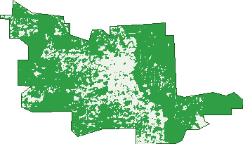
Green: 10 m cells where trees dominate, satellite 2021. Blue: water. The line is the suburb boundary.
| Canopy share, 1 m canopy height map, 2020 | 40.8% |
|---|---|
| Land with trees, 10 m satellite map, 2021 | 76.8% |
Demographics
Unemployment 4.6% · Labour-force participation 57.8%
Population by age in Kalamunda
| 0-4 | 283 |
|---|---|
| 5-14 | 877 |
| 15-19 | 380 |
| 20-24 | 337 |
| 25-34 | 500 |
| 35-44 | 779 |
| 45-54 | 991 |
| 55-64 | 982 |
| 65-74 | 1,025 |
| 75-84 | 737 |
| 85+ | 284 |
Dwelling types in Kalamunda
| House | 2,518 |
|---|---|
| Townhouse | 261 |
| Apartment | 36 |
| Other | 0 |
Households by weekly income in Kalamunda
| <$650 | 467 |
|---|---|
| $650-1,499 | 765 |
| $1,500-2,999 | 661 |
| $3,000+ | 692 |
Top ancestries in Kalamunda
| English | 3,636 |
|---|---|
| Australian | 2,311 |
| Scottish | 885 |
| Irish | 851 |
| Other | 559 |
| Italian | 482 |
Housing tenure in Kalamunda
| Owned | 1,385 |
|---|---|
| Mortgage | 957 |
| Rented | 420 |
| Other | 27 |
Cars per household in Kalamunda
| 0 | 99 |
|---|---|
| 1 | 850 |
| 2 | 1,103 |
| 3 | 432 |
| 4+ | 302 |
Commute to work in Kalamunda
| Car | 2,254 |
|---|---|
| Train | 14 |
| Bus | 69 |
| Tram/ferry | 0 |
| Walked | 54 |
| Bicycle | 7 |
| Home | 318 |
Top countries of birth in Kalamunda
| England | 1,049 |
|---|---|
| New Zealand | 185 |
| Scotland | 105 |
| South Africa | 97 |
| Italy | 75 |
| Ireland | 74 |
Languages used at home in Kalamunda
| Italian | 93 |
|---|---|
| German | 73 |
| Afrikaans | 27 |
| Mandarin | 17 |
| Thai | 17 |
| Japanese | 15 |
Birds & Wildlife Nearby
35,121 bird observations recorded near Kalamunda — most often seen:
- Twenty-eight Parrot (2,316)
- Red-capped Parrot (2,083)
- South-western Australian Magpie (2,065)
- Common Bronzewing (1,731)
- Western Brown Honeyeater (1,584)
- Galah (1,367)
- New Holland Honeyeater (1,343)
- Australian Ringneck (1,334)
- Western Australian Raven (1,281)
- Brown Honeyeater (1,251)
- Australian Raven (1,214)
- Western Galah (1,201)
- Australian Magpie (1,107)
Show all 30 birds recorded near Kalamunda
- Western Red Wattlebird (1,090)
- Silvereye (1,083)
- South-western Singing Honeyeater (1,064)
- Red Wattlebird (974)
- Western Silvereye (973)
- South-western Grey Fantail (946)
- Southern Laughing Kookaburra (927)
- South-western New Holland Honeyeater (925)
- Weebill (920)
- Red-tailed Black Cockatoo (872)
- Laughing Turtle-dove (862)
- Laughing Kookaburra (856)
- Rainbow Lorikeet (835)
- Western Striated Pardalote (766)
- Singing Honeyeater (731)
- Splendid Fairy-wren (711)
- South-western Spotted Scrubwren (709)
Sightings reported by observers, not a survey, so the counts show what people record rather than what lives here. Source: Atlas of Living Australia.
Nearby Suburbs
The closest suburbs to Kalamunda:
- Piesse Brook (2.4 km)
- Gooseberry Hill (2.5 km)
- Lesmurdie (2.8 km)
- Walliston (2.8 km)
- Maida Vale (3.9 km)
- Forrestfield (4.5 km)
- Bickley (4.7 km)
- Hacketts Gully (5.1 km)
Embed this suburb
Add this free Kalamunda stat card to your own site — just copy the code:
Preview:
Cite this page
Quoting these figures? Copy the credit line:
Keep an eye on Kalamunda
One email when this data meaningfully changes — new census figures, prices, rankings. No spam, unsubscribe anytime.
Streets
- Alpine Road (31)
- Andrew Street (36)
- Avonia Road (7)
- Barber Street (53)
- Barron Road (1)
- Beenup Place (5)
- Benbullen Road (16)
- Betti Road (23)
- Binya Court (7)
- Bird Road (10)
- Blamire Road (27)
- Boonooloo Court (24)
- Boonooloo Road (104)
- Boree Road (2)
- Brie Brie Crescent (26)
- Brine Road (21)
- Brooks Street (113)
- Broula Road (36)
- Burns Road (15)
- Burt Street (6)
- Byron Road (79)
- Cabarita Road (24)
- Canning Road (259)
- Carlisle Road (22)
- Carpene Place (6)
- Carramar Drive (14)
- Central Mall (43)
- Central Road (79)
- Chaucer Way (11)
- City Vista (11)
- Colac Place (2)
- Collins Road (23)
- Coral Road (51)
- Coreen Way (18)
- Cotherstone Road (68)
- Cousins Close (5)
- Crayden Road (28)
- Crescent Road (3)
- Crestview Crescent (26)
- Crocus Road (7)
- Curran Court (3)
- Dilkara Place (6)
- Dixon Road (38)
- Dorrington Road (3)
- East Terrace (16)
- Echo Road (6)
- Elizabeth Street (46)
- Enid Road (24)
- Francis Road (14)
- Gladstone Road (8)
- Gloucester Road (43)
- Grace Road (5)
- Gregona Place (8)
- Gunbar Way (19)
- Guppy Road (12)
- Harbour Road (7)
- Haynes Street (85)
- Headingly Road (29)
- Heath Road (135)
- Herald Close (7)
- Hillview Street (15)
- Hinkler Road (20)
- Holly Way E (8)
- Holly Way W (7)
- Hope Crescent (1)
- Hummerston Road (14)
- Jackson Road (4)
- James Road (19)
- Jones Street (11)
- Josephine Crescent (18)
- Kalamunda Road (137)
- Karralika Avenue (2)
- Karu Road (17)
- Keats Road (3)
- King Road (7)
- Kirkdale Road (12)
- Lalor Place (16)
- Lane Road (8)
- Lesmurdie Road E (7)
- Lewis Road (15)
- Lillie Street (1)
- Lindsay Street (15)
- Littley Rest (3)
- Longfellow Road (1)
- Lookout Road (22)
- Lyndhurst Road (62)
- Manooka Way (5)
- Marie Way (8)
- Mason Road (45)
- Mcness Road (35)
- Mcrae Road (16)
- Mead Street (50)
- Moran Road (3)
- Mount Terrace (8)
- Mounthaven Street (13)
- Mundaring Weir Road (82)
- Nangana Way (24)
- Nangkita Road (18)
- Nangkita Way (3)
- Orange Valley Road (123)
- Ozone Terrace (26)
- Panoramic Terrace (15)
- Parke Road (1)
- Patricia Road (21)
- Pauline Avenue (23)
- Peet Road (32)
- Persimmon Place (24)
- Petunia Street (19)
- Phillip Grove (28)
- Pipers Place (5)
- Poets Lane (35)
- Prospect Crescent (25)
- Railway Road (128)
- Recreation Road (70)
- Roach Road (5)
- Robert Road (15)
- Robins Road (29)
- Robusta Road (19)
- Sampson Close (7)
- Sampson Road (36)
- Schmitt Road (34)
- School Street (24)
- Seaview Terrace (37)
- Secrett Lane (16)
- Seymour Road (7)
- Shakespeare Road (16)
- Shelley Road (11)
- Simeon Close (15)
- Snowball Road (50)
- Spring Road (39)
- Springdale Road (12)
- St Emilies Road (2)
- Standen Court (5)
- Stanhope Road (30)
- Stirk Street (8)
- Sunset Crescent (19)
- Swindells Lane (15)
- Taylor Road (20)
- Temby Avenue (87)
- Tom Millar Close (4)
- Traylen Road (49)
- Urch Road (51)
- Valley Road (38)
- View Way (6)
- Walbeck Road (18)
- West Terrace (33)
- White Road (20)
- Wilkins Road (23)
- Williams Street (58)
- Windy Ridge Lane (11)
- Winsor Road (23)
- Yorna Road (26)