Wodonga VIC 3690
12,800 addresses · 484 streets
Indi Electorate › Wodonga LGA › Wodonga · 253 km from Melbourne
📦 Thinking of moving here? Read the Wodonga moving guide

Living Here
A regional city on the Victoria-NSW border twinned with Albury, Wodonga is a transport and service hub. Households average 2.3 people and the median age is 39. Median household income is $1,364 a week, and rent is affordable at around $280.
Wodonga is a suburb of Victoria, home to about 20,259 people, with a median age of 39. The typical household earns around $1,364 a week, with median rent near $280 a week. Most homes are houses. About 61% of households own their home and 38% rent. Most workers drive to work. Common community backgrounds include Australian, English, Irish. On the ABS socio-economic scale it sits in decile 3 of 10 nationally — a more disadvantaged area. The median house sells for about $540,000.
Over time — Census 2001 → 2021
Dashed line: district figures for the Wodonga statistical area (SA2), the smallest area the ABS published before 2011. Solid line: Wodonga itself.
Getting Around & Local Services
4 supermarkets
2 dentists
1 physiotherapist
1 optometrist
3 childcare & kindergartens
1 library
2 golf clubs
1 dog park
3 bakeries
3 hardware stores
2 hairdressers
1 beauty salon
Getting around. Train station: Wodonga, 3.2 km north-west · Bus interchange: Albury Station, 6.4 km north-east · Airport: Albury Airport, 9.7 km north-east.
Sport & Recreation
7 facilities recorded in Wodonga.
- Kelly Park Cricket, Croquet, Netball, Soccer, Tennis (Outdoor)
- Martin Park Australian Rules Football, Cricket, Netball
- Willow Park Cricket, Skating, Soccer
- Wodonga Athletics Complex Athletics
- Wodonga Bowling Club Lawn Bowls
- Wodonga Olympic Pool Swimming, Water Polo
- Wodonga Racecourse Recreation Reserve Australian Rules Football, Cricket, Equestrian
Socio-economic Standing
Deciles from 1 (lowest) to 10 (highest), against all Australian suburbs. The overall figure weighs advantage and disadvantage together; economic resources counts income and housing, and education & jobs counts qualifications and occupation. They often differ. Source: ABS SEIFA 2021.
Median Sale Prices
Median of recorded sales in the period, not a valuation. Source: Victorian Property Sales Report, Land Use Victoria.
Tree cover
🌳 Tree canopy: 10.3% share of land under canopy · satellite map, 2020
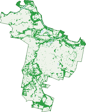
Green: 10 m cells where trees dominate, satellite 2021. Blue: water. The line is the suburb boundary.
| Canopy share, 1 m canopy height map, 2020 | 10.3% |
|---|---|
| Land with trees, 10 m satellite map, 2021 | 24.8% |
Demographics
Unemployment 5% · Labour-force participation 60.1%
Population by age in Wodonga
| 0-4 | 1,254 |
|---|---|
| 5-14 | 2,622 |
| 15-19 | 1,218 |
| 20-24 | 1,149 |
| 25-34 | 2,790 |
| 35-44 | 2,540 |
| 45-54 | 2,422 |
| 55-64 | 2,418 |
| 65-74 | 2,230 |
| 75-84 | 1,244 |
| 85+ | 367 |
Dwelling types in Wodonga
| House | 7,050 |
|---|---|
| Townhouse | 981 |
| Apartment | 104 |
| Other | 18 |
Households by weekly income in Wodonga
| <$650 | 1,506 |
|---|---|
| $650-1,499 | 2,697 |
| $1,500-2,999 | 2,440 |
| $3,000+ | 1,012 |
Top ancestries in Wodonga
| Australian | 8,052 |
|---|---|
| English | 7,847 |
| Irish | 2,399 |
| Scottish | 2,089 |
| Other | 1,636 |
| German | 1,387 |
Housing tenure in Wodonga
| Owned | 2,460 |
|---|---|
| Mortgage | 2,438 |
| Rented | 3,057 |
| Other | 59 |
Cars per household in Wodonga
| 0 | 504 |
|---|---|
| 1 | 3,058 |
| 2 | 3,075 |
| 3 | 952 |
| 4+ | 436 |
Commute to work in Wodonga
| Car | 7,088 |
|---|---|
| Train | 0 |
| Bus | 29 |
| Tram/ferry | 10 |
| Walked | 185 |
| Bicycle | 71 |
| Home | 766 |
Top countries of birth in Wodonga
| England | 365 |
|---|---|
| India | 304 |
| New Zealand | 180 |
| Germany | 158 |
| Philippines | 153 |
| Vietnam | 134 |
Languages used at home in Wodonga
| Nepali | 177 |
|---|---|
| Vietnamese | 150 |
| Punjabi | 122 |
| Hindi | 73 |
| Mandarin | 71 |
| German | 71 |
Birds & Wildlife Nearby
15,715 bird observations recorded near Wodonga — most often seen:
- Australian Magpie (900)
- Magpie-lark (799)
- Galah (796)
- Superb Fairy-wren (694)
- Red Wattlebird (693)
- Common Starling (663)
- Australian Wood Duck (660)
- Australian White Ibis (648)
- Pacific Black Duck (638)
- Australian Raven (614)
- Eurasian Blackbird (613)
- White-plumed Honeyeater (613)
- Crested Pigeon (569)
Show all 30 birds recorded near Wodonga
- Willie Wagtail (536)
- Welcome Swallow (526)
- Red-rumped Parrot (501)
- House Sparrow (489)
- Crimson Rosella (455)
- Pied Currawong (447)
- Dusky Moorhen (440)
- Spotted Turtle-dove (424)
- Masked Lapwing (394)
- Laughing Kookaburra (367)
- Grey Fantail (352)
- Sulphur-crested Cockatoo (348)
- Australasian Purple Swamphen (345)
- Red-browed Finch (314)
- Eurasian Coot (301)
- White-faced Heron (291)
- Silvereye (285)
Sightings reported by observers, not a survey, so the counts show what people record rather than what lives here. Source: Atlas of Living Australia.
Nearby Suburbs
The closest suburbs to Wodonga:
- West Wodonga (3.2 km)
- Bandiana (3.5 km)
- Leneva (3.7 km)
- Gateway Island (4.4 km)
- Huon Creek (4.5 km)
- Killara (5.5 km)
- Castle Creek (7.2 km)
- Baranduda (7.3 km)
Embed this suburb
Add this free Wodonga stat card to your own site — just copy the code:
Preview:
Cite this page
Quoting these figures? Copy the credit line:
Keep an eye on Wodonga
One email when this data meaningfully changes — new census figures, prices, rankings. No spam, unsubscribe anytime.
Streets
- Melrose Drive (61)
- Memorial Drive (46)
- Mena Court (5)
- Meridien Boulevard (19)
- Merlinda Court (11)
- Michael Drive (14)
- Middleton Crescent (19)
- Milan Court (8)
- Milend Street (12)
- Mill Street (9)
- Millar Court (1)
- Milos Boulevard (49)
- Mint Street (40)
- Mirabelle Court (12)
- Mitchell Street (143)
- Moloney Drive (40)
- Moonya Drive (27)
- Mores Court (15)
- Morrison Street (32)
- Mortlock Drive (15)
- Moulder Court (7)
- Muir Court (7)
- Mulqueeney Street (32)
- Murphy Street (33)
- Murray Street (10)
- Mylon Court (7)
- Nelson Court (19)
- Newland Street (8)
- Newman Crescent (17)
- Nicole Crescent (47)
- Nilmar Avenue (16)
- Noel Street (21)
- Norah Avenue (11)
- Nordsvan Drive (70)
- Norm Court (12)
- Odonoghue Street (7)
- Oleander Court (11)
- Olley Road (15)
- Omeara Street (56)
- Osburn Street (41)
- Oslo Court (7)
- Paris Court (4)
- Park Lane (31)
- Park View Close (35)
- Parkfield Drive (17)
- Parkland Drive (26)
- Parnaby Street (25)
- Partridge Way (16)
- Pearce Street (83)
- Peeler Street (24)
- Pembroke Crescent (14)
- Peregrine Place (22)
- Petcare Place (1)
- Peterkin Lane (5)
- Pettiford Court (6)
- Phefley Court (12)
- Phillips Street (65)
- Pickering Place (16)
- Pinkerton Court (14)
- Pollard Street (14)
- Pope Terrace (8)
- Poplar Street (18)
- Porta Court (11)
- Powell Court (7)
- Prague Avenue (15)
- Premier Close (19)
- Pressnell Lane (4)
- Pretty Street (9)
- Primrose Way (19)
- Proctor Street (17)
- Prunis Court (5)
- Pyke Court (5)
- Queen Street (35)
- Quinlivan Place (16)
- Quirk Court (24)
- Railway Street (42)
- Rattray Avenue (36)
- Reid Street (42)
- Rex Court (9)
- Richardson Street (19)
- Riga Court (12)
- Ripponlea Avenue (12)
- Riverview Terrace (30)
- Rogers Avenue (34)
- Romsey Court (16)
- Roseland Road (24)
- Rosemont Court (26)
- Ross Close (30)
- Royce Court (17)
- Rundle Street (36)
- Ruthven Circuit (34)
- Sadlier Street (25)
- Saldaise Street (6)
- Samantha Terrace (21)
- Sanctuary Boulevard (39)
- Sangsters Road (15)
- Sans Souci Drive (54)
- Sanyo Drive (48)
- Saunders Crescent (17)
- Scarborough Drive (20)
- Schlink Street (25)
- Schubert Crescent (35)
- Serin Lane (2)
- Sexton Place (9)
- Sheathers Road (6)
- Silky Oak Avenue (55)
- Singh Court (12)
- Skipton Court (31)
- Smythe Street (26)
- Snowdon Street (29)
- Sofia Court (6)
- South Street (149)
- Spring Avenue (7)
- Stanger Court (20)
- Stanley Street (101)
- Stapleton Court (25)
- Starbush Road (28)
- Steele Road (15)
- Stephen Court (7)
- Sticklewort Road (8)
- Sticklewort Street (7)
- Stiff Court (4)
- Stock Route (4)
- Stott Court (17)
- Strathmore Street (20)
- Streets Road (19)
- Sutton Court (12)
- Swan Street (27)
- Swansea Close (6)
- Tangney Circuit (13)
- Tanner Terrace (26)
- Tarakan Street (44)
- The Court (10)
- The Mews (7)
- Thomas Mitchell Drive (230)
- Thorneycroft Avenue (51)
- Throssell Crescent (17)
- Toledo Court (10)
- Tower Street (36)
- Tredegar Street (5)
- Trimble Lane (2)
- Trudewind Road (78)
- Turner Court (7)
- Twomey Court (11)
- Uralla Court (5)
- Valour Court (10)
- Vermont Street (61)
- Victoria Cross Parade (118)
- Vienna Court (6)
- Vining Court (10)
- Waratah Way (54)
- Wark Street (2)
- Warrina Court (8)
- Warsaw Crescent (27)
- Warwick Road (31)
- Watson Street (68)
- Wattle Court (12)
- Weathers Place (8)
- Webber Harris Court (16)
- Webber-harris Court (15)
- Wheeler Street (2)
- Whenby Court (8)
- Whernside Drive (35)
- Whytes Court (5)
- Wigelia Court (3)
- Wigg Street (94)
- Wilca Way (6)
- Wilkinson Drive (25)
- Willett Drive (15)
- William Street (143)
- Willow Parade (23)
- Willowdale Street (9)
- Wilson Street (154)
- Wiltshire Crescent (34)
- Windsor Street (12)
- Wirilda Close (37)
- Wise Court (9)
- Wodonga Street (14)
- Woodland Street (46)
- Woodrush Rise (4)
- Wornes Drive (48)
- Yarralumla Drive (33)
- Zeinert Street (27)
- Ziebell Circuit (18)