West Wodonga VIC 3690
7,721 addresses · 364 streets
Indi Electorate › Wodonga LGA › West Wodonga · 252 km from Melbourne
📦 Thinking of moving here? Read the West Wodonga moving guide

Living Here
West Wodonga is a suburb of Victoria, home to about 14,794 people, with a median age of 39. The typical household earns around $1,452 a week, with median rent near $290 a week. Most homes are houses. About 65% of households own their home and 34% rent. Most workers drive to work. Common community backgrounds include Australian, English, Irish. On the ABS socio-economic scale it sits in decile 2 of 10 nationally — a more disadvantaged area. The median house sells for about $549,500.
Over time — Census 2001 → 2021
Dashed line: district figures for the West Wodonga statistical area (SA2), the smallest area the ABS published before 2011. Solid line: West Wodonga itself.
Getting Around & Local Services
15 schools
2 pharmacies
4 doctors & medical clinics
2 dentists
1 physiotherapist
1 optometrist
5 childcare & kindergartens
1 library
2 golf clubs
1 bakery
2 butchers
3 hardware stores
1 beauty salon
Getting around. Train station: Wodonga, 2.7 km north-east · Bus interchange: Albury Station, 7.9 km north-east · Airport: Albury Airport, 11.5 km north-east.
Sport & Recreation
9 facilities recorded in West Wodonga.
- Birallee Park Australian Rules Football, BMX, Cricket, Hockey, Netball
- Cookinburra Circuit Cycling
- Fireshed Circuit Cycling
- Flemings Circuit Cycling
- Gayview Park Baseball, Softball
- La Trobe University Soccer Facility Soccer
- Parklands Tennis Facility Netball, Tennis (Outdoor)
- Wodonga Golf Club Golf
- Wodonga Sports & Leisure Centre (YMCA) Basketball, Fitness / Gymnasium Workouts, Netball (Indoor), Swimming, Volleyball
Socio-economic Standing
Deciles from 1 (lowest) to 10 (highest), against all Australian suburbs. The overall figure weighs advantage and disadvantage together; economic resources counts income and housing, and education & jobs counts qualifications and occupation. They often differ. Source: ABS SEIFA 2021.
Median Sale Prices
Median of recorded sales in the period, not a valuation. Source: Victorian Property Sales Report, Land Use Victoria.
Tree cover
🌳 Tree canopy: 14.5% share of land under canopy · satellite map, 2020
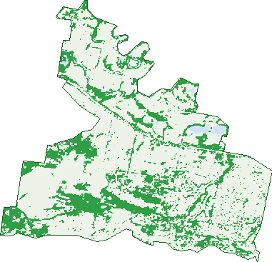
Green: 10 m cells where trees dominate, satellite 2021. Blue: water. The line is the suburb boundary.
| Canopy share, 1 m canopy height map, 2020 | 14.5% |
|---|---|
| Land with trees, 10 m satellite map, 2021 | 25.2% |
Demographics
Unemployment 4.3% · Labour-force participation 60.5%
Population by age in West Wodonga
| 0-4 | 825 |
|---|---|
| 5-14 | 2,018 |
| 15-19 | 996 |
| 20-24 | 870 |
| 25-34 | 1,831 |
| 35-44 | 1,758 |
| 45-54 | 1,895 |
| 55-64 | 1,878 |
| 65-74 | 1,638 |
| 75-84 | 781 |
| 85+ | 298 |
Dwelling types in West Wodonga
| House | 5,021 |
|---|---|
| Townhouse | 454 |
| Apartment | 179 |
| Other | 29 |
Households by weekly income in West Wodonga
| <$650 | 1,009 |
|---|---|
| $650-1,499 | 1,765 |
| $1,500-2,999 | 1,831 |
| $3,000+ | 751 |
Top ancestries in West Wodonga
| Australian | 6,302 |
|---|---|
| English | 6,010 |
| Irish | 1,660 |
| Scottish | 1,508 |
| German | 1,059 |
| Ancestry NS | 889 |
Housing tenure in West Wodonga
| Owned | 1,635 |
|---|---|
| Mortgage | 1,952 |
| Rented | 1,848 |
| Other | 61 |
Cars per household in West Wodonga
| 0 | 236 |
|---|---|
| 1 | 1,948 |
| 2 | 2,210 |
| 3 | 699 |
| 4+ | 400 |
Commute to work in West Wodonga
| Car | 5,321 |
|---|---|
| Train | 0 |
| Bus | 22 |
| Tram/ferry | 11 |
| Walked | 71 |
| Bicycle | 45 |
| Home | 584 |
Top countries of birth in West Wodonga
| England | 281 |
|---|---|
| New Zealand | 149 |
| Philippines | 117 |
| Germany | 93 |
| India | 74 |
| Vietnam | 51 |
Languages used at home in West Wodonga
| Punjabi | 53 |
|---|---|
| Vietnamese | 53 |
| Tagalog | 52 |
| Mandarin | 49 |
| Croatian | 41 |
| Filipino | 38 |
Birds & Wildlife Nearby
13,308 bird observations recorded near West Wodonga — most often seen:
- Australian Magpie (707)
- Galah (681)
- Magpie-lark (665)
- Eurasian Blackbird (595)
- Red Wattlebird (577)
- Australian White Ibis (571)
- Pacific Black Duck (566)
- Superb Fairy-wren (553)
- Australian Wood Duck (530)
- Common Starling (520)
- White-plumed Honeyeater (501)
- Australian Raven (498)
- Crested Pigeon (475)
Show all 30 birds recorded near West Wodonga
- House Sparrow (437)
- Willie Wagtail (419)
- Red-rumped Parrot (417)
- Dusky Moorhen (406)
- Welcome Swallow (399)
- Pied Currawong (385)
- Spotted Turtle-dove (370)
- Crimson Rosella (359)
- Masked Lapwing (354)
- Australasian Purple Swamphen (313)
- Sulphur-crested Cockatoo (308)
- Grey Fantail (306)
- Eurasian Coot (301)
- Silvereye (293)
- Red-browed Finch (276)
- White-faced Heron (265)
- Laughing Kookaburra (261)
Sightings reported by observers, not a survey, so the counts show what people record rather than what lives here. Source: Atlas of Living Australia.
Nearby Suburbs
The closest suburbs to West Wodonga:
- Wodonga (3.2 km)
- Huon Creek (3.7 km)
- Gateway Island (5.5 km)
- Leneva (5.8 km)
- Castle Creek (6.7 km)
- Bandiana (6.7 km)
- Killara (8.8 km)
- Baranduda (10.3 km)
Embed this suburb
Add this free West Wodonga stat card to your own site — just copy the code:
Preview:
Cite this page
Quoting these figures? Copy the credit line:
Keep an eye on West Wodonga
One email when this data meaningfully changes — new census figures, prices, rankings. No spam, unsubscribe anytime.
Streets
- Aberdeen Drive (39)
- Ace Court (4)
- Adams Court (5)
- Airey Court (8)
- Allan Place (3)
- Ambrose Crescent (34)
- Angus Avenue (30)
- Argyle Way (27)
- Armstrong Terrace (5)
- Ashburton Circuit (20)
- Auhl Court (7)
- Avoca Court (8)
- Azure Drive (75)
- Bakes Mews (9)
- Ballara Drive (35)
- Ballyneal Terrace (8)
- Bambrick Court (4)
- Barton Street (99)
- Bedford Street (1)
- Bel-air Street (13)
- Bent Place (19)
- Beresford Court (26)
- Beryl Court (3)
- Bidstrup Road (6)
- Billy Hughes Court (32)
- Birallee Place (58)
- Birchman Court (18)
- Birdie Street (43)
- Birkdale Terrace (28)
- Bisque Court (13)
- Blackwood Avenue (13)
- Blair Court (4)
- Bolte Court (5)
- Borthwick Court (12)
- Bowen Place (8)
- Bower Place (6)
- Bowman Court (14)
- Bowser Court (13)
- Brassie Street (9)
- Brewer Drive (92)
- Bruce Street (39)
- Brunswick Court (7)
- Buckland Court (42)
- Burns Court (20)
- Caddy Court (5)
- Cain Court (4)
- Calder Close (4)
- Calder Lane (3)
- Campaspe Street (70)
- Campbell Avenue (49)
- Canary Court (9)
- Carnoustie Avenue (20)
- Celtic Court (14)
- Chandler Street (33)
- Chauncey Court (7)
- Chifley Street (45)
- Cleeland Court (12)
- Clifford Court (11)
- Clubhouse Place (2)
- Clyde Court (6)
- Colombo Court (16)
- Concord Street (13)
- Condamine Street (23)
- Conlan Circuit (32)
- Connell Court (11)
- Cook Place (36)
- Coopers Road (22)
- Cottlesloe Court (20)
- Coventry Court (23)
- Coyles Road (39)
- Cromer Fairway (8)
- Curtin Court (7)
- Cyrilla Court (22)
- Daintree Way (55)
- Dalton Avenue (48)
- Danson Road (3)
- Darling Street (13)
- David Place (10)
- Deakin Court (17)
- Delatite Court (19)
- Derwent Way (27)
- Diamond Drive (22)
- Dibley Mews (7)
- Discovery Way (3)
- Donelan Court (11)
- Donelly Avenue (30)
- Dover Court (11)
- Down Court (5)
- Drage Road (31)
- Draw Court (16)
- Drewett Road (7)
- Driver Place (4)
- Drummond Court (11)
- Dundee Drive (54)
- Eagle Court (12)
- Eagleton Place (12)
- Edinburgh Circuit (44)
- Edwards Road (2)
- Eleanore Court (13)
- Elkington Road (10)
- Ellison Court (12)
- Elmslie Circuit (27)
- Elmslie Close (4)
- Emerald Avenue (73)
- Emery Court (44)
- Fadden Court (22)
- Fade Court (11)
- Falcon Circuit (51)
- Felltimber Creek Road (41)
- Firestone Way (73)
- Fireweed Crescent (19)
- Fisher Court (17)
- Fitzroy Street (19)
- Flag Place (12)
- Fleet Street (17)
- Fletcher Court (30)
- Flinders Way (218)
- Footmark Court (7)
- Forde Court (26)
- Fortescue Street (18)
- Francis Court (10)
- Fraser Court (15)
- Fussel Court (13)
- Fyfe Court (7)
- Ganton Way (4)
- Garden Cove (21)
- Garnet Circuit (26)
- Gascoyne Lane (8)
- Gayview Drive (68)
- Geehi Court (5)
- Georgina Street (16)
- Gillies Court (3)
- Gillman Terrace (11)
- Glades Lane (2)
- Glenapp Court (7)
- Golflinks Avenue (68)
- Goulburn Court (7)
- Goynes Road (1)
- Grace Court (14)
- Greenhill Road (3)
- Greygown Street (1)
- Hales Court (11)
- Hamer Mews (8)
- Hamilton Place (25)
- Hanlon Court (49)
- Hastings Way (21)
- Hawk Place (16)
- Hedgerow Court (3)
- Heron Court (13)
- Hibbett Crescent (13)
- Higginson Court (11)
- Highland Crescent (36)
- Hogan Court (21)
- Holloway Mews (4)
- Holt Place (15)
- Hook Court (16)
- Hopkins Crescent (13)
- Horsfall Court (19)
- Howqua Circuit (25)
- Hunter Street (12)
- Hylton Court (6)
- Indigo Close (10)
- Ingrams Road (12)
- Innisbrook Avenue (33)
- Innisfree Drive (35)
- Inverness Street (11)
- Iron Close (4)
- Iron Way (67)
- Irvine Court (14)
- Isdell Place (19)
- Jackson Drive (23)
- Jade Court (23)
- Jakary Court (8)
- Jamieson Court (16)
- Jardine Street (9)
- Jason Circuit (16)
- Jasper Close (17)
- Jennifer Place (8)
- Juno Lane (4)
- Kelle Court (6)
- Keogh Street (4)
- Kerferd Court (15)
- Kilkenny Street (11)
- Killarney Court (8)
- Kingfisher Drive (78)
- Kingsbury Court (31)
- Kingswood Way (8)
- Kirner Court (4)
- Koetong Crescent (39)
- Kookaburra Place (5)
- Koschel Mews (4)
- Kyle Court (53)
- Lachlan Court (20)
- Lambourn Drive (35)
- Lanark Court (5)
- Lark Court (10)
- Latrobe Court (8)
- Lawrence Street (178)
- Lawson Street (41)
- Ledbury Circuit (51)
- Leopard Court (16)
- Leopard Way (5)
- Lewington Street (9)
- Links Street (7)
- Lloyd Street (27)
- Loddon Court (5)
- Lomond Court (22)
- Lucas Court (4)
- Lynch Court (23)
- Lyons Place (11)
- Lytham Court (13)
- Macleay Court (6)
- Macpherson Street (8)
- Macquarie Road (12)
- Madden Place (3)
- Mahoney Road (9)
- Maitland Crescent (16)
- Maitland Street (1)
- Marshall Street (166)
- Mashie Way (41)
- Mayfair Drive (161)
- Mccrohan Court (17)
- Mcculloch Crescent (27)
- Mcculloch Lane (2)
- Mceachern Court (25)
- Mcewen Crescent (58)
- Mcewen Lane (2)
- Mcgaffin Court (17)
- Mcgaffins Road (47)
- Mcgregor Court (15)
- Mcintyre Court (12)
- Mckoy Street (66)
- Mclean Crescent (21)
- Mcleish Court (12)
- Mcmahon Place (54)
- Medinah Court (5)
- Melbourne Road (20)
- Melrose Drive (85)
- Menzies Street (59)
- Merion Court (7)
- Midway Court (1)
- Millar Court (13)
- Montclair Avenue (30)
- Moorefield Park Drive (25)
- Murray Way (52)
- Namoi Place (2)
- National Court (11)
- Nedlands Close (18)
- Niblick Street (27)
- Nicholson Court (9)
- Nightingale Avenue (99)
- North Park Drive (41)
- Oakmont Circuit (26)
- Oatlands Fairway (14)
- Odonnell Court (9)
- Old Barnawartha Road (6)
- Onyx Court (4)
- Opal Court (20)
- Oshanassy Court (17)
- Osprey Circuit (18)
- Otago Way (13)
- Ovens Court (10)
- Pacific Court (13)
- Page Court (30)
- Par Court (8)
- Paramount Court (21)
- Park Hall Village Place (89)
- Parkers Road (1)
- Peacock Avenue (47)
- Pearl Place (9)
- Pin Court (4)
- Pinehurst Fairway (15)
- Pitcher Place (5)
- Pitmedden Drive (31)
- Player Court (11)
- Plenty Court (5)
- Plenty Way (5)
- Plunketts Road (7)
- Pooley Court (19)
- Prendergast Street (35)
- Prestwick Place (11)
- Probyns Road (5)
- Prosper Court (26)
- Putter Place (4)
- Quail Court (11)
- Rapsey Court (18)
- Raven Court (24)
- Reeve Court (4)
- Ritter Road (34)
- Riversdale Place (14)
- Roadshow Drive (61)
- Robert Crescent (30)
- Romet Road (28)
- Ronan Court (13)
- Roper Street (17)
- Rosanna Court (10)
- Rosella Mews (10)
- Rubicon Street (14)
- Ruby Road (25)
- Sapphire Circuit (32)