Leneva VIC 3691
1,410 addresses · 109 streets
Indi Electorate › Wodonga LGA › Leneva · 251 km from Melbourne
📦 Thinking of moving here? Read the Leneva moving guide

Living Here
Leneva is a suburb of Victoria, home to about 1,317 people, with a median age of 33. The typical household earns around $2,305 a week, with median rent near $390 a week. Most homes are houses. About 84% of households own their home and 16% rent. Most workers drive to work. Common community backgrounds include Australian, English, Irish. On the ABS socio-economic scale it sits in decile 9 of 10 nationally — a relatively advantaged area. The median house sells for about $675,000.
Over time — Census 2001 → 2021
Dashed line: district figures for the Wodonga statistical area (SA2), the smallest area the ABS published before 2011. Solid line: Leneva itself.
Getting Around & Local Services
13 schools
- Grace Christian College Wodonga
- Kerribana Primary School
- Wodonga South Primary School
- Bandiana Primary School (Closed 2025)
- Wodonga Middle Years College Huon Campus
- Wodonga Primary School
- Wodonga Senior Secondary College
- St Monica's Primary School
- St Francis of Assisi Primary School
- Wodonga Flexible Learning Centre
3 cafés & restaurants
1 supermarket
2 Catholic churches
1 medical clinic
2 dentists
1 physiotherapist
1 optometrist
1 childcare centre
1 library
1 golf club
1 butcher
3 hardware stores
Getting around. Train station: Wodonga, 6.8 km north · Bus interchange: Albury Station, 9.5 km north · Airport: Albury Airport, 12.4 km north-east.
Socio-economic Standing
Deciles from 1 (lowest) to 10 (highest), against all Australian suburbs. The overall figure weighs advantage and disadvantage together; economic resources counts income and housing, and education & jobs counts qualifications and occupation. They often differ. Source: ABS SEIFA 2021.
Median Sale Prices
Median of recorded sales in the period, not a valuation. Source: Victorian Property Sales Report, Land Use Victoria.
Tree cover
🌳 Tree canopy: 23.1% share of land under canopy · satellite map, 2020
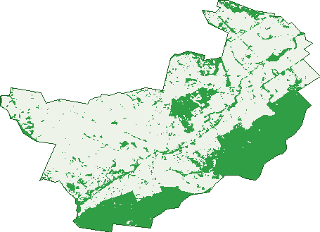
Green: 10 m cells where trees dominate, satellite 2021. Blue: water. The line is the suburb boundary.
| Canopy share, 1 m canopy height map, 2020 | 23.1% |
|---|---|
| Land with trees, 10 m satellite map, 2021 | 30.9% |
Demographics
Unemployment 1.6% · Labour-force participation 76.3%
Population by age in Leneva
| 0-4 | 114 |
|---|---|
| 5-14 | 226 |
| 15-19 | 76 |
| 20-24 | 63 |
| 25-34 | 210 |
| 35-44 | 231 |
| 45-54 | 166 |
| 55-64 | 98 |
| 65-74 | 78 |
| 75-84 | 33 |
| 85+ | 11 |
Dwelling types in Leneva
| House | 428 |
|---|---|
| Townhouse | 0 |
| Apartment | 0 |
| Other | 0 |
Households by weekly income in Leneva
| <$650 | 25 |
|---|---|
| $650-1,499 | 79 |
| $1,500-2,999 | 188 |
| $3,000+ | 112 |
Top ancestries in Leneva
| Australian | 587 |
|---|---|
| English | 543 |
| Irish | 169 |
| Scottish | 144 |
| German | 95 |
| Other | 85 |
Housing tenure in Leneva
| Owned | 105 |
|---|---|
| Mortgage | 254 |
| Rented | 70 |
| Other | 0 |
Cars per household in Leneva
| 0 | 3 |
|---|---|
| 1 | 87 |
| 2 | 213 |
| 3 | 77 |
| 4+ | 43 |
Commute to work in Leneva
| Car | 568 |
|---|---|
| Train | 0 |
| Bus | 3 |
| Tram/ferry | 0 |
| Walked | 9 |
| Bicycle | 3 |
| Home | 81 |
Top countries of birth in Leneva
| England | 21 |
|---|---|
| New Zealand | 18 |
| Philippines | 14 |
| South Africa | 12 |
| United States | 6 |
| Germany | 5 |
Languages used at home in Leneva
| Malayalam | 4 |
|---|---|
| Tagalog | 4 |
| Turkish | 4 |
| Afrikaans | 3 |
| Arabic | 3 |
| French | 3 |
Birds & Wildlife Nearby
6,904 bird observations recorded near Leneva — most often seen:
- Australian Magpie (445)
- Galah (435)
- Superb Fairy-wren (370)
- Red Wattlebird (362)
- Magpie-lark (320)
- Crimson Rosella (303)
- Common Starling (301)
- Eurasian Blackbird (287)
- Australian Raven (270)
- Grey Fantail (248)
- Pied Currawong (247)
- Laughing Kookaburra (224)
- Spotted Turtle-dove (215)
Show all 30 birds recorded near Leneva
- Crested Pigeon (211)
- Silvereye (207)
- Australian White Ibis (204)
- White-plumed Honeyeater (199)
- House Sparrow (198)
- Australian Wood Duck (183)
- Red-browed Finch (169)
- Welcome Swallow (167)
- Willie Wagtail (167)
- Eastern Rosella (162)
- Yellow-rumped Thornbill (161)
- Pacific Black Duck (158)
- New Holland Honeyeater (146)
- Spotted Pardalote (141)
- Blue-faced Honeyeater (135)
- Noisy Miner (135)
- Black-faced Cuckoo-shrike (134)
Sightings reported by observers, not a survey, so the counts show what people record rather than what lives here. Source: Atlas of Living Australia.
Nearby Suburbs
The closest suburbs to Leneva:
- Wodonga (3.7 km)
- Bandiana (4 km)
- Huon Creek (4.1 km)
- Baranduda (4.9 km)
- Castle Creek (5.4 km)
- Killara (5.8 km)
- West Wodonga (5.8 km)
- Gateway Island (7.8 km)
Embed this suburb
Add this free Leneva stat card to your own site — just copy the code:
Preview:
Cite this page
Quoting these figures? Copy the credit line:
Keep an eye on Leneva
One email when this data meaningfully changes — new census figures, prices, rankings. No spam, unsubscribe anytime.
Streets
- Ashley Close (4)
- Balcombe Avenue (8)
- Bantik Track (1)
- Barber Road (1)
- Bears Hill Drive (3)
- Beaumont Street (13)
- Beechworth-wodonga Road (62)
- Birchall Crescent (19)
- Both Street (14)
- Bowyer-smith Way (4)
- Boyes Road (11)
- Bramwell Avenue (28)
- Bremer Avenue (80)
- Brewers Road (2)
- Britten Drive (8)
- Burgess Lane (2)
- Burnham Road (17)
- Byshby Street (16)
- Canon Street (26)
- Castle Creek Road (4)
- Cattanach Way (3)
- Cavendish Street (12)
- Chatham Road (23)
- Craig Circuit (43)
- Cranesbill Lane (3)
- Cromwell Road (18)
- Cullen Street (2)
- Darmodys Road (2)
- Davidson Road (9)
- Dempster Place (27)
- Dianella Court (13)
- Drapers Road (6)
- Dwyer Avenue (39)
- Easton Lane (7)
- Edgar Road (11)
- Edmunds Place (12)
- Edneys Road (4)
- Ennis Road (6)
- Ewarts Road (3)
- Fairfax Close (8)
- Farnworth Way (10)
- Faye Street (3)
- Ferndale Road (13)
- Fietz Street (8)
- Firmstone Road (23)
- Fivefields Road (17)
- Forsyth Road (22)
- Frederic Road (8)
- Frederic Street Road (3)
- Frichot Avenue (4)
- Gibbons Street (1)
- Gibbons Way (3)
- Greschke Street (5)
- Hampshire Boulevard (31)
- Heilmann Place (10)
- Highcliffe Road (14)
- Hillcrest Street (10)
- Ivers Place (8)
- Jennings Boulevard (21)
- Jubilee Road (10)
- Juckert Road (13)
- Junckert Road (2)
- Kinchington Road (12)
- Kite Place (11)
- Liddell Street (9)
- Lockhead Street (2)
- Lomandra Court (11)
- Lovett Way (5)
- Marsden Road (6)
- Martins Road (4)
- Mather Street (11)
- Matrush Street (20)
- Mcswiney Court (27)
- Mortimer Terrace (45)
- Mynard Road (8)
- Newbound Street (17)
- Pardolate Avenue (6)
- Pem Cove (6)
- Pertzel Drive (8)
- Phillips Road (1)
- Pierson Avenue (18)
- Pinedale Street (1)
- Pound Lane (1)
- Pound Road (15)
- Queensberry Road (15)
- Raymond Street (9)
- Ridley Avenue (19)
- Rix Mews (6)
- Rothauser Way (9)
- Salisbury Road (9)
- Salisbury Street (6)
- Saru Road (2)
- Schiebs Street (10)
- Seymour Lane (14)
- Sharman Road (12)
- Sheridan Street (3)
- Singleton Road (12)
- Southgate Drive (24)
- Stobie Crescent (21)
- Streets Road (85)
- Swanick Street (17)
- Todd Circuit (5)
- Torrens Road (15)
- Unaipon Street (28)
- Vale Road (8)
- Waverley Circle (6)
- Waverley Close (6)
- Waverley Road (8)
- Willis Road (4)