Thornbury VIC 3071
11,661 addresses · 89 streets
Cooper Electorate › Darebin LGA › Thornbury · 7 km from Melbourne
📦 Thinking of moving here? Read the Thornbury moving guide

Living Here
A sought-after inner-northern Melbourne suburb known for its High Street cafes, Thornbury is established and increasingly affluent. Households average 2.3 people and the median age is 37. Median household income is $1,971 a week, with rent around $391.
Thornbury is a suburb of Victoria, home to about 19,005 people, with a median age of 37. The typical household earns around $1,971 a week, with median rent near $391 a week. Most homes are houses. About 57% of households own their home and 42% rent. Most workers work from home. Common community backgrounds include English, Australian, Irish. On the ABS socio-economic scale it sits in decile 10 of 10 nationally — a relatively advantaged area. The median house sells for about $1,430,000.
Over time — Census 2001 → 2021
Dashed line: district figures for the Thornbury statistical area (SA2), the smallest area the ABS published before 2011. Solid line: Thornbury itself.
Getting Around & Local Services
72 hospitals
2 playgrounds
2 electricians
Getting around. Train station: Thornbury, 600 m north-west · Tram stop: Stop 39: Gooch Street, 350 m west · Bus interchange: Northland Shopping Centre, 2.9 km north-east · Ferry wharf: Berth 5, 7.4 km south-west · Airport: Essendon Fields Airport, 9.9 km west.
Sport & Recreation
8 facilities recorded in Thornbury.
- Athletique Health Club Preston Aerobics, Fitness / Gymnasium Workouts
- Hayes Park Cricket, Soccer
- John Cain Memorial Park Lawn Bowls, Soccer
- Mayer Park Cricket, Soccer
- Northcote Golf Course Golf
- Northcote Indoor Sports Beach Volleyball, Cricket (Indoor), Netball (Indoor), Soccer (Indoor Soccer / Futsal)
- Sir Doug Nicholls Reserve Australian Rules Football, Netball
- Thornbury Bowls Club Lawn Bowls
Socio-economic Standing
Deciles from 1 (lowest) to 10 (highest), against all Australian suburbs. The overall figure weighs advantage and disadvantage together; economic resources counts income and housing, and education & jobs counts qualifications and occupation. They often differ. Source: ABS SEIFA 2021.
Median Sale Prices
Median of recorded sales in the period, not a valuation. Source: Victorian Property Sales Report, Land Use Victoria.
Tree cover
🌳 Tree canopy: 6.7% share of land under canopy · satellite map, 2020
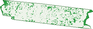
Green: 10 m cells where trees dominate, satellite 2021. Blue: water. The line is the suburb boundary.
| Canopy share, 1 m canopy height map, 2020 | 6.7% |
|---|---|
| Land with trees, 10 m satellite map, 2021 | 10.6% |
Demographics
Unemployment 4.6% · Labour-force participation 71.2%
Population by age in Thornbury
| 0-4 | 976 |
|---|---|
| 5-14 | 1,828 |
| 15-19 | 825 |
| 20-24 | 1,030 |
| 25-34 | 3,851 |
| 35-44 | 3,370 |
| 45-54 | 2,685 |
| 55-64 | 1,856 |
| 65-74 | 1,233 |
| 75-84 | 852 |
| 85+ | 495 |
Dwelling types in Thornbury
| House | 4,111 |
|---|---|
| Townhouse | 1,872 |
| Apartment | 1,957 |
| Other | 52 |
Households by weekly income in Thornbury
| <$650 | 1,197 |
|---|---|
| $650-1,499 | 1,758 |
| $1,500-2,999 | 2,302 |
| $3,000+ | 2,349 |
Top ancestries in Thornbury
| English | 5,648 |
|---|---|
| Australian | 4,714 |
| Irish | 2,729 |
| Italian | 2,400 |
| Other | 2,330 |
| Greek | 2,063 |
Housing tenure in Thornbury
| Owned | 2,165 |
|---|---|
| Mortgage | 2,306 |
| Rented | 3,347 |
| Other | 91 |
Cars per household in Thornbury
| 0 | 1,148 |
|---|---|
| 1 | 3,771 |
| 2 | 2,283 |
| 3 | 506 |
| 4+ | 207 |
Commute to work in Thornbury
| Car | 3,473 |
|---|---|
| Train | 208 |
| Bus | 65 |
| Tram/ferry | 236 |
| Walked | 214 |
| Bicycle | 374 |
| Home | 4,623 |
Top countries of birth in Thornbury
| Greece | 795 |
|---|---|
| England | 549 |
| Italy | 548 |
| New Zealand | 412 |
| India | 223 |
| Vietnam | 183 |
Languages used at home in Thornbury
| Greek | 1,520 |
|---|---|
| Italian | 800 |
| Arabic | 330 |
| Vietnamese | 216 |
| Mandarin | 200 |
| Spanish | 169 |
Birds & Wildlife Nearby
261,184 bird observations recorded near Thornbury — most often seen:
- Rainbow Lorikeet (17,721)
- Common Myna (17,713)
- Noisy Miner (14,682)
- Red Wattlebird (13,640)
- Little Raven (13,505)
- Magpie-lark (13,161)
- Australian Magpie (11,855)
- Spotted Turtle-dove (11,579)
- Rock Dove (11,215)
- Pacific Black Duck (10,050)
- Dusky Moorhen (9,829)
- Eurasian Blackbird (9,317)
- Silver Gull (7,862)
Show all 30 birds recorded near Thornbury
- Common Starling (7,745)
- Pied Currawong (7,526)
- Grey Butcherbird (7,319)
- Welcome Swallow (6,943)
- Australian Wood Duck (6,440)
- Willie Wagtail (6,238)
- Crested Pigeon (5,834)
- White-plumed Honeyeater (5,816)
- Brown Thornbill (5,766)
- Red-rumped Parrot (5,745)
- Chestnut Teal (5,449)
- Australian White Ibis (5,171)
- Superb Fairy-wren (5,166)
- White-browed Scrubwren (5,000)
- Southern Victoria Australian Magpie (4,760)
- Eurasian Coot (4,101)
- Grey Fantail (4,036)
Sightings reported by observers, not a survey, so the counts show what people record rather than what lives here. Source: Atlas of Living Australia.
Nearby Suburbs
The closest suburbs to Thornbury:
- Northcote (1.7 km)
- Preston (1.8 km)
- Fairfield (2.4 km)
- Brunswick East (2.9 km)
- Bellfield (3.1 km)
- Alphington (3.3 km)
- Fitzroy North (3.4 km)
- Ivanhoe (3.5 km)
Embed this suburb
Add this free Thornbury stat card to your own site — just copy the code:
Preview:
Cite this page
Quoting these figures? Copy the credit line:
Keep an eye on Thornbury
One email when this data meaningfully changes — new census figures, prices, rankings. No spam, unsubscribe anytime.
Streets
- Agg Street (89)
- Agnes Street (24)
- Alexandra Street (39)
- Alston Court (23)
- Alston Street (85)
- Anderson Road (58)
- Archbold Street (18)
- Armadale Street (49)
- Aviary Grove (28)
- Ballantyne Street (287)
- Benjamin Street (16)
- Blythe Street (19)
- Boyd Street (19)
- Bradley Avenue (56)
- Clapham Street (129)
- Clarendon Street (444)
- Clyde Street (271)
- Collins Street (533)
- Comas Grove (69)
- Darebin Road (216)
- Dundas Street (465)
- Ethel Street (71)
- Fenwick Street (47)
- Flinders Street (382)
- Ford Crescent (22)
- Francis Grove (51)
- Fyffe Street (211)
- Gillies Street (47)
- Gladhall Avenue (26)
- Gooch Street (453)
- Grange Road (15)
- Hammond Street (122)
- Harold Street (292)
- Harry Street (45)
- High Street (625)
- Hill Street (21)
- Hobson Street (12)
- Hutton Street (324)
- Ibis Place (15)
- Inman Street (3)
- Johnson Street (19)
- Jones Street (43)
- Kelvin Grove (31)
- Kemp Street (206)
- Keon Street (192)
- Leinster Grove (34)
- Lewis Street (61)
- Mansfield Street (560)
- Martin Street (243)
- Matisi Street (52)
- Mcclure Street (26)
- Miller Street (127)
- Monash Avenue (17)
- Murray Street (84)
- Newcastle Street (28)
- Newman Street (88)
- Normanby Avenue (408)
- Pender Street (355)
- Plow Street (31)
- Railway Place (1)
- Raleigh Street (351)
- Rathmines Street (99)
- Rayment Street (11)
- Rennie Street (169)
- Riley Street (15)
- Rosella Walk (6)
- Rossmoyne Street (450)
- Shaftesbury Parade (219)
- Sheppard Street (5)
- Smith Street (384)
- Sparks Avenue (40)
- Speight Street (170)
- Spencer Street (13)
- St David Street (97)
- St Georges Road (189)
- Station Street (218)
- Stott Street (13)
- Strettle Street (146)
- Swift Street (74)
- Taylor Street (19)
- Tharratt Street (17)
- Theobald Street (32)
- Turner Street (3)
- Victoria Road (130)
- Wales Street (48)
- Walsh Avenue (38)
- Watt Street (25)
- Wilmoth Street (52)
- Woolton Avenue (301)