Bellfield VIC 3081
1,273 addresses · 35 streets
Jagajaga Electorate › Banyule LGA › Bellfield · 10 km from Melbourne
📦 Thinking of moving here? Read the Bellfield moving guide

Living Here
Bellfield is a suburb of Victoria, home to about 1,996 people, with a median age of 36. The typical household earns around $1,845 a week, with median rent near $375 a week. Most homes are houses. About 53% of households own their home and 44% rent. Most workers drive to work. Common community backgrounds include English, Australian, Irish. On the ABS socio-economic scale it sits in decile 6 of 10 nationally — a mid-range area. The median house sells for about $951,000.
Over time — Census 2011 → 2021
Getting Around & Local Services
67 schools
- Waratah Special Development School
- St Pius X Catholic Primary School
- St Bernadette's School
- Thornbury High School
- Charles La Trobe P-12 College Olympic Village Primary Campus
- Victorian School of Languages
- Ivanhoe Primary School
- The Austin School
- Ivanhoe Girls' Grammar School
- Northern College of the Arts and Technology
17 childcare & kindergartens
1 dog park
1 carpenter
Getting around. Train station: Eaglemont, 1.8 km south-east · Tram stop: Stop 49: Murray Road, 2.9 km north-west · Bus interchange: Northland Shopping Centre, 1.7 km north-west · Airport: Essendon Fields Airport, 12.7 km west.
Sport & Recreation
1 facility recorded in Bellfield.
- Ford Park Australian Rules Football, Cricket
Socio-economic Standing
Deciles from 1 (lowest) to 10 (highest), against all Australian suburbs. The overall figure weighs advantage and disadvantage together; economic resources counts income and housing, and education & jobs counts qualifications and occupation. They often differ. Source: ABS SEIFA 2021.
Median Sale Prices
Median of recorded sales in the period, not a valuation. Source: Victorian Property Sales Report, Land Use Victoria.
Tree cover
🌳 Tree canopy: 6.8% share of land under canopy · satellite map, 2020
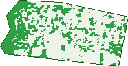
Green: 10 m cells where trees dominate, satellite 2021. Blue: water. The line is the suburb boundary.
| Canopy share, 1 m canopy height map, 2020 | 6.8% |
|---|---|
| Land with trees, 10 m satellite map, 2021 | 30.3% |
Demographics
Unemployment 6.9% · Labour-force participation 61.9%
Population by age in Bellfield
| 0-4 | 132 |
|---|---|
| 5-14 | 207 |
| 15-19 | 104 |
| 20-24 | 122 |
| 25-34 | 386 |
| 35-44 | 331 |
| 45-54 | 229 |
| 55-64 | 222 |
| 65-74 | 168 |
| 75-84 | 69 |
| 85+ | 36 |
Dwelling types in Bellfield
| House | 542 |
|---|---|
| Townhouse | 177 |
| Apartment | 7 |
| Other | 0 |
Households by weekly income in Bellfield
| <$650 | 134 |
|---|---|
| $650-1,499 | 152 |
| $1,500-2,999 | 228 |
| $3,000+ | 175 |
Top ancestries in Bellfield
| English | 513 |
|---|---|
| Australian | 461 |
| Other | 360 |
| Irish | 198 |
| Chinese | 160 |
| Scottish | 144 |
Housing tenure in Bellfield
| Owned | 155 |
|---|---|
| Mortgage | 225 |
| Rented | 315 |
| Other | 16 |
Cars per household in Bellfield
| 0 | 69 |
|---|---|
| 1 | 271 |
| 2 | 276 |
| 3 | 71 |
| 4+ | 18 |
Commute to work in Bellfield
| Car | 461 |
|---|---|
| Train | 12 |
| Bus | 21 |
| Tram/ferry | 0 |
| Walked | 13 |
| Bicycle | 12 |
| Home | 259 |
Top countries of birth in Bellfield
| China | 65 |
|---|---|
| India | 46 |
| Lebanon | 45 |
| Philippines | 39 |
| Vietnam | 36 |
| Sri Lanka | 32 |
Languages used at home in Bellfield
| Arabic | 106 |
|---|---|
| Greek | 78 |
| Mandarin | 67 |
| Vietnamese | 53 |
| Cantonese | 47 |
| Tamil | 43 |
Birds & Wildlife Nearby
371,182 bird observations recorded near Bellfield — most often seen:
- Rainbow Lorikeet (22,408)
- Noisy Miner (21,938)
- Little Raven (19,245)
- Common Myna (17,563)
- Pacific Black Duck (16,279)
- Magpie-lark (16,125)
- Red Wattlebird (15,752)
- Dusky Moorhen (15,092)
- Australian Magpie (15,049)
- Sulphur-crested Cockatoo (13,682)
- Grey Butcherbird (13,011)
- Eurasian Coot (12,097)
- Welcome Swallow (12,082)
Show all 30 birds recorded near Bellfield
- Australian Wood Duck (11,953)
- Spotted Turtle-dove (11,787)
- Australasian Purple Swamphen (11,343)
- Pied Currawong (10,546)
- Superb Fairy-wren (10,506)
- Galah (10,264)
- Eurasian Blackbird (10,225)
- Chestnut Teal (10,199)
- Brown Thornbill (9,054)
- Southern Victoria Australian Magpie (8,931)
- Grey Fantail (8,602)
- Silver Gull (8,532)
- Laughing Kookaburra (8,427)
- Red-rumped Parrot (7,864)
- Common Starling (7,799)
- Australasian Grebe (7,504)
- Rock Dove (7,323)
Sightings reported by observers, not a survey, so the counts show what people record rather than what lives here. Source: Atlas of Living Australia.
Nearby Suburbs
The closest suburbs to Bellfield:
- Ivanhoe (1.4 km)
- Heidelberg West (1.5 km)
- Heidelberg Heights (1.6 km)
- Eaglemont (2.2 km)
- Heidelberg (2.4 km)
- Ivanhoe East (2.8 km)
- Rosanna (3 km)
- Fairfield (3.1 km)
Embed this suburb
Add this free Bellfield stat card to your own site — just copy the code:
Preview:
Cite this page
Quoting these figures? Copy the credit line:
Keep an eye on Bellfield
One email when this data meaningfully changes — new census figures, prices, rankings. No spam, unsubscribe anytime.
Streets
- Ashe Crescent (37)
- Banksia Street (7)
- Bell Street (86)
- Boronia Court (20)
- Carlyle Crescent (18)
- Daphne Crescent (139)
- Davidson Street (45)
- Erica Court (11)
- Garrett Crescent (25)
- Griffiths Street (74)
- Harrison Street (15)
- Iris Street (2)
- Ivy Street (4)
- Liberty Parade (76)
- Lime Court (18)
- Mcgrath Street (13)
- Mcneil Street (30)
- Okeefe Street (51)
- Orange Court (12)
- Oriel Road (52)
- Pearse Street (6)
- Perkins Avenue (38)
- Plunkett Street (49)
- Poplar Crescent (59)
- Prunus Court (9)
- Rich Crescent (57)
- Skeffington Street (47)
- Sullivan Street (28)
- Toohey Court (23)
- Toohey Street (21)
- Waterdale Road (41)
- Webb Court (8)
- Wilkinson Crescent (65)
- Willow Court (13)
- Wimpole Crescent (74)