Brunswick East VIC 3057
9,988 addresses · 107 streets
Wills Electorate › Moreland LGA › Brunswick East · 5 km from Melbourne
📦 Thinking of moving here? Read the Brunswick East moving guide

Living Here
A sought-after inner-northern Melbourne suburb known for its cafes and Lygon Street strip, Brunswick East is youthful and apartment-rich. Households average 2.0 people and the median age is 33. Median household income is $2,088 a week, with rent around $421.
Brunswick East is a suburb of Victoria, home to about 13,279 people, with a median age of 33. The typical household earns around $2,088 a week, with median rent near $421 a week. Most homes are apartments. About 45% of households own their home and 54% rent. Most workers work from home. Common community backgrounds include English, Australian, Irish. On the ABS socio-economic scale it sits in decile 10 of 10 nationally — a relatively advantaged area. The median house sells for about $1,353,000.
Over time — Census 2001 → 2021
Dashed line: district figures for the Brunswick East statistical area (SA2), the smallest area the ABS published before 2011. Solid line: Brunswick East itself.
Getting Around & Local Services
31 childcare & kindergartens
2 playgrounds
Getting around. Train station: Brunswick, 1.5 km west · Tram stop: Stop 123: Albert Street, 350 m west · Bus interchange: Southern Cross Coach Terminal, 5.4 km south · Ferry wharf: Berth 5, 5.4 km south · Airport: Essendon Fields Airport, 8.4 km north-west.
Sport & Recreation
5 facilities recorded in Brunswick East.
- Allard Park Australian Rules Football, Cricket
- Balfe Park Soccer
- Brunswick Bowls Club Lawn Bowls
- Brunswick Velodrome Cycling
- Fleming Park Australian Rules Football, Cricket, Lacrosse
Socio-economic Standing
Deciles from 1 (lowest) to 10 (highest), against all Australian suburbs. The overall figure weighs advantage and disadvantage together; economic resources counts income and housing, and education & jobs counts qualifications and occupation. They often differ. Source: ABS SEIFA 2021.
Median Sale Prices
Median of recorded sales in the period, not a valuation. Source: Victorian Property Sales Report, Land Use Victoria.
Tree cover
🌳 Tree canopy: 7.7% share of land under canopy · satellite map, 2020
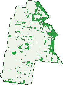
Green: 10 m cells where trees dominate, satellite 2021. Blue: water. The line is the suburb boundary.
| Canopy share, 1 m canopy height map, 2020 | 7.7% |
|---|---|
| Land with trees, 10 m satellite map, 2021 | 13.0% |
Demographics
Unemployment 4.3% · Labour-force participation 77.8%
Population by age in Brunswick East
| 0-4 | 489 |
|---|---|
| 5-14 | 762 |
| 15-19 | 364 |
| 20-24 | 1,069 |
| 25-34 | 4,450 |
| 35-44 | 2,659 |
| 45-54 | 1,405 |
| 55-64 | 933 |
| 65-74 | 597 |
| 75-84 | 372 |
| 85+ | 173 |
Dwelling types in Brunswick East
| House | 1,439 |
|---|---|
| Townhouse | 1,640 |
| Apartment | 3,230 |
| Other | 41 |
Households by weekly income in Brunswick East
| <$650 | 661 |
|---|---|
| $650-1,499 | 1,301 |
| $1,500-2,999 | 2,275 |
| $3,000+ | 1,839 |
Top ancestries in Brunswick East
| English | 4,195 |
|---|---|
| Australian | 3,175 |
| Other | 2,098 |
| Irish | 1,980 |
| Italian | 1,565 |
| Scottish | 1,536 |
Housing tenure in Brunswick East
| Owned | 1,147 |
|---|---|
| Mortgage | 1,691 |
| Rented | 3,399 |
| Other | 71 |
Cars per household in Brunswick East
| 0 | 1,191 |
|---|---|
| 1 | 3,642 |
| 2 | 1,139 |
| 3 | 246 |
| 4+ | 90 |
Commute to work in Brunswick East
| Car | 1,990 |
|---|---|
| Train | 28 |
| Bus | 37 |
| Tram/ferry | 561 |
| Walked | 260 |
| Bicycle | 500 |
| Home | 4,193 |
Top countries of birth in Brunswick East
| England | 513 |
|---|---|
| New Zealand | 393 |
| Italy | 367 |
| United States | 182 |
| Greece | 174 |
| Malaysia | 138 |
Languages used at home in Brunswick East
| Italian | 583 |
|---|---|
| Greek | 370 |
| Spanish | 243 |
| Mandarin | 212 |
| Arabic | 201 |
| Cantonese | 121 |
Birds & Wildlife Nearby
419,344 bird observations recorded near Brunswick East — most often seen:
- Common Myna (27,626)
- Rainbow Lorikeet (26,277)
- Red Wattlebird (21,580)
- Magpie-lark (21,257)
- Noisy Miner (21,097)
- Rock Dove (21,041)
- Little Raven (20,705)
- Spotted Turtle-dove (17,766)
- Australian Magpie (17,333)
- Silver Gull (16,777)
- Eurasian Blackbird (15,900)
- Pacific Black Duck (14,725)
- Dusky Moorhen (14,374)
Show all 30 birds recorded near Brunswick East
- Common Starling (13,897)
- Welcome Swallow (12,365)
- White-plumed Honeyeater (11,888)
- Willie Wagtail (10,382)
- Pied Currawong (10,345)
- House Sparrow (10,288)
- Crested Pigeon (10,249)
- Superb Fairy-wren (10,122)
- Grey Butcherbird (9,960)
- Chestnut Teal (9,405)
- Australian White Ibis (8,835)
- Red-rumped Parrot (7,668)
- New Holland Honeyeater (7,666)
- Eurasian Coot (7,606)
- Bell Miner (7,562)
- Australian Wood Duck (7,443)
- Galah (7,205)
Sightings reported by observers, not a survey, so the counts show what people record rather than what lives here. Source: Atlas of Living Australia.
Nearby Suburbs
The closest suburbs to Brunswick East:
- Brunswick (1.3 km)
- Princes Hill (1.5 km)
- Fitzroy North (1.6 km)
- Carlton North (1.7 km)
- Northcote (2.2 km)
- Parkville (2.8 km)
- Clifton Hill (2.9 km)
- Thornbury (2.9 km)
Embed this suburb
Add this free Brunswick East stat card to your own site — just copy the code:
Preview:
Cite this page
Quoting these figures? Copy the credit line:
Keep an eye on Brunswick East
One email when this data meaningfully changes — new census figures, prices, rankings. No spam, unsubscribe anytime.
Streets
- Aintree Street (27)
- Akeroa Avenue (10)
- Albert Street (265)
- Albion Street (85)
- Alister Street (1)
- Alsace Street (36)
- Amess Street (14)
- Arnold Street (56)
- Balmoral Avenue (71)
- Barkly Street (582)
- Bellvue Street (1)
- Bill Barry Close (2)
- Bladen Avenue (19)
- Bluestone Way (149)
- Blyth Street (247)
- Brunswick Road (343)
- Canning Street (13)
- Clara Street (26)
- Clarence Street (83)
- Clarke Street (33)
- Cocoa Jackson Lane (2)
- Cross Street (8)
- Cunnington Avenue (11)
- Deakin Street (36)
- Dianella Walkway (21)
- Donald Street (82)
- Duke Street (17)
- Eddy Street (4)
- Edward Street (614)
- Edwina Way (4)
- Elesbury Avenue (39)
- Elm Grove (10)
- Elsie Mews (24)
- Ethel Street (34)
- Evans Street (1)
- French Avenue (38)
- Fulton Court (8)
- Galada Way (14)
- Gale Street (25)
- Gamble Street (53)
- Gear Street (44)
- Glenlyon Road (204)
- Glenmorgan Street (80)
- Hamer Street (19)
- Harrison Street (106)
- Hickford Street (121)
- Holmes Street (187)
- Hutchinson Street (102)
- Inverness Street (38)
- Ivory Way (27)
- Jarvie Street (40)
- Jenkin Street (20)
- John Street (311)
- King Street (23)
- Kingfisher Gardens (52)
- Kirkdale Street (19)
- Lanark Street (20)
- Lee Street (5)
- Leinster Grove (11)
- Leyden Street (23)
- Lincoln Street (35)
- Linden Street (54)
- Little Miller Street (95)
- Lomandra Walkway (20)
- Lord Street (17)
- Lowan Street (38)
- Lygon Street (2,210)
- Lyndhurst Crescent (52)
- Maghull Street (31)
- Mary Moodie Way (20)
- Methven Street (23)
- Miller Street (79)
- Mitchell Street (122)
- Moreland Road (26)
- Myrtle Street (13)
- Nicholson Street (866)
- Noel Street (7)
- Nunan Street (59)
- Oconnor Street (57)
- Orari Avenue (10)
- Overend Street (2)
- Pareora Avenue (7)
- Park Street (28)
- Parkview Avenue (12)
- Peers Street (18)
- Piera Street (46)
- Primrose Street (10)
- Queen Street (31)
- Rathdowne Street (15)
- Rickard Street (7)
- Roberts Street (43)
- Rupert Street (39)
- Ryan Street (63)
- Sedgman Street (20)
- St Phillip Street (72)
- Station Street (13)
- Stewart Street (254)
- Sumner Street (18)
- Taranaki Avenue (9)
- Temuka Avenue (11)
- Timaru Avenue (9)
- Truscott Street (11)
- Victoria Street (349)
- Village Avenue (240)
- Waihi Avenue (7)
- Weigall Street (15)
- Weston Street (245)