Sunshine North VIC 3020
7,802 addresses · 205 streets
Fraser Electorate › Brimbank LGA › Sunshine North · 12 km from Melbourne
📦 Thinking of moving here? Read the Sunshine North moving guide

Living Here
Sunshine North is a suburb of Victoria, home to about 12,047 people, with a median age of 37. The typical household earns around $1,399 a week, with median rent near $341 a week. Most homes are houses. About 68% of households own their home and 30% rent. Most workers drive to work. Common community backgrounds include Vietnamese, Chinese, Ancestry NS. On the ABS socio-economic scale it sits in decile 2 of 10 nationally — a more disadvantaged area. The median house sells for about $750,000.
Over time — Census 2001 → 2021
Dashed line: district figures for the Sunshine North statistical area (SA2), the smallest area the ABS published before 2011. Solid line: Sunshine North itself.
Getting Around & Local Services
19 Catholic churches
2 physiotherapists
18 childcare & kindergartens
Getting around. Train station: Albion, 1.7 km south-west · Tram stop: Stop 49: Central Park Avenue, 3.7 km east · Bus interchange: Sunshine Station, 2.5 km south · Airport: Essendon Fields Airport, 7.1 km north-east.
Sport & Recreation
4 facilities recorded in Sunshine North.
- Dempster Park Australian Rules Football, Basketball, Cricket, Tennis (Outdoor)
- Duke Street Reserve Basketball, Fitness / Gymnasium Workouts
- Loyd Reserve Cricket, Soccer
- Sunshine Roller Skating Centre Roller Sports - Other
Socio-economic Standing
Deciles from 1 (lowest) to 10 (highest), against all Australian suburbs. The overall figure weighs advantage and disadvantage together; economic resources counts income and housing, and education & jobs counts qualifications and occupation. They often differ. Source: ABS SEIFA 2021.
Median Sale Prices
Median of recorded sales in the period, not a valuation. Source: Victorian Property Sales Report, Land Use Victoria.
Tree cover
🌳 Tree canopy: 2.9% share of land under canopy · satellite map, 2020
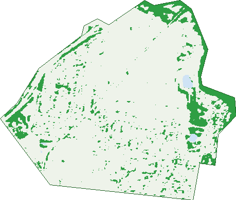
Green: 10 m cells where trees dominate, satellite 2021. Blue: water. The line is the suburb boundary.
| Canopy share, 1 m canopy height map, 2020 | 2.9% |
|---|---|
| Land with trees, 10 m satellite map, 2021 | 10.7% |
Demographics
Unemployment 8.4% · Labour-force participation 53.9%
Population by age in Sunshine North
| 0-4 | 695 |
|---|---|
| 5-14 | 1,309 |
| 15-19 | 662 |
| 20-24 | 867 |
| 25-34 | 2,046 |
| 35-44 | 1,548 |
| 45-54 | 1,501 |
| 55-64 | 1,441 |
| 65-74 | 1,026 |
| 75-84 | 614 |
| 85+ | 338 |
Dwelling types in Sunshine North
| House | 3,176 |
|---|---|
| Townhouse | 497 |
| Apartment | 163 |
| Other | 16 |
Households by weekly income in Sunshine North
| <$650 | 785 |
|---|---|
| $650-1,499 | 1,153 |
| $1,500-2,999 | 1,101 |
| $3,000+ | 560 |
Top ancestries in Sunshine North
| Vietnamese | 4,111 |
|---|---|
| Other | 1,856 |
| Chinese | 1,456 |
| Ancestry NS | 1,217 |
| Australian | 1,204 |
| English | 1,057 |
Housing tenure in Sunshine North
| Owned | 1,452 |
|---|---|
| Mortgage | 1,104 |
| Rented | 1,139 |
| Other | 76 |
Cars per household in Sunshine North
| 0 | 334 |
|---|---|
| 1 | 1,346 |
| 2 | 1,310 |
| 3 | 516 |
| 4+ | 256 |
Commute to work in Sunshine North
| Car | 3,171 |
|---|---|
| Train | 107 |
| Bus | 60 |
| Tram/ferry | 0 |
| Walked | 60 |
| Bicycle | 18 |
| Home | 786 |
Top countries of birth in Sunshine North
| Vietnam | 3,341 |
|---|---|
| Malta | 418 |
| India | 330 |
| Philippines | 226 |
| Myanmar | 213 |
| Italy | 193 |
Languages used at home in Sunshine North
| Vietnamese | 4,696 |
|---|---|
| Cantonese | 481 |
| Italian | 229 |
| Mandarin | 158 |
| Arabic | 152 |
| Spanish | 148 |
Birds & Wildlife Nearby
72,762 bird observations recorded near Sunshine North — most often seen:
- Little Raven (3,787)
- Red Wattlebird (3,433)
- Rainbow Lorikeet (3,378)
- Eurasian Blackbird (3,349)
- Australian Magpie (3,161)
- Common Myna (3,117)
- White-plumed Honeyeater (3,044)
- Pacific Black Duck (3,010)
- Common Starling (2,972)
- Superb Fairy-wren (2,946)
- House Sparrow (2,933)
- Dusky Moorhen (2,931)
- Magpie-lark (2,907)
Show all 30 birds recorded near Sunshine North
- New Holland Honeyeater (2,683)
- Welcome Swallow (2,595)
- Spotted Turtle-dove (2,562)
- Willie Wagtail (2,531)
- Rock Dove (2,257)
- Noisy Miner (2,214)
- Crested Pigeon (1,972)
- Eurasian Coot (1,742)
- Red-rumped Parrot (1,678)
- Red-browed Finch (1,634)
- Little Pied Cormorant (1,583)
- Chestnut Teal (1,553)
- White-faced Heron (1,514)
- Sulphur-crested Cockatoo (1,484)
- Australian Wood Duck (1,402)
- White-browed Scrubwren (1,222)
- Silvereye (1,168)
Sightings reported by observers, not a survey, so the counts show what people record rather than what lives here. Source: Atlas of Living Australia.
Nearby Suburbs
The closest suburbs to Sunshine North:
- Albion (2.2 km)
- Avondale Heights (2.3 km)
- Sunshine (2.5 km)
- Braybrook (2.8 km)
- Ardeer (3.3 km)
- Kealba (3.6 km)
- St Albans (3.7 km)
- Keilor East (3.7 km)
Embed this suburb
Add this free Sunshine North stat card to your own site — just copy the code:
Preview:
Cite this page
Quoting these figures? Copy the credit line:
Keep an eye on Sunshine North
One email when this data meaningfully changes — new census figures, prices, rankings. No spam, unsubscribe anytime.
Streets
- Albert Street (25)
- Alford Street (2)
- Alluvium Drive (4)
- Alvina Street (25)
- Annastasia Way (10)
- Arvona Avenue (19)
- Auburn Avenue (46)
- Augusta Crescent (38)
- Ayton Street (17)
- Balcombe Street (36)
- Baldwin Avenue (31)
- Balfour Avenue (78)
- Ball Street (19)
- Ballarat Road (70)
- Bangerang Avenue (59)
- Barwon Avenue (25)
- Baynton Avenue (59)
- Beale Place (5)
- Beardmore Lane (9)
- Bedser Street (19)
- Belmore Road (51)
- Ben Thanh Place (14)
- Berkshire Road (159)
- Berry Street (17)
- Blackmore Street (35)
- Bluebell Court (20)
- Boisdale Avenue (27)
- Bradley Street (24)
- Bradman Street (19)
- Braim Street (26)
- Brooker Court (8)
- Brushbox Street (23)
- Brushtail Court (14)
- Bryan Court (13)
- Brygee Close (26)
- Buckley Avenue (38)
- Bunnett Street (62)
- Burwood Avenue (29)
- Busch Street (37)
- Camperdown Avenue (100)
- Cary Street (51)
- Charles Street (27)
- Clayton Street (49)
- Comley Street (31)
- Compton Parade (55)
- Cooke Avenue (36)
- Coronation Street (22)
- Craddock Court (17)
- Cranbourne Avenue (79)
- Cromer Avenue (88)
- Cumberland Street (112)
- Cutts Street (35)
- Davies Avenue (104)
- Dendy Street (25)
- Dewdrop Court (3)
- Dinron Close (18)
- Dorman Close (2)
- Douglas Street (6)
- Downing Street (22)
- Doyle Street (9)
- Drake Street (10)
- Duke Street (204)
- Dunkeld Avenue (62)
- Eastcote Street (30)
- Edna Street (26)
- Elder Court (5)
- Elwood Avenue (62)
- Essex Street (52)
- Euroa Avenue (47)
- Evodia Street (11)
- Fawcett Street (35)
- Fawkner Street (14)
- Ferndale Road (72)
- Ford Avenue (92)
- Fulton Retreat (21)
- Furlong Road (98)
- Garnet Street (85)
- Gee Street (5)
- Gerald Street (28)
- Gilmour Road (3)
- Godfrey Avenue (43)
- Grainger Street (31)
- Greenstone Place (18)
- Gresford Street (20)
- Halong Drive (32)
- Hammond Street (23)
- Harley Street (24)
- Harvester Avenue (31)
- Hassett Street (17)
- Hawthorn Avenue (18)
- Henderson Street (18)
- Henley Gardens (27)
- Heron Avenue (35)
- Hoad Street (23)
- Holehouse Street (34)
- Imperial Avenue (79)
- Inglis Street (14)
- Isla Street (32)
- Jacana Court (13)
- Jeff Court (4)
- Johnson Street (29)
- Julie Court (6)
- Kingsmead Close (37)
- Knight Avenue (87)
- Lancaster Street (17)
- Lance Road (8)
- Laura Court (11)
- Laurie Avenue (12)
- Lincoln Street (54)
- Loch Entrance (5)
- Lodden Street (71)
- Lorikeet Court (14)
- Lurg Avenue (36)
- Maida Avenue (91)
- Maldon Court (15)
- Mansfield Avenue (49)
- Marshall Street (17)
- Mccoll Street (6)
- Mcgrath Place (14)
- Mcintyre Road (249)
- Mcleod Street (20)
- Meadowbank Drive (83)
- Melton Avenue (12)
- Metherall Street (93)
- Middlesex Street (16)
- Midway Lane (1)
- Mill Court (7)
- Mills Street (26)
- Mineral Terrace (63)
- Munro Avenue (81)
- Nettlefold Avenue (8)
- Northumberland Road (154)
- Nottingham Street (54)
- Orloff Court (14)
- Oxford Street (13)
- Paperbark Walk (21)
- Park Drive (24)
- Pebblestone Street (23)
- Penna Avenue (71)
- Perennial Drive (57)
- Phoenix Street (149)
- Plymouth Close (56)
- Prince Street (9)
- Ralston Avenue (22)
- Rankin Avenue (69)
- Redgum Drive (14)
- Ribbonwood Crescent (39)
- Rice Flower Road (54)
- Riverbend Way (43)
- Rivervalley Boulevard (74)
- Riverview Link (1)
- Robson Street (14)
- Romsey Avenue (51)
- Rosewall Street (43)
- Rothray Avenue (11)
- Roussac Court (24)
- Rufford Street (9)
- Ruth Street (26)
- Ryan Court (13)
- Salisbury Street (14)
- Sandford Avenue (94)
- Shadowbox Court (19)
- Shipley Court (13)
- Simpson Street (33)
- Sofia Court (8)
- Somers Street (11)
- Somerset Drive (98)
- Spalding Avenue (71)
- Spotted Gum Crescent (39)
- Sproul Street (19)
- St Albans Road (14)
- St Andrews Drive (44)
- Steers Street (3)
- Suffolk Road (193)
- Sunnybank Rise (7)
- Surman Court (21)
- Sussex Street (19)
- Talbot Street (26)
- Tania Street (28)
- Taniyha Place (30)
- Telford Court (14)
- Tennant Street (12)
- Theresa Street (15)
- Trickey Court (11)
- Troon Crescent (34)
- Tube Street (11)
- Tudor Road (45)
- Turnberry Road (2)
- Tyres Court (15)
- Urana Avenue (13)
- Vermont Avenue (52)
- Vickers Way (14)
- Victor Street (29)
- Walsh Street (17)
- Warwick Road (124)
- Wattlebird Court (124)
- West Avenue (9)
- Westmoreland Road (138)
- Whitehill Avenue (38)
- Willey Street (13)
- Willowbark Boulevard (12)
- Wiltshire Street (61)
- Winged Foot Drive (74)
- Woodland Circuit (25)
- Woodswallow Entrance (79)