Avondale Heights VIC 3034
5,812 addresses · 166 streets
Maribyrnong Electorate › Moonee Valley LGA › Avondale Heights · 11 km from Melbourne
📦 Thinking of moving here? Read the Avondale Heights moving guide

Living Here
Avondale Heights is a suburb of Victoria, home to about 12,388 people, with a median age of 45. The typical household earns around $1,587 a week, with median rent near $400 a week. Most homes are houses. About 77% of households own their home and 20% rent. Most workers drive to work. Common community backgrounds include Italian, Australian, English. On the ABS socio-economic scale it sits in decile 7 of 10 nationally — a mid-range area. The median house sells for about $980,500.
Over time — Census 2001 → 2021
Dashed line: district figures for the Keilor East statistical area (SA2), the smallest area the ABS published before 2011. Solid line: Avondale Heights itself.
Getting Around & Local Services
15 childcare & kindergartens
- Avondale Heights Early Years Centre
- Avondale Heights Kindergarten
- Rhonda Davis Kindergarten
- Avondale Heights Early Learning Centre
- Lincolnville Kindergarten
- Milleara Gardens Kindergarten & Playgroup
- Maribyrnong River Children's Centre
- North Maidstone Kindergarten
- Cherry Crescent Preschool
- Phoenix Street Childrens Centre
See all 15 childcare & kindergartens near Avondale Heights →
3 beauty salons
Getting around. Train station: Albion, 3.8 km south-west · Tram stop: Stop 49: Central Park Avenue, 1.6 km south-east · Bus interchange: Highpoint Shopping Centre, 2.6 km south-east · Airport: Essendon Fields Airport, 5.2 km north-east.
Sport & Recreation
2 facilities recorded in Avondale Heights.
- Canning Reserve Australian Rules Football, Cricket
- Doyle Reserve (Avondale Heights Reserve) Cricket, Soccer, Tennis (Outdoor)
Socio-economic Standing
Deciles from 1 (lowest) to 10 (highest), against all Australian suburbs. The overall figure weighs advantage and disadvantage together; economic resources counts income and housing, and education & jobs counts qualifications and occupation. They often differ. Source: ABS SEIFA 2021.
Median Sale Prices
Median of recorded sales in the period, not a valuation. Source: Victorian Property Sales Report, Land Use Victoria.
Tree cover
🌳 Tree canopy: 11% share of land under canopy · satellite map, 2020
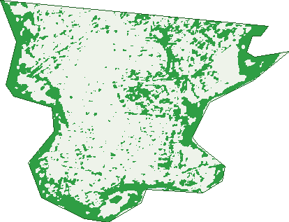
Green: 10 m cells where trees dominate, satellite 2021. Blue: water. The line is the suburb boundary.
| Canopy share, 1 m canopy height map, 2020 | 11.0% |
|---|---|
| Land with trees, 10 m satellite map, 2021 | 27.4% |
Demographics
Unemployment 5.4% · Labour-force participation 54.5%
Population by age in Avondale Heights
| 0-4 | 633 |
|---|---|
| 5-14 | 1,346 |
| 15-19 | 575 |
| 20-24 | 597 |
| 25-34 | 1,376 |
| 35-44 | 1,659 |
| 45-54 | 1,510 |
| 55-64 | 1,373 |
| 65-74 | 1,424 |
| 75-84 | 1,280 |
| 85+ | 607 |
Dwelling types in Avondale Heights
| House | 3,449 |
|---|---|
| Townhouse | 996 |
| Apartment | 21 |
| Other | 16 |
Households by weekly income in Avondale Heights
| <$650 | 830 |
|---|---|
| $650-1,499 | 1,216 |
| $1,500-2,999 | 1,139 |
| $3,000+ | 1,049 |
Top ancestries in Avondale Heights
| Italian | 2,958 |
|---|---|
| Australian | 1,947 |
| Other | 1,882 |
| English | 1,728 |
| Chinese | 942 |
| Vietnamese | 904 |
Housing tenure in Avondale Heights
| Owned | 2,115 |
|---|---|
| Mortgage | 1,291 |
| Rented | 887 |
| Other | 120 |
Cars per household in Avondale Heights
| 0 | 298 |
|---|---|
| 1 | 1,580 |
| 2 | 1,743 |
| 3 | 524 |
| 4+ | 274 |
Commute to work in Avondale Heights
| Car | 2,929 |
|---|---|
| Train | 53 |
| Bus | 31 |
| Tram/ferry | 12 |
| Walked | 51 |
| Bicycle | 18 |
| Home | 1,456 |
Top countries of birth in Avondale Heights
| Italy | 1,072 |
|---|---|
| Vietnam | 711 |
| Greece | 288 |
| India | 203 |
| China | 201 |
| Croatia | 189 |
Languages used at home in Avondale Heights
| Italian | 1,393 |
|---|---|
| Vietnamese | 839 |
| Greek | 579 |
| Cantonese | 405 |
| Croatian | 313 |
| Arabic | 288 |
Birds & Wildlife Nearby
110,876 bird observations recorded near Avondale Heights — most often seen:
- Rainbow Lorikeet (5,292)
- Little Raven (5,248)
- Australian Magpie (4,981)
- Magpie-lark (4,788)
- Pacific Black Duck (4,675)
- Red Wattlebird (4,669)
- Common Myna (4,535)
- Dusky Moorhen (4,507)
- Common Starling (4,457)
- Noisy Miner (4,283)
- Welcome Swallow (4,272)
- Eurasian Blackbird (4,213)
- Spotted Turtle-dove (4,172)
Show all 30 birds recorded near Avondale Heights
- White-plumed Honeyeater (4,112)
- Rock Dove (3,870)
- Superb Fairy-wren (3,860)
- House Sparrow (3,639)
- Willie Wagtail (3,568)
- New Holland Honeyeater (3,364)
- Eurasian Coot (3,135)
- Crested Pigeon (3,056)
- Chestnut Teal (3,044)
- Little Pied Cormorant (2,859)
- Silver Gull (2,708)
- Red-rumped Parrot (2,580)
- White-faced Heron (2,565)
- Australian Wood Duck (2,321)
- Little Black Cormorant (2,102)
- Sulphur-crested Cockatoo (2,013)
- Australasian Purple Swamphen (1,988)
Sightings reported by observers, not a survey, so the counts show what people record rather than what lives here. Source: Atlas of Living Australia.
Nearby Suburbs
The closest suburbs to Avondale Heights:
- Sunshine North (2.3 km)
- Keilor East (2.3 km)
- Essendon West (2.4 km)
- Maidstone (2.7 km)
- Braybrook (2.8 km)
- Maribyrnong (2.9 km)
- Aberfeldie (3.1 km)
- Niddrie (3.2 km)
Embed this suburb
Add this free Avondale Heights stat card to your own site — just copy the code:
Preview:
Cite this page
Quoting these figures? Copy the credit line:
Keep an eye on Avondale Heights
One email when this data meaningfully changes — new census figures, prices, rankings. No spam, unsubscribe anytime.
Streets
- Ahern Place (2)
- Aldea Crescent (19)
- Alexander Street (71)
- Amis Crescent (25)
- Annette Court (13)
- Arbor Terrace (28)
- Arcade Way (74)
- Arvern Avenue (49)
- Asti Court (11)
- Avalon Court (11)
- Barbara Crescent (51)
- Bellavista Drive (36)
- Black Court (4)
- Blackbird Rise (4)
- Blueridge Close (15)
- Bolton Court (4)
- Bordeaux Street (61)
- Brentwood Drive (55)
- Brighton Court (19)
- Brown Street (56)
- Browning Crescent (31)
- Buckley Street (18)
- Camille Court (9)
- Camlarni Close (8)
- Cannes Avenue (42)
- Canning Street (225)
- Capri Crescent (21)
- Carmyle Court (21)
- Centre Court (10)
- Chantilly Avenue (23)
- Charmaine Avenue (56)
- Chaumont Drive (37)
- Christina Court (18)
- Clarendon Street (79)
- Clift Court (6)
- Clive Court (7)
- Clough Street (5)
- Coral Court (8)
- Cornwall Street (24)
- Cortina Place (19)
- Cresswold Avenue (34)
- Dalwood Place (19)
- Davis Avenue (17)
- Deutscher Street (85)
- Dickson Street (7)
- Downland Square (14)
- Doyle Street (109)
- Drake Court (7)
- Duke Street (41)
- Dumas Avenue (27)
- Edmonds Court (12)
- Essex Close (5)
- Evergreen Avenue (39)
- Evergreen Retreat (1)
- Fairview Crescent (24)
- Fairway Place (26)
- Fenwick Place (9)
- Gaetana Street (18)
- Glamis Drive (15)
- Glencara Street (45)
- Glenside Street (41)
- Glenview Court (20)
- Hanley Street (74)
- Hanover Court (6)
- Herbert Street (64)
- Hillcrest Lane (10)
- Hillman Court (5)
- Holden Avenue (7)
- Hudson Court (7)
- Intervale Drive (70)
- Jennifer Court (5)
- Johnson Street (18)
- Kalinda Court (2)
- Karen Court (9)
- Kent Court (8)
- Kilee Place (7)
- Kindale Court (16)
- Lacy Street (14)
- Lake Street (65)
- Lancaster Avenue (13)
- Landau Place (10)
- Landsby Drive (32)
- Langham Street (26)
- Larwood Close (22)
- Laura Grove (35)
- Lisa Court (6)
- Lorgrove Court (33)
- Lovett Drive (26)
- Macey Avenue (78)
- Madeline Court (17)
- Malena Walk (8)
- Mckenna Street (27)
- Medfield Avenue (68)
- Menton Court (9)
- Milgate Way (8)
- Military Road (280)
- Milleara Road (58)
- Moffat Street (22)
- Monaco Place (3)
- Monmouth Street (19)
- Monte Carlo Drive (55)
- Montpellier Drive (82)
- Mountain View Avenue (51)
- Nelson Court (31)
- Norma Court (28)
- North Road (151)
- Oakley Drive (43)
- Orleans Road (86)
- Parkland Rise (10)
- Parr Court (8)
- Patria Walk (9)
- Peerless Court (22)
- Peppercorn Court (11)
- Poble Walk (9)
- Prescott Place (19)
- Raglan Street (46)
- Redfern Lane (34)
- Rhonda Street (38)
- Rickard Street (20)
- Ridge Drive (83)
- Ridley Avenue (59)
- Rim Cross Drive (19)
- River Drive (33)
- Riverside Avenue (129)
- Riverview Street (44)
- Riviera Road (177)
- Robson Avenue (76)
- Rogerson Street (78)
- Rowe Court (3)
- San Remo Drive (85)
- Selo Walk (8)
- Shane Court (8)
- Skewes Street (79)
- Somers Court (9)
- Somerset Street (21)
- South Gateway (56)
- South Gateway (1)
- South Terrace (22)
- Sovereign Way (22)
- St Agnes Court (13)
- St Michel Close (15)
- St Raphael Street (66)
- Suda Court (8)
- Sydney Street (49)
- Tea Gardens Drive (13)
- Templewood Crescent (153)
- Thackeray Quadrant (30)
- The Crossway S (19)
- Thompson Street (92)
- Towe Street (22)
- Tyrone Court (14)
- Venice Court (11)
- Ville Walk (4)
- Vincent Lane (4)
- Wallara Lane (14)
- Waltham Place (18)
- Warrick Court (22)
- Watergum Terrace (26)
- Westminster Drive (71)
- Weyburn Place (71)
- White Street (20)
- Willow Drive (44)
- Winbrook Way (11)
- Windsor Drive (50)
- Wood Street (94)
- Woodbury Court (16)