Keilor East VIC 3033
8,102 addresses · 186 streets
Maribyrnong Electorate › Moonee Valley LGA › Keilor East · 12 km from Melbourne
📦 Thinking of moving here? Read the Keilor East moving guide

Living Here
Keilor East is a suburb of Victoria, home to about 15,078 people, with a median age of 43. The typical household earns around $1,911 a week, with median rent near $406 a week. Most homes are houses. About 80% of households own their home and 19% rent. Most workers drive to work. Common community backgrounds include Italian, Australian, English. On the ABS socio-economic scale it sits in decile 8 of 10 nationally — a relatively advantaged area. The median house sells for about $1,055,000.
Over time — Census 2001 → 2021
Dashed line: district figures for the Keilor East statistical area (SA2), the smallest area the ABS published before 2011. Solid line: Keilor East itself.
Getting Around & Local Services
47 schools
3 doctors & medical clinics
10 childcare & kindergartens
1 playground
2 bakeries
1 butcher
2 hairdressers
Getting around. Train station: Essendon, 4.7 km east · Tram stop: Stop 53: Keilor Road, 2.2 km east · Bus interchange: Highpoint Shopping Centre, 4 km south-east · Airport: Essendon Fields Airport, 3.5 km north-east.
Sport & Recreation
9 facilities recorded in Keilor East.
- Brimbank Park BMX
- BTB Martials Arts & Fitness Centre Aerobics, Fitness / Gymnasium Workouts, Martial Arts
- Contours Keilor East Aerobics, Fitness / Gymnasium Workouts
- Curves Keilor East Aerobics, Fitness / Gymnasium Workouts
- East Keilor Leisure Centre Aerobics, Fitness / Gymnasium Workouts, Swimming
- JH Allan Reserve Soccer
- Overland Reserve Australian Rules Football, Cricket
- PEGS Sports Field Hockey
- Quinn Grove Reserve Soccer, Tennis (Outdoor)
Socio-economic Standing
Deciles from 1 (lowest) to 10 (highest), against all Australian suburbs. The overall figure weighs advantage and disadvantage together; economic resources counts income and housing, and education & jobs counts qualifications and occupation. They often differ. Source: ABS SEIFA 2021.
Median Sale Prices
Median of recorded sales in the period, not a valuation. Source: Victorian Property Sales Report, Land Use Victoria.
Tree cover
🌳 Tree canopy: 6.6% share of land under canopy · satellite map, 2020
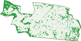
Green: 10 m cells where trees dominate, satellite 2021. Blue: water. The line is the suburb boundary.
| Canopy share, 1 m canopy height map, 2020 | 6.6% |
|---|---|
| Land with trees, 10 m satellite map, 2021 | 16.5% |
Demographics
Unemployment 4.5% · Labour-force participation 58.8%
Population by age in Keilor East
| 0-4 | 807 |
|---|---|
| 5-14 | 1,839 |
| 15-19 | 876 |
| 20-24 | 737 |
| 25-34 | 1,642 |
| 35-44 | 1,950 |
| 45-54 | 2,139 |
| 55-64 | 1,651 |
| 65-74 | 1,479 |
| 75-84 | 1,451 |
| 85+ | 514 |
Dwelling types in Keilor East
| House | 4,390 |
|---|---|
| Townhouse | 1,003 |
| Apartment | 46 |
| Other | 11 |
Households by weekly income in Keilor East
| <$650 | 849 |
|---|---|
| $650-1,499 | 1,283 |
| $1,500-2,999 | 1,551 |
| $3,000+ | 1,447 |
Top ancestries in Keilor East
| Italian | 3,688 |
|---|---|
| Australian | 3,157 |
| English | 3,008 |
| Other | 1,895 |
| Irish | 1,152 |
| Greek | 1,115 |
Housing tenure in Keilor East
| Owned | 2,505 |
|---|---|
| Mortgage | 1,769 |
| Rented | 1,022 |
| Other | 66 |
Cars per household in Keilor East
| 0 | 260 |
|---|---|
| 1 | 1,751 |
| 2 | 2,369 |
| 3 | 672 |
| 4+ | 337 |
Commute to work in Keilor East
| Car | 3,716 |
|---|---|
| Train | 69 |
| Bus | 28 |
| Tram/ferry | 4 |
| Walked | 48 |
| Bicycle | 16 |
| Home | 2,000 |
Top countries of birth in Keilor East
| Italy | 860 |
|---|---|
| Vietnam | 400 |
| India | 306 |
| Greece | 284 |
| England | 187 |
| China | 182 |
Languages used at home in Keilor East
| Italian | 1,279 |
|---|---|
| Greek | 739 |
| Vietnamese | 440 |
| Arabic | 297 |
| Mandarin | 232 |
| Cantonese | 230 |
Birds & Wildlife Nearby
90,561 bird observations recorded near Keilor East — most often seen:
- Little Raven (4,587)
- Rainbow Lorikeet (4,361)
- Australian Magpie (4,251)
- Red Wattlebird (4,099)
- Eurasian Blackbird (4,024)
- Magpie-lark (3,881)
- Pacific Black Duck (3,672)
- Common Starling (3,665)
- White-plumed Honeyeater (3,663)
- Common Myna (3,585)
- House Sparrow (3,432)
- Welcome Swallow (3,411)
- Superb Fairy-wren (3,403)
Show all 30 birds recorded near Keilor East
- Dusky Moorhen (3,365)
- Spotted Turtle-dove (3,299)
- Noisy Miner (3,259)
- Willie Wagtail (3,126)
- Rock Dove (3,029)
- New Holland Honeyeater (2,820)
- Crested Pigeon (2,254)
- Red-rumped Parrot (2,182)
- White-faced Heron (2,089)
- Little Pied Cormorant (2,070)
- Eurasian Coot (2,054)
- Chestnut Teal (1,973)
- Sulphur-crested Cockatoo (1,968)
- Red-browed Finch (1,940)
- Australian Wood Duck (1,776)
- Silver Gull (1,771)
- Galah (1,552)
Sightings reported by observers, not a survey, so the counts show what people record rather than what lives here. Source: Atlas of Living Australia.
Nearby Suburbs
The closest suburbs to Keilor East:
- Niddrie (1.8 km)
- Essendon West (2.2 km)
- Avondale Heights (2.3 km)
- Airport West (2.5 km)
- Keilor Park (2.5 km)
- Essendon North (3.2 km)
- Aberfeldie (3.3 km)
- Essendon Fields (3.4 km)
Embed this suburb
Add this free Keilor East stat card to your own site — just copy the code:
Preview:
Cite this page
Quoting these figures? Copy the credit line:
Keep an eye on Keilor East
One email when this data meaningfully changes — new census figures, prices, rankings. No spam, unsubscribe anytime.
Streets
- Alwyn Court (8)
- Amis Crescent (19)
- Anthony Court (15)
- Arcade Square (9)
- Arcade Way (68)
- Arete Place (3)
- Armstrong Close (25)
- Ash Grove (48)
- Bailey Avenue (30)
- Basalt Avenue (54)
- Beckett Avenue (34)
- Bellarine Avenue (20)
- Belle Vista (16)
- Benaud Close (28)
- Berembong Drive (87)
- Bernard Court (26)
- Boardwalk Place (38)
- Bond Court (5)
- Border Drive (66)
- Borva Drive (69)
- Bradman Boulevard (2)
- Brees Road (155)
- Brimbank Road (3)
- Britt Court (20)
- Buckley Street (69)
- Burley Griffin Close (14)
- Byron Avenue (23)
- Cain Avenue (11)
- Cain Court (7)
- Carey Court (15)
- Cecelia Drive (47)
- Cemetery Road (4)
- Centreway (59)
- Chandler Street (27)
- Chappell Place (39)
- Clarks Road (71)
- Clover Court (7)
- Cohen Street (43)
- College Parade (14)
- Collendina Close (14)
- Collins Close (20)
- Commercial Place (56)
- Craig Street (58)
- Cresta Court (4)
- Cudgewa Place (24)
- Dali Court (6)
- Darling Close (24)
- David Avenue (114)
- Dennis Avenue (42)
- Devon Avenue (6)
- Dinah Parade (127)
- Diorite Court (17)
- Disney Avenue (45)
- Doctors Lane (4)
- Dodds Road (3)
- Dorset Avenue (8)
- Drew Street (26)
- Eastleigh Avenue (55)
- Ellemaree Court (7)
- Ellen Avenue (46)
- Ely Court (13)
- Etka Avenue (34)
- Exchange Close (1)
- Falcon Lane (4)
- Fawkner Crescent (83)
- Giuliano Court (7)
- Glen Court (4)
- Grandvalley Drive (23)
- Granite Way (40)
- Grant Grove (20)
- Grantchester Avenue (21)
- Groves Street (28)
- Gungarlan Drive (49)
- Harley Court (9)
- Harvey Court (8)
- Hassett Crescent (110)
- Hawthorn Court (15)
- Heather Avenue (66)
- Heatherlea Crescent (41)
- Hedgerow Court (17)
- Henry Street (63)
- Herbert Crescent (38)
- Hilltop Court (6)
- Holland Court (245)
- Holly Green Court (18)
- Janet Street (33)
- Jeffrey Street (31)
- Judith Street (32)
- Keilor Park Drive (65)
- Keith Grove (23)
- Knoll Place (17)
- Lakeside Crescent (24)
- Lauricella Avenue (45)
- Lawry Court (11)
- Ledge Walk (6)
- Lemmon Avenue (17)
- Limestone Avenue (28)
- Lincoln Drive (140)
- Mainridge Vista (16)
- Manyung Court (6)
- Mark Street (43)
- Maurice Court (14)
- Mcfarlane Street (49)
- Mcpherson Street (39)
- Medway Road (15)
- Menzies Place (2)
- Milleara Road (359)
- Moyangul Drive (28)
- Mues Street (25)
- Murdoch Court (17)
- Neal Street (31)
- Neville Street (52)
- Nicholas Court (25)
- Nicola Court (28)
- Noble Court (7)
- Noga Avenue (169)
- Norwood Drive (66)
- Nyah Street (105)
- Old Calder Highway (9)
- Olivine Road (49)
- Outlook Court (6)
- Overland Place (23)
- Pamela Avenue (18)
- Park Drive (84)
- Parkside Avenue (114)
- Patricia Street (58)
- Paul Avenue (51)
- Pebble Court (3)
- Pennington Street (46)
- Peregrine Rise (3)
- Phillip Road (80)
- Prendergast Avenue (1)
- Prospect Drive (117)
- Pumice Court (27)
- Quartz Court (15)
- Quinn Grove (165)
- Rachelle Road (193)
- Regent Street (32)
- Rim Cross Drive (59)
- Riverside Place (24)
- Roberts Street (95)
- Ronald Grove (17)
- Rosehill Road (65)
- Rostella Crescent (23)
- Rotary Drive (2)
- Saltau Street (19)
- Scurrah Court (20)
- Shelley Street (68)
- Short Street (16)
- Simpson Place (20)
- Slater Parade (185)
- St Bernards Drive (36)
- Steele Creek Drive (73)
- Sterling Drive (261)
- Stroner Avenue (26)
- Surrey Drive (96)
- Susan Court (16)
- Talbot Street (22)
- Talus Court (16)
- The Crossway (108)
- The Strand (17)
- Thor Court (46)
- Trent Court (6)
- Trott Place (13)
- Tudor Court (9)
- Tunnecliffe Court (7)
- Tuppal Place (33)
- Urana Drive (27)
- Valley Lake Boulevard (95)
- Victoria Street (121)
- Viewbank Drive (24)
- Vista Drive (42)
- Warren Court (21)
- Webber Parade (85)
- West Gateway (53)
- Westleigh Place (20)
- Williams Avenue (24)
- Wingara Avenue (139)
- Wonganella Drive (98)
- Woodfull Court (16)
- Woorigoleen Drive (39)
- Woorite Place (65)
- Wunnamurra Drive (49)
- Wyong Street (131)
- Yallop Court (23)
- Yetta Court (3)