Pascoe Vale South VIC 3044
5,083 addresses · 102 streets
Wills Electorate › Moreland LGA › Pascoe Vale South · 8 km from Melbourne
📦 Thinking of moving here? Read the Pascoe Vale South moving guide

Living Here
Pascoe Vale South is a suburb of Victoria, home to about 10,534 people, with a median age of 39. The typical household earns around $2,246 a week, with median rent near $425 a week. Most homes are houses. About 75% of households own their home and 24% rent. Most workers drive to work. Common community backgrounds include English, Italian, Australian. On the ABS socio-economic scale it sits in decile 10 of 10 nationally — a relatively advantaged area. The median house sells for about $1,222,500.
Over time — Census 2001 → 2021
Dashed line: district figures for the Pascoe Vale South statistical area (SA2), the smallest area the ABS published before 2011. Solid line: Pascoe Vale South itself.
Getting Around & Local Services
82 schools
- Antonine College Saint Joseph Campus
- Pascoe Vale South Primary School
- Coburg West Primary School
- Strathmore Secondary College
- St Vincent de Paul Primary School
- Pascoe Vale Primary School
- St Fidelis' Primary School
- Coburg North Primary School
- St Oliver Plunkett Primary School
- Coburg Special Development School
35 doctors & medical clinics
- Bell Street Family Medical Centre
- Pascoe Vale Medical Centre
- BareBody
- Medispa
- Merri-bek Family Doctors
- Doctors of Coburg North
- ReGen Uniting Care
- Dorset Specialist Centre
- Coburg Central Medical Centre
- Coburg Endoscopy Centre
See all 35 doctors & medical clinics near Pascoe Vale South →
28 childcare & kindergartens
- Pascoe Vale South Uniting Church Kindergarten
- Coburg and Pascoe Vale South Childcare
- Doris Blackburn Early Years Centre (MCH & Preschool)
- Mary Poppins Childcare and Preschool
- Dunstan Reserve Moreland Community Childcare Centres
- Brunswick Montessori Children's House
- Goodstart Early Learning Centre (West)
- Goodstart Early Learning Centre
- Eden academy Childcare & kindergarten
- Montgomery Park Childrens Centre
See all 28 childcare & kindergartens near Pascoe Vale South →
Getting around. Train station: Strathmore, 1.1 km west · Tram stop: Stop 43: Princes Terrace, 550 m east · Bus interchange: Highpoint Shopping Centre, 5.6 km south-west · Airport: Essendon Fields Airport, 4 km north-west.
Sport & Recreation
3 facilities recorded in Pascoe Vale South.
- Brearley Reserve Australian Rules Football, Cricket
- Morris Reserve Australian Rules Football, Cricket
- Shore Reserve Australian Rules Football, Cricket
Socio-economic Standing
Deciles from 1 (lowest) to 10 (highest), against all Australian suburbs. The overall figure weighs advantage and disadvantage together; economic resources counts income and housing, and education & jobs counts qualifications and occupation. They often differ. Source: ABS SEIFA 2021.
Median Sale Prices
Median of recorded sales in the period, not a valuation. Source: Victorian Property Sales Report, Land Use Victoria.
Tree cover
🌳 Tree canopy: 5.5% share of land under canopy · satellite map, 2020
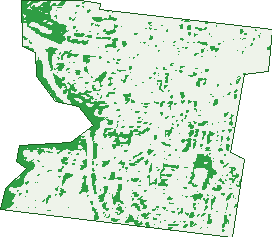
Green: 10 m cells where trees dominate, satellite 2021. Blue: water. The line is the suburb boundary.
| Canopy share, 1 m canopy height map, 2020 | 5.5% |
|---|---|
| Land with trees, 10 m satellite map, 2021 | 12.0% |
Demographics
Unemployment 3.7% · Labour-force participation 68.6%
Population by age in Pascoe Vale South
| 0-4 | 547 |
|---|---|
| 5-14 | 1,374 |
| 15-19 | 652 |
| 20-24 | 617 |
| 25-34 | 1,354 |
| 35-44 | 1,591 |
| 45-54 | 1,585 |
| 55-64 | 1,264 |
| 65-74 | 755 |
| 75-84 | 458 |
| 85+ | 335 |
Dwelling types in Pascoe Vale South
| House | 3,051 |
|---|---|
| Townhouse | 417 |
| Apartment | 314 |
| Other | 6 |
Households by weekly income in Pascoe Vale South
| <$650 | 467 |
|---|---|
| $650-1,499 | 738 |
| $1,500-2,999 | 1,090 |
| $3,000+ | 1,288 |
Top ancestries in Pascoe Vale South
| English | 2,467 |
|---|---|
| Italian | 2,448 |
| Australian | 2,443 |
| Other | 1,352 |
| Greek | 1,199 |
| Irish | 1,195 |
Housing tenure in Pascoe Vale South
| Owned | 1,398 |
|---|---|
| Mortgage | 1,420 |
| Rented | 902 |
| Other | 29 |
Cars per household in Pascoe Vale South
| 0 | 264 |
|---|---|
| 1 | 1,363 |
| 2 | 1,511 |
| 3 | 399 |
| 4+ | 216 |
Commute to work in Pascoe Vale South
| Car | 2,460 |
|---|---|
| Train | 76 |
| Bus | 11 |
| Tram/ferry | 99 |
| Walked | 53 |
| Bicycle | 65 |
| Home | 2,046 |
Top countries of birth in Pascoe Vale South
| Italy | 497 |
|---|---|
| Greece | 286 |
| England | 154 |
| India | 122 |
| New Zealand | 118 |
| China | 85 |
Languages used at home in Pascoe Vale South
| Greek | 846 |
|---|---|
| Italian | 829 |
| Arabic | 213 |
| Mandarin | 120 |
| Vietnamese | 114 |
| Spanish | 104 |
Birds & Wildlife Nearby
223,519 bird observations recorded near Pascoe Vale South — most often seen:
- Common Myna (12,715)
- Rainbow Lorikeet (12,459)
- Red Wattlebird (11,458)
- Little Raven (10,623)
- Magpie-lark (10,341)
- Noisy Miner (10,305)
- Spotted Turtle-dove (9,896)
- Eurasian Blackbird (9,626)
- Australian Magpie (9,590)
- Rock Dove (9,156)
- Dusky Moorhen (8,735)
- Pacific Black Duck (8,686)
- Common Starling (7,784)
Show all 30 birds recorded near Pascoe Vale South
- Silver Gull (7,424)
- White-plumed Honeyeater (7,097)
- Welcome Swallow (6,935)
- Crested Pigeon (6,595)
- House Sparrow (5,715)
- Willie Wagtail (5,679)
- Superb Fairy-wren (5,652)
- Eurasian Coot (5,381)
- Australian White Ibis (5,340)
- Chestnut Teal (5,203)
- New Holland Honeyeater (5,151)
- Grey Butcherbird (4,879)
- Australian Wood Duck (4,550)
- Galah (4,421)
- Pied Currawong (4,408)
- Little Pied Cormorant (3,934)
- Little Wattlebird (3,781)
Sightings reported by observers, not a survey, so the counts show what people record rather than what lives here. Source: Atlas of Living Australia.
Nearby Suburbs
The closest suburbs to Pascoe Vale South:
- Pascoe Vale (2 km)
- Brunswick West (2.2 km)
- Coburg (2.2 km)
- Strathmore (2.3 km)
- Essendon (2.5 km)
- Moonee Ponds (3 km)
- Coburg North (3.1 km)
- Essendon North (3.3 km)
Embed this suburb
Add this free Pascoe Vale South stat card to your own site — just copy the code:
Preview:
Cite this page
Quoting these figures? Copy the credit line:
Keep an eye on Pascoe Vale South
One email when this data meaningfully changes — new census figures, prices, rankings. No spam, unsubscribe anytime.
Streets
- Aberdeen Street (13)
- Acacia Grove (23)
- Anderson Street (64)
- Balmoral Avenue (116)
- Bell Street (307)
- Beresford Street (16)
- Braemar Street (2)
- Brearley Parade (9)
- Brentwood Avenue (71)
- Briar Place (13)
- Cantala Street (39)
- Carrington Street (57)
- Cleve Road (26)
- Coonans Road (88)
- Cumberland Road (272)
- Dace Court (4)
- Dale Avenue (2)
- Davern Street (26)
- Dickens Street (22)
- Disraeli Grove (49)
- Eastgate Street (132)
- Elgin Street (9)
- Ellenvale Avenue (45)
- Eunice Court (4)
- Fontaine Street (35)
- Forster Court (13)
- Francis Street (2)
- Frey Street (3)
- Gallipoli Parade (81)
- Gezireh Street (40)
- Graham Street (46)
- Grandview Avenue (111)
- Greenbank Crescent (29)
- Greenwood Street (56)
- Grundy Grove (50)
- Hackett Street (62)
- Hatter Street (60)
- Hayward Street (6)
- Heliopolis Street (22)
- Henley Street (66)
- Hillview Avenue (4)
- Irvine Street (2)
- Jhonson Street (45)
- Kathleen Street (34)
- Kernan Street (4)
- Kinross Street (2)
- Langtree Avenue (39)
- Lansdowne Street (46)
- Le Cateau Street (28)
- Lemnos Avenue (7)
- Lochinvar Street (24)
- Lothair Street (34)
- Louisville Avenue (34)
- Magdalen Street (28)
- Marsden Avenue (22)
- Mckeon Avenue (35)
- Melville Road (224)
- Milton Street (12)
- Mitchell Parade (103)
- Moama Crescent (15)
- Moascar Street (26)
- Moreland Road (106)
- Murray Street (2)
- Myers Street (8)
- Northgate Street (13)
- Ohea Street (306)
- Parkside Boulevard (23)
- Parkstone Avenue (89)
- Peppercorn Terrace (11)
- Peronne Street (31)
- Power Street (28)
- Prendergast Street (56)
- Princes Terrace (10)
- Purches Avenue (34)
- Rainer Street (58)
- Reynard Street (130)
- Reynolds Parade (136)
- Royal Parade (126)
- Somali Street (34)
- Soudan Street (2)
- Springhall Parade (116)
- Sussex Street (59)
- Tate Street (18)
- The Boulevard (45)
- The Lane (2)
- Thistle Street (15)
- Turner Street (44)
- Vaux Street (25)
- Vimy Court (7)
- Wadham Street (28)
- Walhalla Street (26)
- Ward Grove (68)
- Warren Street (24)
- Waverley Parade (102)
- Wentworth Avenue (2)
- Westgate Street (208)
- Wheeler Street (38)
- Wills Street (12)
- Winifred Street (36)
- Winona Grove (32)
- Woodlands Avenue (66)
- York Street (48)