Pascoe Vale VIC 3044
10,560 addresses · 169 streets
Wills Electorate › Moreland LGA › Pascoe Vale · 10 km from Melbourne
📦 Thinking of moving here? Read the Pascoe Vale moving guide

Living Here
An established inner-northern Melbourne suburb, Pascoe Vale is leafy, residential and rail-connected. Households average 2.4 people and the median age is 36. Median household income is $2,025 a week, with rent around $400.
Pascoe Vale is a suburb of Victoria, home to about 18,171 people, with a median age of 36. The typical household earns around $2,025 a week, with median rent near $400 a week. Most homes are townhouses. About 64% of households own their home and 35% rent. Most workers drive to work. Common community backgrounds include Australian, English, Italian. On the ABS socio-economic scale it sits in decile 9 of 10 nationally — a relatively advantaged area. The median house sells for about $1,047,500.
Over time — Census 2001 → 2021
Dashed line: district figures for the Pascoe Vale statistical area (SA2), the smallest area the ABS published before 2011. Solid line: Pascoe Vale itself.
Getting Around & Local Services
70 schools
- Pascoe Vale Primary School
- St Oliver Plunkett Primary School
- Pascoe Vale Girls' Secondary College
- Westbreen Primary School
- Pascoe Vale North Primary School
- St Francis de Sales Primary School
- Coburg Special Development School
- Strathmore Secondary College
- Coburg North Primary School
- Antonine College Saint Joseph Campus
19 childcare & kindergartens
- Guardian Childcare and Education Centre
- Kent Road Kindergarten
- Goodstart Early Learning Centre
- Goodstart Early Learning Centre (West)
- Eden academy Childcare & kindergarten
- South Street Early Learning Centre
- Pascoe Vale South Uniting Church Kindergarten
- Mary Poppins Childcare and Preschool
- Strathmore Children's Centre
- Coburg and Pascoe Vale South Childcare
2 playgrounds
2 electricians
Getting around. Train station: Pascoe Vale, 1.1 km south-west · Tram stop: Stop 45: Bell Street, 1.9 km south · Bus interchange: Highpoint Shopping Centre, 6.9 km south-west · Airport: Essendon Fields Airport, 3.3 km west.
Sport & Recreation
6 facilities recorded in Pascoe Vale.
- Cole Reserve Australian Rules Football, Cricket, Soccer
- Hallam Reserve Cricket, Soccer
- Oak Park Aquatic Centre Swimming
- Pascoe Vale Outdoor Pool Swimming
- Raeburn Reserve Australian Rules Football, Cricket
- Rayner Reserve Cricket, Soccer
Socio-economic Standing
Deciles from 1 (lowest) to 10 (highest), against all Australian suburbs. The overall figure weighs advantage and disadvantage together; economic resources counts income and housing, and education & jobs counts qualifications and occupation. They often differ. Source: ABS SEIFA 2021.
Median Sale Prices
Median of recorded sales in the period, not a valuation. Source: Victorian Property Sales Report, Land Use Victoria.
Tree cover
🌳 Tree canopy: 4.9% share of land under canopy · satellite map, 2020
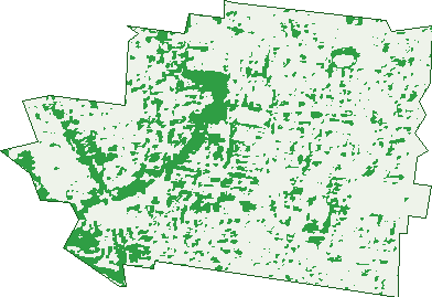
Green: 10 m cells where trees dominate, satellite 2021. Blue: water. The line is the suburb boundary.
| Canopy share, 1 m canopy height map, 2020 | 4.9% |
|---|---|
| Land with trees, 10 m satellite map, 2021 | 15.9% |
Demographics
Unemployment 4.8% · Labour-force participation 68.1%
Population by age in Pascoe Vale
| 0-4 | 1,143 |
|---|---|
| 5-14 | 2,045 |
| 15-19 | 829 |
| 20-24 | 1,037 |
| 25-34 | 3,480 |
| 35-44 | 3,118 |
| 45-54 | 2,315 |
| 55-64 | 1,698 |
| 65-74 | 1,091 |
| 75-84 | 756 |
| 85+ | 653 |
Dwelling types in Pascoe Vale
| House | 3,418 |
|---|---|
| Townhouse | 3,482 |
| Apartment | 208 |
| Other | 24 |
Households by weekly income in Pascoe Vale
| <$650 | 1,014 |
|---|---|
| $650-1,499 | 1,480 |
| $1,500-2,999 | 2,295 |
| $3,000+ | 1,970 |
Top ancestries in Pascoe Vale
| Australian | 3,966 |
|---|---|
| English | 3,873 |
| Italian | 3,433 |
| Other | 3,376 |
| Irish | 1,678 |
| Scottish | 1,206 |
Housing tenure in Pascoe Vale
| Owned | 2,023 |
|---|---|
| Mortgage | 2,444 |
| Rented | 2,485 |
| Other | 80 |
Cars per household in Pascoe Vale
| 0 | 545 |
|---|---|
| 1 | 3,217 |
| 2 | 2,443 |
| 3 | 574 |
| 4+ | 274 |
Commute to work in Pascoe Vale
| Car | 4,403 |
|---|---|
| Train | 351 |
| Bus | 38 |
| Tram/ferry | 31 |
| Walked | 71 |
| Bicycle | 70 |
| Home | 3,236 |
Top countries of birth in Pascoe Vale
| Italy | 717 |
|---|---|
| India | 534 |
| England | 330 |
| New Zealand | 265 |
| Greece | 238 |
| China | 232 |
Languages used at home in Pascoe Vale
| Italian | 1,161 |
|---|---|
| Greek | 676 |
| Arabic | 666 |
| Mandarin | 360 |
| Turkish | 354 |
| Urdu | 239 |
Birds & Wildlife Nearby
157,145 bird observations recorded near Pascoe Vale — most often seen:
- Common Myna (8,505)
- Little Raven (8,203)
- Rainbow Lorikeet (7,932)
- Red Wattlebird (7,500)
- Eurasian Blackbird (7,291)
- Magpie-lark (6,924)
- Australian Magpie (6,855)
- Spotted Turtle-dove (6,720)
- Rock Dove (6,507)
- Pacific Black Duck (6,409)
- Common Starling (6,082)
- Dusky Moorhen (5,973)
- Noisy Miner (5,713)
Show all 30 birds recorded near Pascoe Vale
- White-plumed Honeyeater (4,875)
- Australian White Ibis (4,658)
- Welcome Swallow (4,534)
- Eurasian Coot (4,455)
- Crested Pigeon (4,324)
- Silver Gull (4,324)
- House Sparrow (4,315)
- New Holland Honeyeater (3,979)
- Little Pied Cormorant (3,933)
- Willie Wagtail (3,822)
- Australian Wood Duck (3,811)
- Grey Butcherbird (3,480)
- Superb Fairy-wren (3,476)
- Chestnut Teal (3,448)
- Galah (3,117)
- White-faced Heron (3,066)
- Pied Currawong (2,914)
Sightings reported by observers, not a survey, so the counts show what people record rather than what lives here. Source: Atlas of Living Australia.
Nearby Suburbs
The closest suburbs to Pascoe Vale:
- Oak Park (1.8 km)
- Hadfield (1.8 km)
- Pascoe Vale South (2 km)
- Strathmore (2.1 km)
- Coburg North (2.7 km)
- Glenroy (2.7 km)
- Coburg (3.2 km)
- Essendon Fields (3.3 km)
Embed this suburb
Add this free Pascoe Vale stat card to your own site — just copy the code:
Preview:
Cite this page
Quoting these figures? Copy the credit line:
Keep an eye on Pascoe Vale
One email when this data meaningfully changes — new census figures, prices, rankings. No spam, unsubscribe anytime.
Streets
- Adelaide Street (19)
- Alexandra Street (44)
- Alpine Grove (118)
- Alwyn Street (14)
- Amber Court (20)
- Anderson Street (15)
- Ann Street (26)
- Archibald Street (64)
- Arndt Road (152)
- Arnold Court (42)
- Ash Court (14)
- Ashkanasy Avenue (18)
- Attercliffe Avenue (18)
- Austin Crescent (237)
- Avoca Crescent (40)
- Bass Street (9)
- Bawden Court (37)
- Bellevue Terrace (35)
- Bendigo Street (27)
- Bignell Street (3)
- Birch Court (19)
- Bolingbroke Street (161)
- Boronia Street (20)
- Bothwell Street (26)
- Boundary Road (460)
- Bradley Street (13)
- Braeside Street (20)
- Bridges Avenue (2)
- Bristol Road (104)
- Bryan Court (13)
- Burgundy Street (27)
- Callander Road (85)
- Camdon Street (27)
- Caringa Street (49)
- Casuarina Court (21)
- Cedar Court (10)
- Coane Street (21)
- Collings Court (11)
- Colorado Street (27)
- Cornwall Road (102)
- Crowley Court (20)
- Cumberland Road (495)
- Dale Avenue (54)
- Daley Street (34)
- Danin Street (206)
- Daphne Street (18)
- Derby Street (345)
- Devon Road (149)
- Dixon Street (23)
- Donnelly Court (17)
- Dorothy Street (10)
- Dorset Road (61)
- Douglas Street (27)
- Downs Street (63)
- Dromana Avenue (21)
- Earls Court (6)
- Eddie Street (30)
- Edmunds Court (7)
- Erica Street (16)
- Essex Street (262)
- Evelyn Street (23)
- Farringdon Street (51)
- Fawkner Road (111)
- Fleming Grove (13)
- Frey Street (10)
- Gaffney Street (500)
- Gilmour Court (9)
- Grevillia Road (5)
- Grover Street (62)
- Gyles Street (15)
- Hayes Parade (24)
- Hazel Grove (124)
- Heath Street (48)
- Heathcote Street (18)
- Heather Avenue (20)
- Herbert Street (16)
- Irene Avenue (6)
- Irma Grove (17)
- Irvine Street (46)
- Joffre Road (64)
- John Street (6)
- Karadoc Avenue (15)
- Kaumple Street (23)
- Kent Road (230)
- Keogh Court (15)
- Kevin Street (21)
- Kinross Street (53)
- Kirbister Street (41)
- Kitchener Road (89)
- Lake Avenue (42)
- Landells Road (222)
- Lillian Street (19)
- Lily Street (4)
- Longview Street (39)
- Lyking Street (25)
- Madoline Street (12)
- Main Street (37)
- Marks Street (11)
- Martin Street (53)
- Mccracken Avenue (59)
- Mcgregor Street (16)
- Mcloughlin Court (6)
- Merbein Street (44)
- Millson Court (9)
- Nerissa Grove (2)
- Northgate Street (39)
- Northumberland Road (410)
- Norton Street (13)
- Oak Street (30)
- Oakbank Grove (24)
- Ohea Street (5)
- Olive Grove (64)
- Ormond Street (50)
- Pardy Street (130)
- Park Street (281)
- Parker Street (80)
- Pascoe Street (279)
- Pascoe Vale Road (194)
- Peachey Court (24)
- Pearcey Grove (21)
- Penzance Street (4)
- Perkin Avenue (35)
- Pleasant Street (90)
- Plymouth Avenue (94)
- Princess Street (36)
- Prospect Street (98)
- Quick Street (82)
- Raeburn Street (42)
- Railway Parade (146)
- Ray Street (36)
- Rhodes Parade (48)
- Rising Street (6)
- Rollo Street (4)
- Rose Street (42)
- Sage Street (16)
- Sefton Street (72)
- Shanley Street (47)
- Shedden Street (41)
- Sims Street (40)
- Snell Grove (122)
- Somerset Street (27)
- South Street (2)
- Stanley Street (24)
- Stennis Street (54)
- Stewart Street (57)
- Stock Court (3)
- Sunbeam Street (16)
- Sunshine Street (39)
- Surrey Street (163)
- Sussex Street (349)
- Sylvan Grove (88)
- Tangyes Street (37)
- Thickins Street (6)
- Tonkin Avenue (1)
- Vale Street (30)
- Valerie Street (34)
- View Street (172)
- Virginia Street (19)
- Waratah Street (31)
- Warwick Road (121)
- Waterloo Road (2)
- Watt Avenue (3)
- West Street (41)
- Wicklow Street (41)
- Wilna Street (11)
- Windsor Street (42)
- Wonga Avenue (13)
- Yorkshire Street (26)
- Zenith Street (54)