Essendon VIC 3040
13,055 addresses · 147 streets
Maribyrnong Electorate › Moonee Valley LGA › Essendon · 8 km from Melbourne
📦 Thinking of moving here? Read the Essendon moving guide

Living Here
An established inner-north-western Melbourne suburb known for its period homes and tree-lined streets, Essendon is comfortable and well-connected. Households average 2.4 people and the median age is 39. Median household income is $2,132 a week, with rent around $380.
Essendon is a suburb of Victoria, home to about 21,240 people, with a median age of 39. The typical household earns around $2,132 a week, with median rent near $380 a week. Most homes are houses. About 63% of households own their home and 36% rent. Most workers drive to work. Common community backgrounds include English, Australian, Italian. On the ABS socio-economic scale it sits in decile 10 of 10 nationally — a relatively advantaged area. The median house sells for about $1,741,500.
Over time — Census 2001 → 2021
Dashed line: district figures for the Essendon - Aberfeldie statistical area (SA2), the smallest area the ABS published before 2011. Solid line: Essendon itself.
Getting Around & Local Services
74 schools
- St Therese's Primary School
- Penleigh and Essendon Grammar School Essendon Campus
- St Columba's College
- Essendon Primary School
- Essendon Keilor College Essendon Campus
- Lowther Hall Anglican Grammar School
- Essendon North Primary School
- Buckley Park College
- Penleigh and Essendon Grammar School Moonee Ponds Campus
- St Vincent de Paul Primary School
1 playground
Getting around. Train station: Essendon, 800 m south-east · Tram stop: Stop 44: Thorn Street, 200 m north-east · Bus interchange: Highpoint Shopping Centre, 3.3 km south-west · Airport: Essendon Fields Airport, 2.9 km north.
Sport & Recreation
12 facilities recorded in Essendon, the first 10 below.
- Aberfeldie Bowls Club Lawn Bowls
- Buckley Park Australian Rules Football, Cricket, Tennis (Outdoor)
- Buckley Park Bowls Club Lawn Bowls
- Cross Keys Reserve Cricket
- Essendon Bowls Club Lawn Bowls
- Essendon Christ Church Badminton Club Badminton
- Essendon Cricket Ground Australian Rules Football, Cricket, Croquet
- Fighting Lyons Taekwondo Health & Fitness Centre Aerobics, Boxing, Fitness / Gymnasium Workouts, Gymnastics, Tae Kwon Do
- Fitness First Essendon Aerobics, Fitness / Gymnasium Workouts
- Seymour's Pool Swimming
Socio-economic Standing
Deciles from 1 (lowest) to 10 (highest), against all Australian suburbs. The overall figure weighs advantage and disadvantage together; economic resources counts income and housing, and education & jobs counts qualifications and occupation. They often differ. Source: ABS SEIFA 2021.
Median Sale Prices
Median of recorded sales in the period, not a valuation. Source: Victorian Property Sales Report, Land Use Victoria.
Tree cover
🌳 Tree canopy: 5.8% share of land under canopy · satellite map, 2020
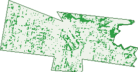
Green: 10 m cells where trees dominate, satellite 2021. Blue: water. The line is the suburb boundary.
| Canopy share, 1 m canopy height map, 2020 | 5.8% |
|---|---|
| Land with trees, 10 m satellite map, 2021 | 11.8% |
Demographics
Unemployment 4.2% · Labour-force participation 69%
Population by age in Essendon
| 0-4 | 865 |
|---|---|
| 5-14 | 2,312 |
| 15-19 | 1,225 |
| 20-24 | 1,588 |
| 25-34 | 3,300 |
| 35-44 | 2,938 |
| 45-54 | 3,028 |
| 55-64 | 2,629 |
| 65-74 | 1,870 |
| 75-84 | 962 |
| 85+ | 533 |
Dwelling types in Essendon
| House | 4,019 |
|---|---|
| Townhouse | 1,671 |
| Apartment | 2,810 |
| Other | 18 |
Households by weekly income in Essendon
| <$650 | 1,053 |
|---|---|
| $650-1,499 | 1,797 |
| $1,500-2,999 | 2,455 |
| $3,000+ | 2,809 |
Top ancestries in Essendon
| English | 5,649 |
|---|---|
| Australian | 5,030 |
| Italian | 3,464 |
| Other | 2,942 |
| Irish | 2,894 |
| Scottish | 1,751 |
Housing tenure in Essendon
| Owned | 2,760 |
|---|---|
| Mortgage | 2,527 |
| Rented | 3,037 |
| Other | 119 |
Cars per household in Essendon
| 0 | 763 |
|---|---|
| 1 | 3,760 |
| 2 | 2,690 |
| 3 | 777 |
| 4+ | 455 |
Commute to work in Essendon
| Car | 5,036 |
|---|---|
| Train | 366 |
| Bus | 49 |
| Tram/ferry | 169 |
| Walked | 199 |
| Bicycle | 81 |
| Home | 4,166 |
Top countries of birth in Essendon
| India | 633 |
|---|---|
| Italy | 512 |
| England | 377 |
| China | 279 |
| New Zealand | 278 |
| Nepal | 262 |
Languages used at home in Essendon
| Italian | 906 |
|---|---|
| Greek | 504 |
| Mandarin | 366 |
| Vietnamese | 298 |
| Arabic | 266 |
| Nepali | 254 |
Birds & Wildlife Nearby
183,170 bird observations recorded near Essendon — most often seen:
- Common Myna (9,276)
- Rainbow Lorikeet (9,274)
- Red Wattlebird (8,406)
- Magpie-lark (8,152)
- Little Raven (8,144)
- Australian Magpie (7,671)
- Spotted Turtle-dove (7,551)
- Noisy Miner (7,504)
- Pacific Black Duck (7,450)
- Dusky Moorhen (7,191)
- Common Starling (7,133)
- Rock Dove (7,066)
- Welcome Swallow (6,693)
Show all 30 birds recorded near Essendon
- White-plumed Honeyeater (6,688)
- Eurasian Blackbird (6,666)
- Silver Gull (5,947)
- Superb Fairy-wren (5,879)
- Chestnut Teal (5,680)
- Eurasian Coot (5,671)
- House Sparrow (5,404)
- Willie Wagtail (5,198)
- Crested Pigeon (5,094)
- New Holland Honeyeater (5,008)
- Australasian Purple Swamphen (4,739)
- Little Pied Cormorant (3,815)
- White-faced Heron (3,520)
- Galah (3,157)
- Red-rumped Parrot (3,154)
- Australian White Ibis (3,113)
- Australasian Grebe (2,926)
Sightings reported by observers, not a survey, so the counts show what people record rather than what lives here. Source: Atlas of Living Australia.
Nearby Suburbs
The closest suburbs to Essendon:
- Essendon North (1.4 km)
- Aberfeldie (1.6 km)
- Strathmore (1.8 km)
- Moonee Ponds (1.9 km)
- Essendon West (2.2 km)
- Pascoe Vale South (2.5 km)
- Niddrie (2.6 km)
- Essendon Fields (2.8 km)
Embed this suburb
Add this free Essendon stat card to your own site — just copy the code:
Preview:
Cite this page
Quoting these figures? Copy the credit line:
Keep an eye on Essendon
One email when this data meaningfully changes — new census figures, prices, rankings. No spam, unsubscribe anytime.
Streets
- Aberdeen Crescent (13)
- Agatha Street (34)
- Albion Street (70)
- Alfred Road (39)
- Amelia Avenue (48)
- Ardoch Street (89)
- Ballater Street (92)
- Balmoral Street (64)
- Banchory Street (40)
- Black Street (18)
- Bradshaw Street (214)
- Braemar Street (75)
- Brewster Street (93)
- Bridge Street (8)
- Buckley Street (553)
- Bulla Road (16)
- Butler Street (45)
- Cameron Road (54)
- Carnarvon Road (15)
- Clarinda Road (76)
- Cliff Street (19)
- Cochrane Court (16)
- Coleman Mews (5)
- Collins Street (252)
- Cooke Street (24)
- Cooper Street (361)
- Crisp Street (26)
- Croft Street (8)
- Cudmore Street (23)
- Curtis Street (10)
- Daisy Street (102)
- Dalene Street (5)
- Deakin Street (301)
- Donald Avenue (58)
- Edward Street (64)
- Elder Parade (70)
- Eric Street (13)
- Fitzgerald Road (109)
- Fletcher Street (242)
- Florence Street (13)
- Flower Street (92)
- Forbes Street (36)
- Forrester Street (122)
- Fuller Street (29)
- Garden Street (25)
- Gibson Court (10)
- Gilbertson Street (74)
- Glass Street (448)
- Glen Street (39)
- Gordon Street (16)
- Government Road (12)
- Graves Street (79)
- Grice Crescent (117)
- Hedderwick Street (138)
- Hesleden Street (51)
- Hilda Street (25)
- Hoddle Street (82)
- Hoffmans Road (176)
- Inglebrae Court (6)
- Jacka Street (21)
- Kalimna Street (28)
- Keilor Road (275)
- Kendall Street (52)
- Kilmartin Street (13)
- King Street (89)
- Kiora Street (14)
- Laluma Street (39)
- Lawson Street (68)
- Leake Street (94)
- Leila Street (14)
- Leslie Road (59)
- Levien Street (36)
- Lincoln Road (210)
- Locke Street (33)
- Loeman Street (19)
- Lorraine Street (19)
- Lyon Street (54)
- Lyttle Avenue (16)
- Mackay Street (64)
- Marco Polo Street (53)
- Market Street (170)
- Mary Street (82)
- Mccarron Parade (43)
- Mccracken Street (121)
- Mchale Court (7)
- Mcphail Street (44)
- Mcpherson Street (86)
- Melfort Avenue (2)
- Miller Street (55)
- Monica Street (22)
- Moreland Road (124)
- Morton Street (35)
- Mountain Street (21)
- Mt Alexander Road (1,030)
- Napier Crescent (104)
- Napier Street (338)
- Nicholson Lane (2)
- Nicholson Street (97)
- Nimmo Street (152)
- Ogilvie Street (295)
- Overman Court (13)
- Park Street (1)
- Pascoe Vale Road (585)
- Peterleigh Grove (42)
- Price Street (117)
- Primrose Street (115)
- Queen Street (64)
- Raleigh Street (258)
- Richardson Street (252)
- Riverview Road (21)
- Robb Street (71)
- Roberts Street (252)
- Rose Street (121)
- Russell Street (227)
- Salmon Avenue (52)
- Salter Street (44)
- Schofield Street (108)
- Scott Street (74)
- Shaftesbury Street (39)
- Shamrock Street (10)
- Sherbourne Street (44)
- Spencer Street (175)
- Stanley Street (14)
- Sturt Street (65)
- Tennyson Street (98)
- Thistle Street (10)
- Thomson Street (51)
- Thorn Street (46)
- Tutton Lane (4)
- Tweedside Street (63)
- Vanberg Road (83)
- Violet Street (88)
- Warner Street (67)
- Washington Street (86)
- Waverley Street (31)
- Wentworth Avenue (8)
- Westgreen Court (4)
- Wheeler Place (16)
- William Street (83)
- Willow Street (34)
- Winifred Street (144)
- Wiseman Court (13)
- Woodland Street (152)
- Woodvale Close (25)
- Woodvale Grove (28)
- Woolley Street (54)
- Wright Street (49)