Melton VIC 3337
5,635 addresses · 171 streets
Hawke Electorate › Melton LGA › Melton · 36 km from Melbourne
📦 Thinking of moving here? Read the Melton moving guide

Living Here
Melton is a suburb of Victoria, home to about 7,953 people, with a median age of 40. The typical household earns around $1,058 a week, with median rent near $300 a week. Most homes are houses. About 64% of households own their home and 35% rent. Most workers drive to work. Common community backgrounds include Australian, English, Ancestry NS. On the ABS socio-economic scale it sits in decile 1 of 10 nationally — a more disadvantaged area. The median house sells for about $471,000.
Over time — Census 2001 → 2021
Dashed line: district figures for the Melton statistical area (SA2), the smallest area the ABS published before 2011. Solid line: Melton itself.
Getting Around & Local Services
6 cafés & restaurants
7 supermarkets
2 doctors & medical clinics
1 library
2 post offices
1 golf club
1 playground
1 dog park
2 bakeries
1 butcher
2 hardware stores
1 hairdresser
1 beauty salon
1 mechanic
2 places to stay
Getting around. Train station: Cobblebank, 3.6 km south-east · Bus interchange: Temporary Melton Station bus interchange, 2.4 km south-west · Airport: Melbourne Airport, 21.6 km east.
Sport & Recreation
9 facilities recorded in Melton.
- Body Style World of Health & Fitness Fitness / Gymnasium Workouts
- Fernwood Women's Health Clubs Fitness / Gymnasium Workouts
- Healthy Inspirations Melton Fitness / Gymnasium Workouts
- Melton Bowling Club Lawn Bowls
- Melton Recreation Reserve Australian Rules Football, Cricket, Netball, Skating, Tennis (Outdoor)
- Melton Squash Central Squash / Racquetball
- Melton Valley Golf Course Golf
- Melton Waves Leisure Centre Fitness / Gymnasium Workouts, Swimming
- Squash Logic Melton Squash / Racquetball
Socio-economic Standing
Deciles from 1 (lowest) to 10 (highest), against all Australian suburbs. The overall figure weighs advantage and disadvantage together; economic resources counts income and housing, and education & jobs counts qualifications and occupation. They often differ. Source: ABS SEIFA 2021.
Median Sale Prices
Median of recorded sales in the period, not a valuation. Source: Victorian Property Sales Report, Land Use Victoria.
Tree cover
🌳 Tree canopy: 2.9% share of land under canopy · satellite map, 2020
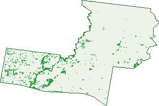
Green: 10 m cells where trees dominate, satellite 2021. Blue: water. The line is the suburb boundary.
| Canopy share, 1 m canopy height map, 2020 | 2.9% |
|---|---|
| Land with trees, 10 m satellite map, 2021 | 5.1% |
Demographics
Unemployment 9.6% · Labour-force participation 45.6%
Population by age in Melton
| 0-4 | 507 |
|---|---|
| 5-14 | 980 |
| 15-19 | 426 |
| 20-24 | 447 |
| 25-34 | 1,075 |
| 35-44 | 1,033 |
| 45-54 | 953 |
| 55-64 | 911 |
| 65-74 | 1,019 |
| 75-84 | 495 |
| 85+ | 109 |
Dwelling types in Melton
| House | 2,518 |
|---|---|
| Townhouse | 500 |
| Apartment | 3 |
| Other | 4 |
Households by weekly income in Melton
| <$650 | 746 |
|---|---|
| $650-1,499 | 1,137 |
| $1,500-2,999 | 737 |
| $3,000+ | 198 |
Top ancestries in Melton
| Australian | 2,303 |
|---|---|
| English | 2,288 |
| Other | 1,204 |
| Ancestry NS | 806 |
| Irish | 626 |
| Scottish | 535 |
Housing tenure in Melton
| Owned | 982 |
|---|---|
| Mortgage | 894 |
| Rented | 1,039 |
| Other | 36 |
Cars per household in Melton
| 0 | 286 |
|---|---|
| 1 | 1,311 |
| 2 | 899 |
| 3 | 302 |
| 4+ | 157 |
Commute to work in Melton
| Car | 1,764 |
|---|---|
| Train | 36 |
| Bus | 11 |
| Tram/ferry | 0 |
| Walked | 50 |
| Bicycle | 3 |
| Home | 337 |
Top countries of birth in Melton
| England | 212 |
|---|---|
| New Zealand | 212 |
| India | 176 |
| Philippines | 133 |
| Malta | 113 |
| Myanmar | 92 |
Languages used at home in Melton
| Vietnamese | 112 |
|---|---|
| Punjabi | 109 |
| Arabic | 76 |
| Samoan | 68 |
| Tagalog | 65 |
| Turkish | 64 |
Birds & Wildlife Nearby
13,400 bird observations recorded near Melton — most often seen:
- Common Myna (705)
- Little Raven (693)
- White-plumed Honeyeater (629)
- Red Wattlebird (623)
- Australian Magpie (608)
- Magpie-lark (598)
- Willie Wagtail (594)
- Pacific Black Duck (593)
- Rainbow Lorikeet (576)
- Crested Pigeon (538)
- Australian Wood Duck (537)
- Eurasian Blackbird (533)
- Common Starling (522)
Show all 30 birds recorded near Melton
- Red-rumped Parrot (507)
- New Holland Honeyeater (492)
- House Sparrow (488)
- Welcome Swallow (471)
- Australasian Purple Swamphen (449)
- Noisy Miner (425)
- Spotted Turtle-dove (354)
- Eurasian Coot (331)
- Eastern Rosella (329)
- Dusky Moorhen (307)
- Galah (277)
- Masked Lapwing (244)
- White-faced Heron (216)
- Long-billed Corella (193)
- Rock Dove (192)
- Australasian Darter (191)
- Great Cormorant (185)
Sightings reported by observers, not a survey, so the counts show what people record rather than what lives here. Source: Atlas of Living Australia.
Nearby Suburbs
The closest suburbs to Melton:
- Kurunjang (2.2 km)
- Melton South (2.9 km)
- Melton West (3.3 km)
- Harkness (3.3 km)
- Brookfield (3.4 km)
- Cobblebank (3.5 km)
- Strathtulloh (4.8 km)
- Weir Views (4.8 km)
Embed this suburb
Add this free Melton stat card to your own site — just copy the code:
Preview:
Cite this page
Quoting these figures? Copy the credit line:
Keep an eye on Melton
One email when this data meaningfully changes — new census figures, prices, rankings. No spam, unsubscribe anytime.
Streets
- Alexandra Street (24)
- Alkemade Drive (31)
- Amanda Court (4)
- Angelo Court (2)
- Arawata Parade (20)
- Arnold Court (14)
- Atkin Street (38)
- Bakery Square (24)
- Balk Road (13)
- Barries Road (178)
- Bell Court (9)
- Bittern Street (43)
- Blaze (11)
- Blaze Circuit (11)
- Brixton Place (21)
- Brolga Court (7)
- Brooke Court (16)
- Bryan Court (13)
- Buckle Road (1)
- Burleigh Road (50)
- Cadross Avenue (6)
- Callanan Drive (1)
- Carina Drive (60)
- Carter Road (21)
- Casey Court (6)
- Cashin Court (8)
- Cassia Road (26)
- Centenary Avenue (126)
- Chesney Road (7)
- Christopher Crescent (35)
- Church Street (73)
- Clive Court (13)
- Cobra Street (28)
- Coburns Road (52)
- Collins Road (158)
- Connemarra Circuit (23)
- Corella Avenue (57)
- Corr Grove (6)
- Cox Road (1)
- Curlew Close (33)
- Damian Street (4)
- Darlingsford Boulevard (68)
- Dazln Drive (27)
- Difilippo Drive (7)
- Dominic Parade (45)
- Drake Court (22)
- Emil Court (19)
- Emu Court (4)
- Essex Drive (42)
- Esta Street (15)
- Falcon Drive (56)
- Fay Street (36)
- Federation Drive (3)
- Finch Place (1)
- Finchs Road (9)
- Frobisher Street (48)
- Gateway Drive (15)
- Gladstone Grove (18)
- Glen Road (1)
- Glenville Drive (68)
- Graham Street (37)
- Grant Court (14)
- Grassland Circuit (1)
- Gretel Grove (116)
- Harrison Court (50)
- Hawkins Place (18)
- Haynes Court (21)
- Henry Street (96)
- Hewson Street (18)
- High Street (453)
- Highett Road (11)
- Holland Drive (22)
- Hornbuckle Crescent (16)
- Hudson Place (18)
- Hurley Street (18)
- Industrial Drive (26)
- Inez Court (17)
- Irving Road (19)
- Joan Street (42)
- Joyce Street (1)
- Judy Court (24)
- Karo Court (1)
- Keilor-melton Road (7)
- Killarney Drive (88)
- Kingsway (8)
- Kinkora Road (18)
- Kinloch Road (21)
- Kym Place (10)
- Kyora Court (13)
- Lakewood Boulevard (79)
- Leicester Crescent (13)
- Lexcen Close (26)
- Lindsay Court (16)
- Lorimer Street (30)
- Lovat Place (9)
- Luby Court (8)
- Lynch Street (25)
- Manor Place (11)
- Manson Drive (1)
- Marina Drive (73)
- Mason Court (13)
- Mavi Avenue (38)
- Mawson Street (11)
- Mckenzie Street (106)
- Melton Highway (51)
- Melton Valley Drive (21)
- Milverton Street (23)
- Minns Road (1)
- Mount Cottrell Road (19)
- Musk Court (20)
- Myers Court (10)
- Navigation Drive (48)
- Navigation Street (1)
- Nitro Drive (14)
- Nixon Street (1)
- Norma Street (65)
- Norton Drive (80)
- Old Park Drive (10)
- Oldershaw Road (52)
- Oneills Road (124)
- Palmerston Street (197)
- Penguin Street (46)
- Peppermint Lane N (8)
- Peppermint Lane S (8)
- Perry Close (26)
- Pinkerton Street (3)
- Plover Street (57)
- Poplar Close (8)
- Pratt Court (7)
- Production Road (13)
- Quail Crescent (48)
- Raleighs Road (35)
- Reserve Road (77)
- Reserve Road W (22)
- Riddle Drive (53)
- Rigel Street (9)
- Robin Street (4)
- Rosalind Road (40)
- Roscrea Road (20)
- Rosina Drive (55)
- Ryan Court (12)
- Ryans Lane (23)
- Sandra Street (18)
- Scott Street (82)
- Shebler Place (16)
- Sherwin Court (9)
- Silverleaf Drive (20)
- Sirdar Street (6)
- Smith Street (64)
- Station Road (70)
- Swan Street (15)
- Target Street (19)
- Teal Court (7)
- Tern Court (45)
- The Strand (6)
- The Terrace (8)
- Tullidge Street (128)
- Unitt Street (90)
- Vim Street (3)
- Vista Drive (103)
- Viviannes Way (6)
- Wallace Square (21)
- Watson Court (36)
- Wattle Bark Place (7)
- Weatherly Street (1)
- Williams Street (5)
- Willowsview Lane (20)
- Wolfe Road (24)
- Wren Place (2)
- Yuille Street (33)
- Zal Street (19)