Harkness VIC 3337
5,009 addresses · 195 streets
Hawke Electorate › Melton LGA › Harkness · 39 km from Melbourne
📦 Thinking of moving here? Read the Harkness moving guide

Living Here
Harkness is a suburb of Victoria, home to about 12,463 people, with a median age of 30. The typical household earns around $1,752 a week, with median rent near $350 a week. Most homes are houses. About 72% of households own their home and 28% rent. Most workers drive to work. Common community backgrounds include Australian, English, Ancestry NS. On the ABS socio-economic scale it sits in decile 3 of 10 nationally — a more disadvantaged area. The median house sells for about $570,000.
Getting Around & Local Services
5 cafés & restaurants
5 supermarkets
1 Catholic church
2 doctors & medical clinics
1 library
2 post offices
3 gyms & sports centres
1 golf club
2 playgrounds
1 dog park
2 bakeries
1 butcher
2 hardware stores
1 hairdresser
1 mechanic
1 carpenter
2 places to stay
Getting around. Train station: Cobblebank, 6.8 km south-east · Bus interchange: Temporary Melton Station bus interchange, 4.5 km south · Airport: Melbourne Airport, 24 km east.
Sport & Recreation
2 facilities recorded in Harkness.
- Arnolds Creek Recreation Reserve Australian Rules Football, Basketball, Cricket, Netball, Tennis (Outdoor)
- MacPherson Park Recreation Reserve Australian Rules Football, Cricket, Netball, Power Boating, Rugby League, Rugby Union, Soccer, Tennis (Outdoor)
Socio-economic Standing
Deciles from 1 (lowest) to 10 (highest), against all Australian suburbs. The overall figure weighs advantage and disadvantage together; economic resources counts income and housing, and education & jobs counts qualifications and occupation. They often differ. Source: ABS SEIFA 2021.
Median Sale Prices
Median of recorded sales in the period, not a valuation. Source: Victorian Property Sales Report, Land Use Victoria.
Tree cover
🌳 Tree canopy: 8.9% share of land under canopy · satellite map, 2020
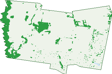
Green: 10 m cells where trees dominate, satellite 2021. Blue: water. The line is the suburb boundary.
| Canopy share, 1 m canopy height map, 2020 | 8.9% |
|---|---|
| Land with trees, 10 m satellite map, 2021 | 11.7% |
Demographics
Unemployment 6.8% · Labour-force participation 64.8%
Population by age in Harkness
| 0-4 | 1,243 |
|---|---|
| 5-14 | 2,348 |
| 15-19 | 778 |
| 20-24 | 794 |
| 25-34 | 2,054 |
| 35-44 | 2,144 |
| 45-54 | 1,398 |
| 55-64 | 862 |
| 65-74 | 599 |
| 75-84 | 223 |
| 85+ | 28 |
Dwelling types in Harkness
| House | 3,546 |
|---|---|
| Townhouse | 162 |
| Apartment | 64 |
| Other | 0 |
Households by weekly income in Harkness
| <$650 | 413 |
|---|---|
| $650-1,499 | 1,079 |
| $1,500-2,999 | 1,459 |
| $3,000+ | 576 |
Top ancestries in Harkness
| Australian | 3,435 |
|---|---|
| English | 3,019 |
| Other | 2,685 |
| Ancestry NS | 998 |
| Indian | 851 |
| Irish | 691 |
Housing tenure in Harkness
| Owned | 589 |
|---|---|
| Mortgage | 2,071 |
| Rented | 1,037 |
| Other | 16 |
Cars per household in Harkness
| 0 | 92 |
|---|---|
| 1 | 1,143 |
| 2 | 1,677 |
| 3 | 525 |
| 4+ | 285 |
Commute to work in Harkness
| Car | 3,674 |
|---|---|
| Train | 63 |
| Bus | 13 |
| Tram/ferry | 0 |
| Walked | 12 |
| Bicycle | 3 |
| Home | 783 |
Top countries of birth in Harkness
| India | 806 |
|---|---|
| New Zealand | 375 |
| Philippines | 300 |
| England | 179 |
| Malta | 145 |
| Samoa | 143 |
Languages used at home in Harkness
| Punjabi | 644 |
|---|---|
| Samoan | 215 |
| Hindi | 212 |
| Vietnamese | 155 |
| Tagalog | 148 |
| Arabic | 134 |
Birds & Wildlife Nearby
23,140 bird observations recorded near Harkness — most often seen:
- Little Raven (1,476)
- Australian Magpie (1,328)
- Red Wattlebird (1,270)
- Superb Fairy-wren (1,086)
- Eurasian Blackbird (1,032)
- White-plumed Honeyeater (908)
- Sulphur-crested Cockatoo (794)
- Magpie-lark (784)
- Willie Wagtail (780)
- Grey Fantail (779)
- New Holland Honeyeater (761)
- Crimson Rosella (713)
- Brown Thornbill (701)
Show all 30 birds recorded near Harkness
- Pacific Black Duck (683)
- Common Myna (673)
- Spotted Pardalote (655)
- Welcome Swallow (655)
- Eastern Rosella (653)
- Yellow-faced Honeyeater (651)
- White-winged Chough (645)
- Grey Shrike-thrush (632)
- Weebill (630)
- Grey Currawong (629)
- Australian Wood Duck (626)
- Crested Pigeon (622)
- Rainbow Lorikeet (619)
- Red-rumped Parrot (595)
- Silvereye (589)
- Galah (587)
- Buff-rumped Thornbill (584)
Sightings reported by observers, not a survey, so the counts show what people record rather than what lives here. Source: Atlas of Living Australia.
Nearby Suburbs
The closest suburbs to Harkness:
- Melton West (1.9 km)
- Kurunjang (2.8 km)
- Melton (3.3 km)
- Brookfield (3.9 km)
- Long Forest (4.4 km)
- Melton South (5 km)
- Hopetoun Park (6.3 km)
- Cobblebank (6.6 km)
Embed this suburb
Add this free Harkness stat card to your own site — just copy the code:
Preview:
Cite this page
Quoting these figures? Copy the credit line:
Keep an eye on Harkness
One email when this data meaningfully changes — new census figures, prices, rankings. No spam, unsubscribe anytime.
Streets
- Allambee Drive (22)
- Amelia Place (11)
- Andreas Court (16)
- Anouk Way (5)
- Arjun Avenue (20)
- Arnolds Creek Boulevard (71)
- Aruma Avenue (77)
- Ashton Circuit (11)
- Ashwood Grove (3)
- Ballamore Vista (2)
- Barker Lane (8)
- Bassenthwaite Vista (10)
- Bateman Drive (50)
- Bickley Street (12)
- Birch Lane (8)
- Biscay Court (6)
- Blossom Avenue (15)
- Borrowdale Road (41)
- Bradgate Lane (4)
- Brooksby Circuit (34)
- Bulmans Road (97)
- Buloke View (3)
- Burswood Circuit (35)
- Buttercup Rise (8)
- Butternut Street (14)
- Caitlyn Drive (84)
- Candlebark Place (6)
- Carramar Drive (44)
- Caruana Crescent (45)
- Casuarina Court (26)
- Centenary Avenue (54)
- Chanticleer Avenue (69)
- Charlotte Avenue (17)
- Cherry Close (14)
- Claret Ash Boulevard (115)
- Cobbler Street (13)
- Coburns Road (36)
- Colonial Way (16)
- Comic Court (15)
- Connata Place (5)
- Connolly Drive (24)
- Cooloongup Crescent (57)
- Cootamundra Circuit (29)
- Crepe Myrtle Close (12)
- Daisy Circuit (12)
- Dazln Drive (13)
- Dion Place (11)
- Drummond Court (5)
- Dulcify Court (10)
- Edgewood Drive (23)
- Eliana Close (7)
- Emerald Court (9)
- Erden Court (16)
- Featherhead Way (59)
- Ferdinand Place (16)
- Fiddlewood Turn (28)
- Field Avenue (17)
- Finlay Avenue (28)
- Fishburn Grove (60)
- Flemings Avenue (15)
- Galilee Boulevard (45)
- Gallery Avenue (66)
- Gamalite Drive (82)
- Gautam Grove (27)
- Giblin Lane (4)
- Golden Wattle Way (48)
- Gongurra Bowl (6)
- Granholm Grove (62)
- Grosvenor Court (14)
- Hadfield Road (24)
- Hardys Road (3)
- Harkness Road (67)
- Hawthorn Avenue (33)
- Hillcrest Court (25)
- Hobson Road (6)
- Holwell Lane (4)
- Howell Lane (4)
- Indigo Link (4)
- Janet Lane (12)
- Jolley Rise (15)
- Joseph Place (11)
- Josephine Court (9)
- Kalamunda Court (17)
- Karinya Way (22)
- Kate Avenue (2)
- Kim Lane (11)
- Koonawarra Terrace (22)
- Lady Penrhyn Drive (60)
- Lakeside Court (8)
- Lancers Drive (86)
- Lawrence Avenue (26)
- Leafy View Esplanade (28)
- Lewen Lane (3)
- Liapis Avenue (1)
- Lilac Court (13)
- Lister Road (15)
- Lomandra Bowl (53)
- Long Forest Avenue (83)
- Long Tree Drive (67)
- Louise Lane (1)
- Lucinda Mews (4)
- Makiti Bend (32)
- Makiti Crescent (34)
- Mandurah Crescent (49)
- Maple Close (14)
- Marlo Drive (68)
- Medina Court (14)
- Mercer Street (88)
- Merrystowe Way (46)
- Micasa Place (11)
- Miles Court (4)
- Minns Road (18)
- Mint Boulevard (41)
- Moor Park Avenue (36)
- Murnong Mews (24)
- Nicola Mews (3)
- Nodosa Grove (14)
- Noranda Circuit (55)
- Northgate Drive (23)
- Oakbank Court (8)
- Oakham Drive (15)
- Oakpark Drive (98)
- Orchid Avenue (25)
- Ormonde Esplanade (23)
- Pangbourne Avenue (43)
- Panorama Drive (37)
- Park Lane (17)
- Parkview Street (32)
- Parris Avenue (26)
- Petrea Place (42)
- Porteous Road (1)
- Portman Avenue (34)
- Postman Drive (2)
- Potter Lane (17)
- Princeton Avenue (36)
- Priscilla Court (15)
- Ravida Avenue (38)
- Rearsby Lane (3)
- Red Oak Street (5)
- Regent Place (10)
- Reidy Rise (42)
- Renate Drive (6)
- Rimfire Court (15)
- River Views Road (20)
- Riverbank Boulevard (28)
- Riverton Boulevard (24)
- Robinia Court (18)
- Rockingham Circuit (39)
- Rosedale Court (12)
- Rosemont Rise (18)
- Roslyn Park Drive (93)
- Royal Terrace (10)
- Satchville Road (11)
- Saunders Street (8)
- Scarborough Crescent (61)
- Scarlet Oak Avenue (38)
- Scenic Way (29)
- Shaheen Court (16)
- She Oak Court (8)
- Shearwater Way (10)
- Sinclair Court (14)
- Sovereign Boulevard (37)
- Spring Close (3)
- Stableford Chase (21)
- Stacey Court (20)
- Stefan Drive (21)
- Stephanie Way (17)
- Stilton Lane (4)
- Storkbill View (12)
- Sugar Berry Rise (16)
- Sullivan Place (14)
- Summer Court (8)
- Sunray Rise (16)
- Sunset Avenue (29)
- Susan Place (15)
- Terrington Place (5)
- The Crest (11)
- Themeda View (4)
- Todman Court (12)
- Torrance Drive (50)
- Trafford Lane (3)
- Trigg Street (6)
- Tristron Court (5)
- Tute Lane (10)
- Union Street (16)
- Valley View Grove (27)
- Vasaliki Court (14)
- Wallangara Boulevard (92)
- Wanneroo Circuit (46)
- Weeks Avenue (16)
- Whitegum Street (27)
- Willandra Boulevard (78)
- Willow Court (11)
- Woodland Rise (28)
- Wycombe Road (8)