Strathtulloh VIC 3338
4,649 addresses · 223 streets
Hawke Electorate › Melton LGA › Strathtulloh · 33 km from Melbourne
📦 Thinking of moving here? Read the Strathtulloh moving guide

Living Here
Strathtulloh is a suburb of Victoria, home to about 3,997 people, with a median age of 29. The typical household earns around $2,188 a week, with median rent near $380 a week. Most homes are houses. About 74% of households own their home and 26% rent. Most workers drive to work. Common community backgrounds include Australian, Indian, English. On the ABS socio-economic scale it sits in decile 8 of 10 nationally — a relatively advantaged area. The median house sells for about $629,000.
Getting Around & Local Services
15 schools
5 cafés & restaurants
2 supermarkets
1 pharmacy
2 doctors & medical clinics
1 dentist
1 hospital
3 childcare & kindergartens
1 library
5 service stations
3 gyms & sports centres
2 golf clubs
2 bakeries
2 hardware stores
2 hairdressers
2 beauty salons
1 mechanic
Getting around. Train station: Cobblebank, 1.6 km north · Bus interchange: Temporary Melton Station bus interchange, 3.5 km north-west · Airport: Melbourne Airport, 21.3 km east.
Sport & Recreation
1 facility recorded in Strathtulloh.
- Bridge Road Sports Precinct Athletics, Hockey
Socio-economic Standing
Deciles from 1 (lowest) to 10 (highest), against all Australian suburbs. The overall figure weighs advantage and disadvantage together; economic resources counts income and housing, and education & jobs counts qualifications and occupation. They often differ. Source: ABS SEIFA 2021.
Median Sale Prices
Median of recorded sales in the period, not a valuation. Source: Victorian Property Sales Report, Land Use Victoria.
Tree cover
🌳 Tree canopy: 3.1% share of land under canopy · satellite map, 2020
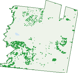
Green: 10 m cells where trees dominate, satellite 2021. Blue: water. The line is the suburb boundary.
| Canopy share, 1 m canopy height map, 2020 | 3.1% |
|---|---|
| Land with trees, 10 m satellite map, 2021 | 10.1% |
Demographics
Unemployment 5.1% · Labour-force participation 75.1%
Population by age in Strathtulloh
| 0-4 | 551 |
|---|---|
| 5-14 | 624 |
| 15-19 | 127 |
| 20-24 | 265 |
| 25-34 | 1,091 |
| 35-44 | 807 |
| 45-54 | 254 |
| 55-64 | 176 |
| 65-74 | 77 |
| 75-84 | 25 |
| 85+ | 7 |
Dwelling types in Strathtulloh
| House | 1,156 |
|---|---|
| Townhouse | 24 |
| Apartment | 0 |
| Other | 0 |
Households by weekly income in Strathtulloh
| <$650 | 59 |
|---|---|
| $650-1,499 | 240 |
| $1,500-2,999 | 539 |
| $3,000+ | 275 |
Top ancestries in Strathtulloh
| Other | 1,351 |
|---|---|
| Australian | 686 |
| Indian | 622 |
| English | 606 |
| Filipino | 384 |
| Ancestry NS | 272 |
Housing tenure in Strathtulloh
| Owned | 91 |
|---|---|
| Mortgage | 772 |
| Rented | 306 |
| Other | 3 |
Cars per household in Strathtulloh
| 0 | 25 |
|---|---|
| 1 | 363 |
| 2 | 582 |
| 3 | 148 |
| 4+ | 63 |
Commute to work in Strathtulloh
| Car | 1,243 |
|---|---|
| Train | 66 |
| Bus | 0 |
| Tram/ferry | 0 |
| Walked | 13 |
| Bicycle | 3 |
| Home | 419 |
Top countries of birth in Strathtulloh
| India | 841 |
|---|---|
| Philippines | 306 |
| New Zealand | 123 |
| Bangladesh | 41 |
| Pakistan | 39 |
| Malta | 28 |
Languages used at home in Strathtulloh
| Punjabi | 816 |
|---|---|
| Tagalog | 142 |
| Filipino | 125 |
| Hindi | 112 |
| Tamil | 60 |
| Bengali | 55 |
Birds & Wildlife Nearby
22,424 bird observations recorded near Strathtulloh — most often seen:
- Little Raven (1,279)
- Australian Magpie (1,160)
- Common Starling (1,148)
- Willie Wagtail (1,104)
- White-plumed Honeyeater (1,099)
- House Sparrow (1,075)
- Common Myna (991)
- Magpie-lark (956)
- Red-rumped Parrot (956)
- Pacific Black Duck (897)
- Australian Wood Duck (838)
- Red Wattlebird (801)
- Eastern Rosella (798)
Show all 30 birds recorded near Strathtulloh
- Welcome Swallow (772)
- Crested Pigeon (742)
- Superb Fairy-wren (720)
- Galah (697)
- Eurasian Blackbird (618)
- Rainbow Lorikeet (612)
- Noisy Miner (565)
- Eurasian Coot (532)
- New Holland Honeyeater (515)
- Yellow-rumped Thornbill (504)
- White-faced Heron (478)
- Long-billed Corella (455)
- Australasian Purple Swamphen (445)
- Masked Lapwing (443)
- Brown Falcon (426)
- Chestnut Teal (403)
- Straw-necked Ibis (395)
Sightings reported by observers, not a survey, so the counts show what people record rather than what lives here. Source: Atlas of Living Australia.
Nearby Suburbs
The closest suburbs to Strathtulloh:
- Cobblebank (1.4 km)
- Weir Views (2.6 km)
- Thornhill Park (2.6 km)
- Melton South (3.2 km)
- Grangefields (4.4 km)
- Melton (4.8 km)
- Rockbank (4.9 km)
- Fieldstone (5.1 km)
Embed this suburb
Add this free Strathtulloh stat card to your own site — just copy the code:
Preview:
Cite this page
Quoting these figures? Copy the credit line:
Keep an eye on Strathtulloh
One email when this data meaningfully changes — new census figures, prices, rankings. No spam, unsubscribe anytime.
Streets
- Acanea Street (29)
- Adagio Road (23)
- Alfred Road (42)
- Alkington Street (23)
- Allegro Street (5)
- Ambien Crescent (39)
- Amity Street (3)
- Anker Place (5)
- Annabell Close (4)
- Antrim Walk (11)
- Arena Circuit (44)
- Astley Drive (36)
- Atherstone Boulevard (123)
- Augusta Way (20)
- Azadi Crescent (37)
- Baddesley Circuit (12)
- Ballad Street (21)
- Ballart Drive (5)
- Ballymena Street (23)
- Baritone Road (4)
- Basildon Crescent (54)
- Beadnell Place (14)
- Becontree Crescent (50)
- Belconnen Avenue (19)
- Bellerive Crescent (27)
- Bellingham Road (12)
- Belper Place (4)
- Belston Avenue (4)
- Bernabau Avenue (10)
- Bluebrush Way (10)
- Borda Close (3)
- Bracknell Crescent (23)
- Brasilia Street (14)
- Bridge Road (25)
- Bristol Street (33)
- Buckingham Boulevard (95)
- Burnage Place (10)
- Calderwood Walk (10)
- Carisbrook Place (4)
- Carrick Avenue (21)
- Castlecrag Way (65)
- Centralpark Lane (13)
- Centralpark Walk (13)
- Cherington Place (14)
- Chiswick Crescent (14)
- Chorley Street (21)
- Clef Street (15)
- Clematis Place (5)
- Colosseum Drive (19)
- Columbia Avenue (14)
- Corby Way (7)
- Cranbrook Street (26)
- Craven Way (11)
- Crawley Street (20)
- Crested Way (10)
- Creswell Place (6)
- Cromford Drive (13)
- Curitiba Way (9)
- Dacey Place (3)
- Denham Place (4)
- Dickens Street (34)
- Dormer Street (5)
- Downley Loop (17)
- Drumchapel Crescent (39)
- Drumcondra Avenue (7)
- Duke Drive (46)
- Eaglemont Drive (71)
- Ebbsfleet Crescent (24)
- Edgemead Street (7)
- Elland Street (14)
- Euston Way (4)
- Everlasting Boulevard (91)
- Fairholme Crescent (14)
- Fenway Street (24)
- Ferrars Place (2)
- Ferris Road (20)
- Folsom Place (2)
- Forestmill Way (12)
- Fratton Avenue (10)
- Galgota Circuit (42)
- Gamesley Street (12)
- Garrard Court (5)
- Gidea Place (4)
- Glenard Avenue (30)
- Glenrothes Street (11)
- Gramercy Place (28)
- Grappenhall Avenue (81)
- Greens Road (19)
- Greigs Road (1)
- Greigs Road W (1)
- Grey Box Drive (9)
- Gulab Street (5)
- Halford Way (16)
- Hamlet Place (4)
- Hardwick Road (22)
- Harlow Drive (7)
- Hatfield Street (24)
- Hattersley Street (14)
- Hatton Place (13)
- Headingley Grove (16)
- Hemel Place (4)
- Hertford Place (12)
- Highgarden Road (21)
- Hydepark Crescent (30)
- Innage Avenue (26)
- Ipswich Street (8)
- Irvine Avenue (37)
- Jasud Way (1)
- Jesmond Road (8)
- Joondalup Street (8)
- Juliete Street (38)
- Keighley Street (15)
- Kevda Street (2)
- Keynes Place (5)
- Killester Walk (11)
- Knebworth Drive (31)
- Ladbroke Street (16)
- Lath Place (4)
- Leeton Street (21)
- Leopold Street (29)
- Letchworth Street (18)
- Little Raven Road (20)
- Lodge Walk (12)
- Lords Way (7)
- Lydford Street (16)
- Maracana Circuit (43)
- Maruns Place (2)
- Marylebone Street (14)
- Menon Path (6)
- Milton Place (5)
- Mistletoe Drive (33)
- Monaco Grove (20)
- Morpeth Way (1)
- Mount Cottrell Road (13)
- Murrayfield Place (4)
- Neyland Street (16)
- Nicholson Court (6)
- Northstowe Crescent (42)
- Octavia Place (11)
- Odsal Walk (17)
- Okehampton Street (6)
- Olympic Circuit (23)
- Opus Road (26)
- Opus Street (29)
- Overture Road (23)
- Palara Drive (39)
- Perons Road (16)
- Pickwick Avenue (4)
- Pipit Street (20)
- Pollock Drive (18)
- Pollok Drive (18)
- Poundbury Avenue (15)
- Prenton Avenue (30)
- Presto Road (19)
- Pulteney Drive (29)
- Ranelagh Avenue (27)
- Ravenscraig Drive (51)
- Redditch Street (9)
- Redgum Drive (5)
- Renaissance Drive (34)
- Reston Way (24)
- Rice Flower Crescent (55)
- Ridditch Street (1)
- Roehampton Drive (52)
- Ruislip Avenue (37)
- Ruislip Crescent (35)
- Runcorn Crescent (53)
- Rushton Avenue (16)
- Saddlebunch Place (13)
- Saltaire Drive (54)
- Sandringham Street (26)
- Sandygate Circuit (35)
- Sanford Close (6)
- Saputo Place (2)
- Selbourne Street (65)
- Shawfair Place (5)
- Shelduck Street (1)
- Sicklefern Drive (24)
- Sigsbee Place (4)
- Snipe Drive (34)
- Southlands Loop (35)
- Spadefoot Place (15)
- Staccato Terrace (20)
- Stevenage Drive (40)
- Strathtulloh Circuit (58)
- Swaney Court (5)
- Swanpool Place (4)
- Sweet Way (8)
- Telford Place (3)
- Templetonia Drive (22)
- Tenor Street (23)
- Thatcher Way (20)
- Topsham Road (22)
- Tornagrain Circuit (7)
- Totterdown Street (18)
- Trafalgar Road (25)
- Trafalgar Street (31)
- Travistock Street (6)
- Trookfield Street (12)
- Truman Drive (34)
- Twickenham Walk (6)
- Unison Circuit (51)
- Unison Road (73)
- Valley Road (2)
- Vanilla Way (10)
- Veltins Way (20)
- Waldorf Avenue (14)
- Watton Street (4)
- Wedge-tailed Court (6)
- Welwyn Grove (18)
- Wembley Avenue (119)
- Wembley Street (3)
- Wembly Avenue (1)
- Westbourne Street (41)
- Westfalen Place (2)
- Widecombe Way (22)
- Wimbledom Boulevard (23)
- Wimbledon Avenue (23)
- Wimbledon Boulevard (75)
- Winchester Drive (34)
- Witherley Avenue (10)
- Woden Place (3)
- Yallourn Place (5)