Lilydale VIC 3140
10,625 addresses · 380 streets
Casey Electorate › Yarra Ranges LGA › Lilydale · 35 km from Melbourne
📦 Thinking of moving here? Read the Lilydale moving guide

Living Here
An outer-eastern Melbourne town at the gateway to the Yarra Valley, Lilydale blends a township feel with commuter convenience. Households average 2.5 people and the median age is 40. Median household income is $1,764 a week, with rent around $369.
Lilydale is a suburb of Victoria, home to about 17,348 people, with a median age of 40. The typical household earns around $1,764 a week, with median rent near $369 a week. Most homes are houses. About 78% of households own their home and 19% rent. Most workers drive to work. Common community backgrounds include English, Australian, Scottish. On the ABS socio-economic scale it sits in decile 7 of 10 nationally — a mid-range area. The median house sells for about $865,000.
Over time — Census 2001 → 2021
Dashed line: district figures for the Lilydale - Coldstream statistical area (SA2), the smallest area the ABS published before 2011. Solid line: Lilydale itself.
Getting Around & Local Services
3 supermarkets
3 Catholic churches
3 doctors & medical clinics
2 dentists
2 physiotherapists
4 optometrists
1 post office
2 playgrounds
1 dog park
1 butcher
4 hairdressers
2 plumbers
1 carpenter
Getting around. Train station: Lilydale, 700 m west · Bus interchange: Lilydale High School Bus Terminus, 850 m south-west · Airport: Moorabbin Airport, 33.2 km south-west.
Sport & Recreation
5 facilities recorded in Lilydale.
- Curves Lilydale Fitness / Gymnasium Workouts
- Lilydale BMX Club BMX
- Lilydale Bowls and Tennis Club Lawn Bowls, Motor Sports, Tennis (Outdoor)
- Lilydale Recreation Reserve Australian Rules Football, Cricket, Swimming
- Mt Lilydale Sports Ovals Australian Rules Football, Cricket, Soccer
Socio-economic Standing
Deciles from 1 (lowest) to 10 (highest), against all Australian suburbs. The overall figure weighs advantage and disadvantage together; economic resources counts income and housing, and education & jobs counts qualifications and occupation. They often differ. Source: ABS SEIFA 2021.
Median Sale Prices
Median of recorded sales in the period, not a valuation. Source: Victorian Property Sales Report, Land Use Victoria.
Tree cover
🌳 Tree canopy: 30% share of land under canopy · satellite map, 2020
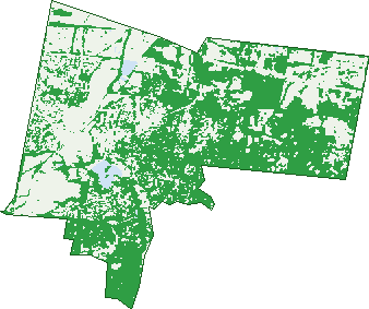
Green: 10 m cells where trees dominate, satellite 2021. Blue: water. The line is the suburb boundary.
| Canopy share, 1 m canopy height map, 2020 | 30.0% |
|---|---|
| Land with trees, 10 m satellite map, 2021 | 55.0% |
Demographics
Unemployment 3.4% · Labour-force participation 64.6%
Population by age in Lilydale
| 0-4 | 967 |
|---|---|
| 5-14 | 2,011 |
| 15-19 | 1,077 |
| 20-24 | 1,065 |
| 25-34 | 2,302 |
| 35-44 | 2,132 |
| 45-54 | 2,405 |
| 55-64 | 2,194 |
| 65-74 | 1,708 |
| 75-84 | 1,068 |
| 85+ | 425 |
Dwelling types in Lilydale
| House | 5,221 |
|---|---|
| Townhouse | 1,240 |
| Apartment | 9 |
| Other | 61 |
Households by weekly income in Lilydale
| <$650 | 989 |
|---|---|
| $650-1,499 | 1,714 |
| $1,500-2,999 | 2,061 |
| $3,000+ | 1,380 |
Top ancestries in Lilydale
| English | 7,527 |
|---|---|
| Australian | 6,763 |
| Scottish | 1,828 |
| Irish | 1,770 |
| Italian | 1,253 |
| Other | 1,242 |
Housing tenure in Lilydale
| Owned | 2,169 |
|---|---|
| Mortgage | 2,916 |
| Rented | 1,242 |
| Other | 153 |
Cars per household in Lilydale
| 0 | 290 |
|---|---|
| 1 | 2,073 |
| 2 | 2,581 |
| 3 | 901 |
| 4+ | 648 |
Commute to work in Lilydale
| Car | 5,326 |
|---|---|
| Train | 106 |
| Bus | 36 |
| Tram/ferry | 0 |
| Walked | 81 |
| Bicycle | 13 |
| Home | 1,918 |
Top countries of birth in Lilydale
| England | 875 |
|---|---|
| New Zealand | 204 |
| India | 176 |
| Italy | 176 |
| Netherlands | 144 |
| South Africa | 133 |
Languages used at home in Lilydale
| Italian | 245 |
|---|---|
| Mandarin | 90 |
| Spanish | 72 |
| Hindi | 58 |
| Sinhalese | 52 |
| Cantonese | 47 |
Birds & Wildlife Nearby
62,151 bird observations recorded near Lilydale — most often seen:
- Little Raven (2,922)
- Common Myna (2,785)
- Noisy Miner (2,729)
- Pacific Black Duck (2,578)
- Australian Wood Duck (2,546)
- Magpie-lark (2,531)
- Australasian Purple Swamphen (2,529)
- Eurasian Coot (2,523)
- Eurasian Blackbird (2,358)
- Welcome Swallow (2,291)
- Australian Magpie (2,268)
- Common Starling (2,261)
- Rainbow Lorikeet (2,227)
Show all 30 birds recorded near Lilydale
- Dusky Moorhen (2,039)
- Red Wattlebird (2,016)
- Australian White Ibis (2,010)
- Grey Butcherbird (1,977)
- Spotted Turtle-dove (1,945)
- Eastern Rosella (1,927)
- Superb Fairy-wren (1,854)
- Galah (1,847)
- White-faced Heron (1,737)
- Sulphur-crested Cockatoo (1,726)
- Grey Teal (1,631)
- Southern Victoria Australian Magpie (1,597)
- Brown Thornbill (1,589)
- Little Pied Cormorant (1,446)
- Chestnut Teal (1,444)
- Crested Pigeon (1,425)
- Masked Lapwing (1,393)
Sightings reported by observers, not a survey, so the counts show what people record rather than what lives here. Source: Atlas of Living Australia.
Nearby Suburbs
The closest suburbs to Lilydale:
- Chirnside Park (3.3 km)
- Mooroolbark (3.8 km)
- Mount Evelyn (4 km)
- Coldstream (4.9 km)
- Montrose (6.1 km)
- Kilsyth (6.2 km)
- Croydon North (6.3 km)
- Wandin North (6.8 km)
Embed this suburb
Add this free Lilydale stat card to your own site — just copy the code:
Preview:
Cite this page
Quoting these figures? Copy the credit line:
Keep an eye on Lilydale
One email when this data meaningfully changes — new census figures, prices, rankings. No spam, unsubscribe anytime.
Streets
- Abbie Close (4)
- Aberdeen Drive (18)
- Achilles Court (17)
- Admiral Court (19)
- Ajax Court (12)
- Alanah Close (7)
- Albert Hill Road (119)
- Albert Road (58)
- Alexandra Road (103)
- Alfred Road (26)
- Allenby Road (25)
- Allison Crescent (15)
- Altair Court (12)
- Anderson Street (199)
- Andy Close (12)
- Angus Place (6)
- Anne Street (5)
- Annie Way (5)
- Aquarius Court (11)
- Archer Close (20)
- Arna Mews (17)
- Arwon Court (33)
- Assunta Place (7)
- Athlone Street (13)
- Badger Court (15)
- Baker Street (46)
- Banker Court (12)
- Barnsley Close (6)
- Bastow Road (121)
- Baystone Place (21)
- Beaulieu Avenue (31)
- Bella Vista Way (24)
- Bellbird Drive (47)
- Belle Vue (22)
- Benito Court (28)
- Beresford Road (262)
- Berry Court (10)
- Berwick Street (20)
- Bionda Court (4)
- Bitalli Court (3)
- Black Street (14)
- Blair Street (68)
- Bligh Court (17)
- Bolger Walk (17)
- Boundary Road (13)
- Bounty Court (17)
- Bowen Road (38)
- Bramwell Street (33)
- Bravo Court (14)
- Brew Court (7)
- Brightwell Road (11)
- Bristol Crescent (55)
- Britannia Way (65)
- Brock Industrial Drive (18)
- Brown Street (37)
- Burton Road (10)
- Bushland Grove (2)
- Camplin Rise (16)
- Candlebark Circuit (17)
- Carmen Court (22)
- Cashins Mill Place (18)
- Castella Street (160)
- Cave Hill Road (283)
- Century Mews (4)
- Chapel Street (27)
- Charles Road (79)
- Charlie Close (8)
- Chelsworth Park Lane (26)
- Chester Street (66)
- Chiefly Close (12)
- Chris Drive (32)
- Christa Court (11)
- Clarke Street (129)
- Clearwater Drive (45)
- Clifton Place (7)
- Closter Court (6)
- Clyde Street (57)
- Cobden Crescent (27)
- Comic Court (11)
- Community Way (22)
- Como Road (18)
- Conlan Way (15)
- Coozac Close (10)
- Coozac Place (10)
- Coral Close (8)
- Cosy Place (20)
- Cowles Crescent (21)
- Creek Road (9)
- Crestway (24)
- Crombie Road (8)
- Cunningham Road (35)
- Cyril Street (5)
- Dahlia Close (8)
- Daisy Place (5)
- Dalray Place (20)
- Daniels Street (13)
- David Road (86)
- Delta Close (19)
- Deschamps Avenue (12)
- Deschamps Street (104)
- Diggers Walk (6)
- Dixon Place (10)
- Don Court (12)
- Doonside Drive (18)
- Dover Close (6)
- Drake Court (4)
- Driller Place (8)
- Duffity Place (7)
- Dylan Close (6)
- Earlswood Place (47)
- East Court (31)
- Ebony Close (7)
- Edinburgh Road (68)
- Eelam Place (4)
- Elevation Close (12)
- Eliza Mews (9)
- Elsiano Terrace (8)
- Erdogan Place (10)
- Erldunda Court (21)
- Eucalypt Drive (78)
- Evie Close (6)
- Fairview Close (6)
- Fanning Close (5)
- Flanagan Crescent (14)
- Fortune Avenue (29)
- Gallagher Crescent (21)
- Gallivan Circuit (29)
- Gardiner Street (31)
- Gary Court (12)
- George Street (19)
- Gilba Place (3)
- Gladstone Street (63)
- Glencoe Place (23)
- Glenloth Avenue (17)
- Glenside Close (7)
- Goodall Drive (21)
- Grand View Grove (25)
- Greenlees Court (7)
- Grosvenor Walk (29)
- Hampton Court (18)
- Hardy Street (25)
- Haricot Way (23)
- Harmony Close (20)
- Helena Road (19)
- Herb Farm Lane (18)
- Hereford Road (66)
- Heritage Drive (34)
- Hermitage Street (29)
- Hightech Place (46)
- Hillcrest Place (3)
- Hillside Court (17)
- Holly Place (9)
- Homestead Place (10)
- Honour Avenue (29)
- Horatio Court (16)
- Hull Road (44)
- Hutchinson Street (103)
- Hyne Street (24)
- Industrial Park Drive (74)
- Industry Court (47)
- Ingram Road (8)
- Isla Close (6)
- Jacks Place (4)
- Jaipril Place (8)
- Janson Place (24)
- Jarlo Drive (3)
- Jarlo Road (3)
- Jayde Close (6)
- Jennifer Road (5)
- Jessica Park Drive (14)
- John Street (117)
- Jones Street (21)
- Josie Court (7)
- Joy Court (10)
- Jurat Road (7)
- Karabec Place (12)
- Karita Court (3)
- Kenisha Way (6)
- Kenthurst Court (29)
- Kerr Street (54)
- Kidgell Street (102)
- Kingsburgh Lane (73)
- Koombooloomba Court (19)
- Kuro Place (7)
- Kyra Close (17)
- Lacey Close (3)
- Lakers Place (4)
- Lakeside Village Drive (13)
- Lakeview Drive (152)
- Lantern Place (9)
- Lauren Court (9)
- Lawrence Close (3)
- Leaves Close (8)
- Leigh Close (4)
- Leonard Road (14)
- Libra Close (9)
- Lilac Rise (16)
- Lily Road (17)
- Longtown Close (17)
- Lucille Close (6)
- Ludlow Crescent (8)
- Maggie Place (8)
- Main Street (271)
- Maison Close (5)
- Mandl Close (14)
- Mangans Road (70)
- Marana Close (23)
- Maria Close (10)
- Market Street (18)
- Maroondah Court (12)
- Maroondah Highway (596)
- Marven Court (8)
- Matden Place (6)
- Mattea Court (13)
- Mccomb Street (118)
- Mcneil Avenue (4)
- Meadowvale Court (15)
- Megan Place (6)
- Melba Avenue (27)
- Melody Close (23)
- Menindee Court (7)
- Mentor Grove (19)
- Messmate Place (7)
- Mitchell Road (53)
- Mont Vue (31)
- Monza Court (8)
- Mooroolbark Road (1)
- Morecroft Place (2)
- Morna Street (12)
- Mornane Close (7)
- Morokai Grove (63)
- Munro Avenue (6)
- Nelson Road (181)
- Neptune Court (9)
- Newhaven Court (19)
- Nicholas Street (70)
- Nicholson Crescent (11)
- Nicholson Lane (6)
- Nimblefoot Way (86)
- Noble Court (11)
- Norris Drive (25)
- North Road (89)
- Oakleaf Place (13)
- Oaks Street (20)
- Odell Court (10)
- Old Gippsland Road (121)
- Olinda Park Rise (16)
- Olive Grove (14)
- Opal Court (9)
- Orion Court (11)
- Osullivans Road (6)
- Otterington Way (21)
- Ozark Mews (5)
- Pablo Place (7)
- Pancha Close (3)
- Panorama Rise (17)
- Pardella Way (3)
- Park Lane (24)
- Parker Drive (31)
- Parkside Close (38)
- Patel Close (6)
- Penny Lane (9)
- Phillip Close (9)
- Pine Street (19)
- Pinnacle Rise (18)
- Pisces Court (8)
- Plaza Court (28)
- Potters Rise (3)
- Poyner Avenue (28)
- Pride Lane (11)
- Prudence Court (15)
- Quarry Road (5)
- Queen Road (54)
- Raffaele Close (6)
- Rainbird Crescent (42)
- Ramada Court (7)
- Raymond Close (4)
- Rebecca Court (3)
- Redmill Court (10)
- Reece Court (12)
- Revenue Place (13)
- Rimfire Court (21)
- Roach Road (10)
- Rockys Way (39)
- Roeschinger Way (6)
- Rolaine Close (19)
- Rory Court (15)
- Rose Court (15)
- Rosedale Close (5)
- Rosemont Road (3)
- Rotherwood Place (6)
- Rouke Street (100)
- Rudyard Court (8)
- Rundel Close (8)
- Russia Mews (10)
- Rye Close (5)
- Ryrie Court (11)
- Saintly Place (5)
- Salisbury Bend (29)
- Sanctuary Court (9)