Chirnside Park VIC 3116
5,431 addresses · 206 streets
Casey Electorate › Yarra Ranges LGA › Chirnside Park · 32 km from Melbourne
📦 Thinking of moving here? Read the Chirnside Park moving guide

Living Here
Chirnside Park is a suburb of Victoria, home to about 11,779 people, with a median age of 38. The typical household earns around $2,084 a week, with median rent near $443 a week. Most homes are houses. About 84% of households own their home and 15% rent. Most workers drive to work. Common community backgrounds include English, Australian, Irish. On the ABS socio-economic scale it sits in decile 8 of 10 nationally — a relatively advantaged area. The median house sells for about $890,500.
Over time — Census 2001 → 2021
Dashed line: district figures for the Chirnside Park statistical area (SA2), the smallest area the ABS published before 2011. Solid line: Chirnside Park itself.
Getting Around & Local Services
6 supermarkets
3 doctors & medical clinics
1 physiotherapist
3 childcare & kindergartens
2 libraries
2 post offices
8 service stations
1 dog park
1 carpenter
2 places to stay
Getting around. Train station: Lilydale, 2.6 km east · Bus interchange: Lilydale High School Bus Terminus, 2.7 km east · Airport: Moorabbin Airport, 31.7 km south-west.
Sport & Recreation
4 facilities recorded in Chirnside Park.
- Chirnside Park Country Club Golf, Lawn Bowls, Tennis (Outdoor)
- Female Gym Chirnside Park Fitness / Gymnasium Workouts
- Fit Chirnside park Fitness / Gymnasium Workouts
- Kimberley Reserve Australian Rules Football, Cricket
Socio-economic Standing
Deciles from 1 (lowest) to 10 (highest), against all Australian suburbs. The overall figure weighs advantage and disadvantage together; economic resources counts income and housing, and education & jobs counts qualifications and occupation. They often differ. Source: ABS SEIFA 2021.
Median Sale Prices
Median of recorded sales in the period, not a valuation. Source: Victorian Property Sales Report, Land Use Victoria.
Tree cover
🌳 Tree canopy: 6.2% share of land under canopy · satellite map, 2020
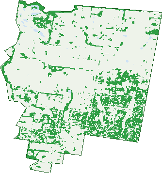
Green: 10 m cells where trees dominate, satellite 2021. Blue: water. The line is the suburb boundary.
| Canopy share, 1 m canopy height map, 2020 | 6.2% |
|---|---|
| Land with trees, 10 m satellite map, 2021 | 21.8% |
Demographics
Unemployment 3.1% · Labour-force participation 66.8%
Population by age in Chirnside Park
| 0-4 | 805 |
|---|---|
| 5-14 | 1,502 |
| 15-19 | 725 |
| 20-24 | 694 |
| 25-34 | 1,536 |
| 35-44 | 1,629 |
| 45-54 | 1,502 |
| 55-64 | 1,362 |
| 65-74 | 1,174 |
| 75-84 | 691 |
| 85+ | 165 |
Dwelling types in Chirnside Park
| House | 3,987 |
|---|---|
| Townhouse | 65 |
| Apartment | 17 |
| Other | 0 |
Households by weekly income in Chirnside Park
| <$650 | 494 |
|---|---|
| $650-1,499 | 909 |
| $1,500-2,999 | 1,319 |
| $3,000+ | 1,086 |
Top ancestries in Chirnside Park
| English | 4,643 |
|---|---|
| Australian | 4,243 |
| Irish | 1,127 |
| Scottish | 1,107 |
| Other | 979 |
| Italian | 850 |
Housing tenure in Chirnside Park
| Owned | 1,486 |
|---|---|
| Mortgage | 1,911 |
| Rented | 605 |
| Other | 34 |
Cars per household in Chirnside Park
| 0 | 92 |
|---|---|
| 1 | 1,051 |
| 2 | 1,863 |
| 3 | 630 |
| 4+ | 406 |
Commute to work in Chirnside Park
| Car | 3,626 |
|---|---|
| Train | 45 |
| Bus | 23 |
| Tram/ferry | 0 |
| Walked | 44 |
| Bicycle | 6 |
| Home | 1,367 |
Top countries of birth in Chirnside Park
| England | 482 |
|---|---|
| China | 236 |
| India | 198 |
| Italy | 161 |
| New Zealand | 125 |
| South Africa | 84 |
Languages used at home in Chirnside Park
| Mandarin | 298 |
|---|---|
| Italian | 185 |
| Cantonese | 88 |
| Punjabi | 76 |
| Persian | 65 |
| Hindi | 61 |
Birds & Wildlife Nearby
68,841 bird observations recorded near Chirnside Park — most often seen:
- Pacific Black Duck (3,177)
- Common Myna (3,116)
- Little Raven (3,102)
- Australasian Purple Swamphen (3,091)
- Australian Wood Duck (3,047)
- Noisy Miner (3,011)
- Eurasian Coot (2,915)
- Magpie-lark (2,735)
- Australian Magpie (2,638)
- Dusky Moorhen (2,527)
- Rainbow Lorikeet (2,467)
- Welcome Swallow (2,378)
- Eurasian Blackbird (2,360)
Show all 30 birds recorded near Chirnside Park
- Red Wattlebird (2,260)
- Australian White Ibis (2,219)
- Common Starling (2,127)
- Spotted Turtle-dove (2,105)
- Grey Butcherbird (2,086)
- Galah (2,028)
- Superb Fairy-wren (2,006)
- Eastern Rosella (1,997)
- White-faced Heron (1,986)
- Grey Teal (1,865)
- Sulphur-crested Cockatoo (1,864)
- Brown Thornbill (1,792)
- Little Pied Cormorant (1,653)
- Chestnut Teal (1,608)
- Southern Victoria Australian Magpie (1,597)
- Masked Lapwing (1,546)
- Grey Fantail (1,538)
Sightings reported by observers, not a survey, so the counts show what people record rather than what lives here. Source: Atlas of Living Australia.
Nearby Suburbs
The closest suburbs to Chirnside Park:
- Mooroolbark (3.2 km)
- Lilydale (3.3 km)
- Croydon North (3.6 km)
- Wonga Park (3.7 km)
- Croydon Hills (5.1 km)
- Croydon (5.5 km)
- Kilsyth (6 km)
- Bend Of Islands (6.3 km)
Embed this suburb
Add this free Chirnside Park stat card to your own site — just copy the code:
Preview:
Cite this page
Quoting these figures? Copy the credit line:
Keep an eye on Chirnside Park
One email when this data meaningfully changes — new census figures, prices, rankings. No spam, unsubscribe anytime.
Streets
- Akarana Road (12)
- Alderley Court (5)
- Allambi Road (15)
- Ally Terrace (17)
- Amadeo Way (81)
- Anthony Drive (75)
- Arthur Road (3)
- Avon Place (6)
- Bardaster Boulevard (42)
- Beaumont Drive (21)
- Belmike Close (7)
- Belsay Chase (55)
- Berkley Place (5)
- Billanook Way (96)
- Black Springs Road (44)
- Blackfriars Lane (19)
- Bonavita Court (19)
- Botanica Drive (110)
- Bower Walk (7)
- Brambleberry Lane (13)
- Breakaday Pass (14)
- Bridle Path (13)
- Bromley Close (9)
- Buggyride Lane (8)
- Buvelot Court (13)
- Buxton Street (14)
- Caddie Crescent (11)
- Camden Drive (46)
- Campus Gate (16)
- Carmella Close (21)
- Carnoustie Crescent (10)
- Carnoustie Lane (5)
- Carole Avenue (41)
- Carrington Court (9)
- Castle Way (5)
- Celeste Court (23)
- Champagne Rise (23)
- Chardonnay Grove (8)
- Chatswood Grove (28)
- Chequers Court (7)
- Cherry Hill Way (17)
- Chippendale Court (12)
- Chirnside Drive (90)
- Circle Ridge (61)
- Clinton Lane (15)
- Cloverdale Lane (8)
- Clubpoint Drive (55)
- Coachmans Court (20)
- Coldstream West Road (5)
- Columbia Boulevard (45)
- Commerford Place (19)
- Contour Court (11)
- Cotswold Court (6)
- Country Club Drive (101)
- Coventry Place (8)
- Craig Court (3)
- Crown Point (30)
- Crown Point Ridge (50)
- Cullen Court (9)
- Cumberland Crescent (26)
- Cypress Court (4)
- Delamere Drive (18)
- Domaine Grove (13)
- Drovers Walk (12)
- East Link (8)
- East Ridge Drive (27)
- Edgar Close (9)
- Edward Road (157)
- El Centro (24)
- Elfin Court (7)
- Eustace Close (17)
- Eyton Close (8)
- Family Place (5)
- Fletcher Road (20)
- Footman Mews (6)
- Glendale Drive (28)
- Goldentree Drive (29)
- Goodwin Street (12)
- Grandvalley Drive (45)
- Greenridge Court (10)
- Gretel Pass (5)
- Greythorn Court (6)
- Gully Mews (4)
- Haldane Close (14)
- Harvest Drive (46)
- Hayride Lane (19)
- Hedwig Drive (1)
- Henley Bridge Road (18)
- Heritage Avenue (107)
- Hewes Avenue (7)
- Hillrise Crescent (17)
- Hollyoak Haven (5)
- Honeysuckle Way (17)
- Hughes Road (2)
- Huntingdale Drive (76)
- Joanne Avenue (48)
- Karrala Court (13)
- Kentish Place (6)
- Kimberley Drive (59)
- Kingswood Drive (74)
- Knight Way (4)
- Lancaster Place (25)
- Lancer Way (8)
- Leahe Way (5)
- Little Chipping Drive (20)
- Locksley Road (63)
- Lukes Close (5)
- Manchester Road (4)
- Mansion Place (6)
- Margaret Avenue (7)
- Maroondah Highway (312)
- Mayfair Court (18)
- Meadow Fair Way (17)
- Meadowbank Avenue (27)
- Meadowgate Drive (99)
- Melba Place (5)
- Melrose Way (7)
- Morton Place (7)
- Muirfield Mews (14)
- Nellie Court (21)
- Nicklaus Place (13)
- North Link (4)
- Norwich Close (10)
- Oak Court (17)
- Old Melbourne Road (16)
- Old Mill Place (8)
- Outlook Drive (53)
- Oxley Court (5)
- Parkla Brae (7)
- Parklands Avenue (23)
- Parkvalley Drive (76)
- Parkview Terrace (22)
- Paula Way (39)
- Paynes Road (11)
- Peden Street (29)
- Pinehurst Place (17)
- Polaris Way (24)
- Porter Mews (4)
- Ramset Drive (10)
- Ranger Close (9)
- Reeve Lane (9)
- Regency Rise (72)
- Ridgeview Avenue (1)
- Riverview Terrace (7)
- Rochelle Court (10)
- Rolling Hills Road (152)
- Rolloway Rise (65)
- Roseman Road (88)
- Rosewood Place (18)
- Saddleback Ridge (31)
- Sheppards Lane (7)
- Sherwood Road (82)
- Sierra Place (8)
- Simmons Court (20)
- Songbird Avenue (33)
- South Link (6)
- Southern Cross (19)
- Springsong Pass (20)
- St Andrews Court (23)
- St Andrews Drive (77)
- St John Circle (29)
- Stafford Place (8)
- Stanley Street (29)
- Strawberry Way (4)
- Sugarloaf Drive (62)
- Sunnyridge Court (15)
- Sunset Drive (28)
- Sunshine Place (6)
- Switchback Road (113)
- Tamlin Place (11)
- Tesmar Circuit (27)
- The Brentwoods (34)
- The Parkway (16)
- The Vines (3)
- The Wallaby Run (29)
- Thompson Crescent (29)
- Tournament Drive (1)
- Tournament Road (12)
- Turnberry Lane (10)
- Uplands Road (20)
- Valley Ho (41)
- Veronica Avenue (4)
- Victoria Road (118)
- View Point Drive (32)
- Village Green (16)
- Vincent Mews (7)
- Vintage Grove (6)
- Vista Drive (77)
- Walter Lynch Way (10)
- Wendy Mews (4)
- West Haven Court (9)
- West Link (6)
- West Wood Pass (9)
- Wickham Court (16)
- Willard Way (4)
- Willowtree Way (3)
- Wiltshire Place (10)
- Windsong Pass (7)
- Woodpecker Pass (11)
- Woorarra Court (8)
- Yarra Hill Lane (27)
- Yarra Valley Boulevard (73)
- Yarra View Road (2)
- Yarraridge Drive (32)
- Yeoman Lane (9)
- Yering Place (15)