Kilsyth VIC 3137
7,040 addresses · 223 streets
Casey Electorate › Yarra Ranges LGA › Kilsyth · 31 km from Melbourne
📦 Thinking of moving here? Read the Kilsyth moving guide

Living Here
Kilsyth is a suburb of Victoria, home to about 11,699 people, with a median age of 38. The typical household earns around $1,649 a week, with median rent near $391 a week. Most homes are houses. About 77% of households own their home and 20% rent. Most workers drive to work. Common community backgrounds include English, Australian, Irish. On the ABS socio-economic scale it sits in decile 5 of 10 nationally — a mid-range area. The median house sells for about $815,000.
Over time — Census 2001 → 2021
Dashed line: district figures for the Kilsyth statistical area (SA2), the smallest area the ABS published before 2011. Solid line: Kilsyth itself.
Getting Around & Local Services
3 physiotherapists
20 childcare & kindergartens
3 post offices
1 playground
1 dog park
3 beauty salons
1 electrician
Getting around. Train station: Mooroolbark, 2.4 km north · Bus interchange: Croydon Station/Railway Ave, 3.4 km west · Airport: Moorabbin Airport, 27.1 km south-west.
Sport & Recreation
7 facilities recorded in Kilsyth.
- Curves Kilsyth Fitness / Gymnasium Workouts
- Eastfield BMX Club BMX
- Eastwood Golf Bowls Club Lawn Bowls
- Kilsyth Recreation Reserve Australian Rules Football, Tennis (Outdoor)
- Kilsyth Sports Centre Badminton, Basketball, Table Tennis
- METEC Cycling
- Pinks Reserve Australian Rules Football, Cricket, Softball
Socio-economic Standing
Deciles from 1 (lowest) to 10 (highest), against all Australian suburbs. The overall figure weighs advantage and disadvantage together; economic resources counts income and housing, and education & jobs counts qualifications and occupation. They often differ. Source: ABS SEIFA 2021.
Median Sale Prices
Median of recorded sales in the period, not a valuation. Source: Victorian Property Sales Report, Land Use Victoria.
Tree cover
🌳 Tree canopy: 21.2% share of land under canopy · satellite map, 2020
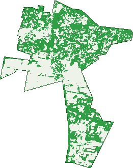
Green: 10 m cells where trees dominate, satellite 2021. Blue: water. The line is the suburb boundary.
| Canopy share, 1 m canopy height map, 2020 | 21.2% |
|---|---|
| Land with trees, 10 m satellite map, 2021 | 51.1% |
Demographics
Unemployment 3.5% · Labour-force participation 63.8%
Population by age in Kilsyth
| 0-4 | 812 |
|---|---|
| 5-14 | 1,371 |
| 15-19 | 589 |
| 20-24 | 609 |
| 25-34 | 1,797 |
| 35-44 | 1,673 |
| 45-54 | 1,279 |
| 55-64 | 1,295 |
| 65-74 | 1,132 |
| 75-84 | 822 |
| 85+ | 324 |
Dwelling types in Kilsyth
| House | 3,887 |
|---|---|
| Townhouse | 647 |
| Apartment | 58 |
| Other | 0 |
Households by weekly income in Kilsyth
| <$650 | 748 |
|---|---|
| $650-1,499 | 1,249 |
| $1,500-2,999 | 1,555 |
| $3,000+ | 781 |
Top ancestries in Kilsyth
| English | 4,800 |
|---|---|
| Australian | 4,480 |
| Other | 1,390 |
| Irish | 1,210 |
| Scottish | 1,196 |
| German | 538 |
Housing tenure in Kilsyth
| Owned | 1,490 |
|---|---|
| Mortgage | 1,991 |
| Rented | 908 |
| Other | 139 |
Cars per household in Kilsyth
| 0 | 204 |
|---|---|
| 1 | 1,620 |
| 2 | 1,855 |
| 3 | 534 |
| 4+ | 326 |
Commute to work in Kilsyth
| Car | 3,683 |
|---|---|
| Train | 44 |
| Bus | 25 |
| Tram/ferry | 0 |
| Walked | 47 |
| Bicycle | 16 |
| Home | 1,163 |
Top countries of birth in Kilsyth
| England | 503 |
|---|---|
| Myanmar | 374 |
| New Zealand | 142 |
| India | 131 |
| Netherlands | 128 |
| Germany | 89 |
Languages used at home in Kilsyth
| Mandarin | 92 |
|---|---|
| Persian | 57 |
| Greek | 48 |
| German | 46 |
| Sinhalese | 46 |
| Punjabi | 39 |
Birds & Wildlife Nearby
46,623 bird observations recorded near Kilsyth — most often seen:
- Australian Magpie (2,436)
- Noisy Miner (2,411)
- Little Raven (2,391)
- Sulphur-crested Cockatoo (2,301)
- Rainbow Lorikeet (2,245)
- Common Myna (2,234)
- Crimson Rosella (2,059)
- Grey Butcherbird (1,880)
- Red Wattlebird (1,797)
- Magpie-lark (1,658)
- Laughing Kookaburra (1,612)
- Pied Currawong (1,587)
- Australian Wood Duck (1,577)
Show all 30 birds recorded near Kilsyth
- Eastern Rosella (1,510)
- Eurasian Blackbird (1,486)
- Brown Thornbill (1,447)
- Spotted Turtle-dove (1,420)
- Welcome Swallow (1,407)
- Pacific Black Duck (1,370)
- Grey Fantail (1,286)
- Southern Victoria Australian Magpie (1,245)
- Superb Fairy-wren (1,243)
- Galah (1,161)
- Australasian Purple Swamphen (1,098)
- White-faced Heron (1,061)
- Australian King-parrot (990)
- Eurasian Coot (941)
- Australian White Ibis (926)
- Crested Pigeon (925)
- Dusky Moorhen (919)
Sightings reported by observers, not a survey, so the counts show what people record rather than what lives here. Source: Atlas of Living Australia.
Nearby Suburbs
The closest suburbs to Kilsyth:
- Montrose (2.5 km)
- Kilsyth South (2.8 km)
- Mooroolbark (2.8 km)
- Croydon (3.2 km)
- Croydon South (3.7 km)
- Bayswater North (4 km)
- Croydon North (4.7 km)
- Mount Dandenong (5 km)
Embed this suburb
Add this free Kilsyth stat card to your own site — just copy the code:
Preview:
Cite this page
Quoting these figures? Copy the credit line:
Keep an eye on Kilsyth
One email when this data meaningfully changes — new census figures, prices, rankings. No spam, unsubscribe anytime.
Streets
- Aaron Place (10)
- Acacia Avenue (15)
- Alamein Avenue (32)
- Alastair Court (14)
- Alpine Way (80)
- Amber Court (16)
- Amelia Court (16)
- Anita Street (36)
- Antancia Close (8)
- Argyle Close (6)
- Arnold Street (12)
- Ashby Way (26)
- Astor Court (10)
- Atherton Court (13)
- Autumn Way (18)
- Bainbridge Court (18)
- Ballantyne Crescent (49)
- Balmoral Street (102)
- Bandicoot Place (7)
- Beatrice Street (41)
- Beech Street (6)
- Belinda Close (57)
- Belvoir Court (5)
- Birkenhead Drive (95)
- Bluemetal Drive (34)
- Brad Close (5)
- Brennan Close (4)
- Bristol Court (28)
- Brompton Court (23)
- Browning Street (58)
- Buttler Street (14)
- Byron Road (68)
- Calvin Close (5)
- Camaro Place (10)
- Cambridge Road (123)
- Cameron Court (22)
- Canterbury Road (160)
- Carina Court (7)
- Caroline Street (22)
- Catherine Court (2)
- Chamomile Close (5)
- Charger Circuit (15)
- Charles Street (18)
- Cheryl Street (1)
- Cherylnne Crescent (189)
- Church Street (25)
- Churchill Way (62)
- Clayton Place (4)
- Coffee Close (4)
- Colchester Road (164)
- Colebrook Road (3)
- Collins Place (28)
- Colver Close (5)
- Cornelia Close (13)
- Corvette Place (10)
- Cosmo Court (20)
- Cradley Court (15)
- Crinan Street (29)
- Dallas Court (8)
- Danjul Close (14)
- Dante Close (5)
- David Close (8)
- Deborah Street (18)
- Denman Street (16)
- Derby Road (27)
- Donald Close (8)
- Duggie Mews (4)
- Dunrossil Drive (29)
- Durham Road (159)
- Dyffryn Court (8)
- Eden Way (33)
- Edenhope Street (33)
- Emerald Close (8)
- Eothen Lane (66)
- Erica Crescent (25)
- Ervin Road (125)
- Eva Court (5)
- Evelyn Place (8)
- Eversen Lane (5)
- Fairmont Drive (9)
- Faith Close (3)
- Fergerson Road (2)
- Ferguson Road (2)
- Fernbank Court (17)
- Finsbury Court (9)
- Fir Court (5)
- Flinders Court (8)
- Florence Street (9)
- Forest Way (8)
- Fussell Road (12)
- Garden Street (67)
- Geoffrey Drive (154)
- Gladesville Drive (58)
- Glasgow Road (40)
- Glen Dhu Road (87)
- Glendale Court (46)
- Graham Avenue (56)
- Greeves Drive (204)
- Grierson Drive (37)
- Hamilton Close (13)
- Hammersley Court (6)
- Hanna Court (6)
- Hansen Road (32)
- Hansford Close (9)
- Harold Close (7)
- Hawthory Road (122)
- Hayes Court (6)
- Hi-tech Court (20)
- Hildegard Court (10)
- Hillview Drive (60)
- Homer Fraser Avenue (17)
- Idinia Street (20)
- Indy Close (7)
- Innisfree Walk (7)
- Isabella Place (4)
- Jacaranda Avenue (41)
- Jeanette Maree Court (14)
- Jemma Close (4)
- Kalina Court (14)
- Kevin Court (38)
- Kiel Close (36)
- Kilborn Court (14)
- Kiloran Avenue (32)
- Kilsyth Avenue (33)
- Lade Avenue (29)
- Landstrom Quadrant (71)
- Landy Court (18)
- Lena Grove (39)
- Leonard Road (10)
- Lexi Place (7)
- Lightwood Close (7)
- Linley Court (27)
- Liverpool Road (395)
- Lobosco Court (6)
- Loch Street (23)
- Lockhart Court (44)
- Lomond Avenue (213)
- Louisa Street (3)
- Lucas Avenue (32)
- Lucinley Close (13)
- Luscombe Court (36)
- Macdonnell Court (6)
- Maple Court (23)
- Margaret Street (56)
- Marion Avenue (13)
- Merrindale Drive (47)
- Mersey Road (17)
- Milford Street (38)
- Mimosa Avenue (40)
- Moira Road (20)
- Molly Close (6)
- Montgomery Court (26)
- Montrose Road (18)
- Monty Close (5)
- Morrison Crescent (34)
- Mount Dandenong Road (1)
- Mountain View Road (93)
- Mountfield Road (48)
- Mt Dandenong Road (417)
- Natanya Way (15)
- Niko Close (7)
- North Road (3)
- Orchard Street (75)
- Oscar Place (4)
- Oswin Court (10)
- Pacific Place (14)
- Palm Grove (51)
- Paperbark Close (6)
- Paramount Avenue (23)
- Pascoe Avenue (23)
- Pavitt Lane (12)
- Pendle Place (6)
- Piccadilly Court (32)
- Pitt Road (8)
- Platinum Way (6)
- Pleasant Street (54)
- Regina Street (43)
- Russo Place (17)
- Sage Close (6)
- Scarlett Close (13)
- Scenic Rise (6)
- Scots Close (5)
- Senar Street (12)
- Serenity Close (4)
- Shamsi Close (6)
- Sheffield Road (12)
- Shelley Avenue (27)
- Shelley Court (18)
- Shield Court (13)
- Silverado Place (8)
- Skye Close (7)
- Solander Close (5)
- Sophie Street (22)
- Steel Close (4)
- Stirling Court (9)
- Strathbogie Court (20)
- Strzelecki Court (8)
- Tamworth Road (78)
- Tennyson Avenue (56)
- Terrigal Crescent (99)
- Theodore Close (4)
- Ti-tree Court (11)
- Timms Avenue (49)
- Timms Court (9)
- Tinarra Court (18)
- Tools Close (4)
- Tower Street (17)
- Treetop Drive (20)
- Urana Street (86)
- Urban Close (5)
- Van Close (5)
- Venus Close (5)
- View Hill Close (6)
- Walnut Drive (55)
- Wannan Court (22)
- Wavell Avenue (29)
- Wendels Close (8)
- West Court (6)
- Wildflower Place (8)
- Willow Court (17)
- Wisteria Close (8)
- Yolanda Court (12)
- Zoe Close (4)