Ashwood VIC 3147
4,034 addresses · 92 streets
Chisholm Electorate › Monash LGA › Ashwood · 14 km from Melbourne
📦 Thinking of moving here? Read the Ashwood moving guide

Living Here
Ashwood is a suburb of Victoria, home to about 7,154 people, with a median age of 39. The typical household earns around $1,909 a week, with median rent near $391 a week. Most homes are houses. About 61% of households own their home and 37% rent. Most workers drive to work. Common community backgrounds include English, Australian, Chinese. On the ABS socio-economic scale it sits in decile 9 of 10 nationally — a relatively advantaged area. The median house sells for about $1,442,500.
Over time — Census 2001 → 2021
Dashed line: district figures for the Ashwood - Chadstone statistical area (SA2), the smallest area the ABS published before 2011. Solid line: Ashwood itself.
Getting Around & Local Services
Getting around. Train station: Jordanville, 1.2 km south-east · Tram stop: Stop 59: Somers Street, 1.9 km north · Railway halt: Box Hill, 7.6 km north · Bus interchange: Chadstone Shopping Centre, 2.8 km south-west · Airport: Moorabbin Airport, 12.4 km south.
Sport & Recreation
5 facilities recorded in Ashwood.
- Ashwood College Cricket, Netball
- Ashwood Reserve Hockey, Soccer
- Electra Reserve Callisthenics, Croquet
- Jingella Reserve Cricket, Rugby Union
- Oakleigh Youth Club Boxing
Socio-economic Standing
Deciles from 1 (lowest) to 10 (highest), against all Australian suburbs. The overall figure weighs advantage and disadvantage together; economic resources counts income and housing, and education & jobs counts qualifications and occupation. They often differ. Source: ABS SEIFA 2021.
Median Sale Prices
Median of recorded sales in the period, not a valuation. Source: Victorian Property Sales Report, Land Use Victoria.
Tree cover
🌳 Tree canopy: 12.9% share of land under canopy · satellite map, 2020
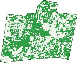
Green: 10 m cells where trees dominate, satellite 2021. Blue: water. The line is the suburb boundary.
| Canopy share, 1 m canopy height map, 2020 | 12.9% |
|---|---|
| Land with trees, 10 m satellite map, 2021 | 51.9% |
Demographics
Unemployment 6.1% · Labour-force participation 62.2%
Population by age in Ashwood
| 0-4 | 373 |
|---|---|
| 5-14 | 828 |
| 15-19 | 408 |
| 20-24 | 439 |
| 25-34 | 1,041 |
| 35-44 | 1,017 |
| 45-54 | 959 |
| 55-64 | 802 |
| 65-74 | 605 |
| 75-84 | 413 |
| 85+ | 259 |
Dwelling types in Ashwood
| House | 1,563 |
|---|---|
| Townhouse | 326 |
| Apartment | 789 |
| Other | 3 |
Households by weekly income in Ashwood
| <$650 | 534 |
|---|---|
| $650-1,499 | 571 |
| $1,500-2,999 | 623 |
| $3,000+ | 826 |
Top ancestries in Ashwood
| English | 1,760 |
|---|---|
| Australian | 1,528 |
| Chinese | 1,383 |
| Other | 1,015 |
| Irish | 651 |
| Scottish | 512 |
Housing tenure in Ashwood
| Owned | 786 |
|---|---|
| Mortgage | 839 |
| Rented | 986 |
| Other | 39 |
Cars per household in Ashwood
| 0 | 244 |
|---|---|
| 1 | 1,062 |
| 2 | 972 |
| 3 | 251 |
| 4+ | 117 |
Commute to work in Ashwood
| Car | 1,465 |
|---|---|
| Train | 78 |
| Bus | 33 |
| Tram/ferry | 4 |
| Walked | 31 |
| Bicycle | 7 |
| Home | 1,341 |
Top countries of birth in Ashwood
| China | 693 |
|---|---|
| India | 219 |
| England | 178 |
| Malaysia | 161 |
| Sri Lanka | 153 |
| Greece | 97 |
Languages used at home in Ashwood
| Mandarin | 799 |
|---|---|
| Cantonese | 264 |
| Greek | 260 |
| Sinhalese | 129 |
| Hindi | 95 |
| Korean | 90 |
Birds & Wildlife Nearby
296,945 bird observations recorded near Ashwood — most often seen:
- Little Raven (24,284)
- Rainbow Lorikeet (20,139)
- Noisy Miner (19,952)
- Australian Magpie (19,150)
- Common Myna (17,259)
- Spotted Turtle-dove (15,749)
- Red Wattlebird (13,307)
- Pacific Black Duck (11,649)
- Magpie-lark (10,912)
- Southern Victoria Australian Magpie (10,307)
- Southern Noisy Miner (9,944)
- Eurasian Blackbird (9,623)
- Eastern Rainbow Lorikeet (9,459)
Show all 30 birds recorded near Ashwood
- Grey Butcherbird (9,419)
- Eastern Asian Spotted Dove (8,387)
- Pied Currawong (7,995)
- Brown Thornbill (6,554)
- Common Starling (6,480)
- Eastern Red Wattlebird (6,208)
- Chestnut Teal (6,082)
- South-eastern Grey Butcherbird (6,071)
- Crested Pigeon (5,956)
- Dusky Moorhen (5,817)
- Welcome Swallow (5,646)
- Rock Dove (5,634)
- Southern Magpie-lark (5,490)
- Australasian Purple Swamphen (5,164)
- Little Wattlebird (4,941)
- White-plumed Honeyeater (4,730)
- Australian Wood Duck (4,637)
Sightings reported by observers, not a survey, so the counts show what people record rather than what lives here. Source: Atlas of Living Australia.
Nearby Suburbs
The closest suburbs to Ashwood:
- Chadstone (1.6 km)
- Ashburton (1.8 km)
- Burwood (2.1 km)
- Mount Waverley (2.7 km)
- Malvern East (3.6 km)
- Oakleigh (3.8 km)
- Glen Iris (3.8 km)
- Hughesdale (3.9 km)
Embed this suburb
Add this free Ashwood stat card to your own site — just copy the code:
Preview:
Cite this page
Quoting these figures? Copy the credit line:
Keep an eye on Ashwood
One email when this data meaningfully changes — new census figures, prices, rankings. No spam, unsubscribe anytime.
Streets
- Allambi Street (24)
- Arilpa Court (14)
- Arthur Street (36)
- Ashwood Drive (116)
- Avoca Court (7)
- Aweta Street (12)
- Barrington Drive (76)
- Baryn Street (5)
- Beechwood Terrace (14)
- Boston Street (11)
- Brooke Court (6)
- Carlyle Street (49)
- Cassinia Avenue (61)
- Clearview Close (7)
- Cleveland Road (108)
- Closter Avenue (45)
- Condah Court (21)
- Crundale Street (5)
- Cudgee Court (23)
- Delta Avenue (12)
- Douglas Street (76)
- Edmonds Avenue (69)
- Eildon Road (43)
- Electra Avenue (64)
- Elliott Street (78)
- Farmer Street (13)
- George Street (77)
- Gubbah Court (28)
- Harcourt Street (39)
- Harold Street (13)
- Hazel Court (14)
- Heather Avenue (32)
- High Street Road (200)
- Hume Court (24)
- Huntingdale Road (119)
- Jamboree Lane (1)
- Jingella Avenue (102)
- Jordan Street (88)
- Julie Court (9)
- Kanooka Avenue (24)
- Karrin Court (18)
- Katta Court (33)
- Keats Court (9)
- Kennett Street (7)
- Kiewa Street (24)
- Lavender Court (14)
- Lavidge Road (64)
- Leonard Street (32)
- Malmsbury Drive (3)
- Maroondah Road (19)
- Mavron Street (12)
- May Park Avenue (71)
- Mitchell Avenue (25)
- Montpellier Road (12)
- Montrose Street (47)
- Moore Street (12)
- Morris Street (7)
- Morton Road (32)
- Mountain Ash Avenue (40)
- Mulgrave Street (56)
- Murra Court (47)
- Newbury Court (5)
- Nolan Court (6)
- Parkhill Drive (43)
- Peppermint Court (14)
- Poplar Avenue (3)
- Power Avenue (274)
- Queens Parade (84)
- Railway Avenue (28)
- Raymond Street (61)
- Reid Street (55)
- Rocklands Road (29)
- Salisbury Road (86)
- Scenic Drive (17)
- Shaw Street (68)
- Shelley Court (5)
- Silver Ash Avenue (63)
- Station Avenue (32)
- Sylvan Crescent (28)
- Teck Street (77)
- Temple Street (97)
- Tooronga Court (7)
- Vannam Drive (85)
- Warrigal Road (121)
- Winbirra Parade (187)
- Wippa Court (22)
- Woolert Street (29)
- Wugga Court (15)
- Yertchuk Avenue (71)
- Yileen Court (14)
- Yooralla Street (39)
- Yunki Court (20)