Parafield Gardens SA 5107
7,765 addresses · 294 streets
Makin Electorate › Salisbury LGA › Parafield Gardens · 16 km from Adelaide
📦 Thinking of moving here? Read the Parafield Gardens moving guide

Living Here
Parafield Gardens is a suburb of South Australia, home to about 18,467 people, with a median age of 36. The typical household earns around $1,384 a week, with median rent near $300 a week. Most homes are houses. About 69% of households own their home and 29% rent. Most workers drive to work. Common community backgrounds include English, Australian, Indian. On the ABS socio-economic scale it sits in decile 1 of 10 nationally — a more disadvantaged area. The median house sells for about $875,500.
Over time — Census 2001 → 2021
Dashed line: district figures for the Parafield Gardens statistical area (SA2), the smallest area the ABS published before 2011. Solid line: Parafield Gardens itself.
Getting Around & Local Services
6 supermarkets
2 Catholic churches
1 medical clinic
1 dentist
1 physiotherapist
2 optometrists
1 post office
1 bakery
1 hardware store
2 hairdressers
Getting around. Train station: Parafield Gardens, 1.5 km south-east · Bus interchange: Mawson Interchange, 2.3 km south · Airport: Adelaide Airport, 19.1 km south.
Socio-economic Standing
Deciles from 1 (lowest) to 10 (highest), against all Australian suburbs. The overall figure weighs advantage and disadvantage together; economic resources counts income and housing, and education & jobs counts qualifications and occupation. They often differ. Source: ABS SEIFA 2021.
Median Sale Prices
Median of recorded sales in the period, not a valuation. Source: Metropolitan Median House Sales, Valuer-General South Australia.
Tree cover
🌳 Tree canopy: 11.8% share of land under canopy · satellite map, 2020
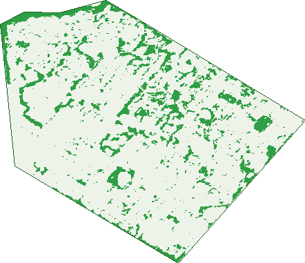
Green: 10 m cells where trees dominate, satellite 2021. Blue: water. The line is the suburb boundary.
| Canopy share, 1 m canopy height map, 2020 | 11.8% |
|---|---|
| Land with trees, 10 m satellite map, 2021 | 10.0% |
Demographics
Unemployment 8.2% · Labour-force participation 57.1%
Population by age in Parafield Gardens
| 0-4 | 1,236 |
|---|---|
| 5-14 | 2,591 |
| 15-19 | 1,138 |
| 20-24 | 1,263 |
| 25-34 | 2,631 |
| 35-44 | 2,667 |
| 45-54 | 2,073 |
| 55-64 | 2,148 |
| 65-74 | 1,567 |
| 75-84 | 875 |
| 85+ | 276 |
Dwelling types in Parafield Gardens
| House | 5,483 |
|---|---|
| Townhouse | 513 |
| Apartment | 130 |
| Other | 0 |
Households by weekly income in Parafield Gardens
| <$650 | 1,057 |
|---|---|
| $650-1,499 | 2,079 |
| $1,500-2,999 | 1,977 |
| $3,000+ | 631 |
Top ancestries in Parafield Gardens
| Other | 5,043 |
|---|---|
| English | 4,534 |
| Australian | 4,330 |
| Indian | 1,361 |
| Vietnamese | 1,319 |
| Ancestry NS | 942 |
Housing tenure in Parafield Gardens
| Owned | 1,691 |
|---|---|
| Mortgage | 2,461 |
| Rented | 1,723 |
| Other | 159 |
Cars per household in Parafield Gardens
| 0 | 387 |
|---|---|
| 1 | 1,970 |
| 2 | 2,337 |
| 3 | 919 |
| 4+ | 442 |
Commute to work in Parafield Gardens
| Car | 6,022 |
|---|---|
| Train | 7 |
| Bus | 221 |
| Tram/ferry | 0 |
| Walked | 42 |
| Bicycle | 8 |
| Home | 378 |
Top countries of birth in Parafield Gardens
| India | 1,515 |
|---|---|
| Vietnam | 933 |
| England | 657 |
| Afghanistan | 655 |
| Philippines | 456 |
| Cambodia | 414 |
Languages used at home in Parafield Gardens
| Vietnamese | 1,382 |
|---|---|
| Punjabi | 776 |
| Gujarati | 621 |
| Khmer | 605 |
| Arabic | 286 |
| Tagalog | 230 |
Birds & Wildlife Nearby
43,673 bird observations recorded near Parafield Gardens — most often seen:
- Pacific Black Duck (1,996)
- Australian White Ibis (1,988)
- Eurasian Coot (1,894)
- Grey Teal (1,848)
- Chestnut Teal (1,816)
- White-faced Heron (1,739)
- Dusky Moorhen (1,709)
- Australasian Purple Swamphen (1,698)
- Australasian Grebe (1,653)
- Little Pied Cormorant (1,645)
- Rainbow Lorikeet (1,565)
- Little Raven (1,538)
- Common Starling (1,505)
Show all 30 birds recorded near Parafield Gardens
- Magpie-lark (1,481)
- Eurasian Blackbird (1,460)
- House Sparrow (1,447)
- Spotted Turtle-dove (1,436)
- Crested Pigeon (1,319)
- Rock Dove (1,297)
- Willie Wagtail (1,259)
- Superb Fairy-wren (1,207)
- Royal Spoonbill (1,205)
- Australian Pelican (1,161)
- Noisy Miner (1,146)
- Black-tailed Native-hen (1,138)
- Welcome Swallow (1,122)
- New Holland Honeyeater (1,116)
- Black Swan (1,109)
- Australian Wood Duck (1,095)
- White-plumed Honeyeater (1,081)
Sightings reported by observers, not a survey, so the counts show what people record rather than what lives here. Source: Atlas of Living Australia.
Nearby Suburbs
The closest suburbs to Parafield Gardens:
- Green Fields (1.5 km)
- Salisbury Downs (1.8 km)
- Globe Derby Park (2 km)
- Mawson Lakes (2.9 km)
- Salisbury South (2.9 km)
- Paralowie (2.9 km)
- Parafield (3 km)
- Bolivar (3.2 km)
Embed this suburb
Add this free Parafield Gardens stat card to your own site — just copy the code:
Preview:
Cite this page
Quoting these figures? Copy the credit line:
Keep an eye on Parafield Gardens
One email when this data meaningfully changes — new census figures, prices, rankings. No spam, unsubscribe anytime.
Streets
- Addison Street (22)
- Agius Court (7)
- Airdrie Avenue (27)
- Andrew Smith Drive (124)
- Anna Street (12)
- Anson Avenue (7)
- Armstrong Avenue (20)
- Aspen Lane (11)
- Athalie Avenue (45)
- Audrey Avenue (21)
- Banksia Crescent (35)
- Barbara Street (2)
- Bardsley Avenue (25)
- Barnes Crescent (17)
- Bauhinia Drive (33)
- Beckett Street (21)
- Begonia Court (24)
- Berno Court (21)
- Birch Grove (12)
- Birchen Avenue (7)
- Blackie Avenue (10)
- Blueberry Road (35)
- Blyth Avenue (21)
- Boston Avenue (15)
- Bradbury Street (28)
- Bradman Road (82)
- Bresse Street (4)
- Briar Court (5)
- Brooke Street (15)
- Browning Crescent (46)
- Buckland Street (8)
- Burge Street (8)
- Burstall Court (20)
- Bye Street (5)
- Camelia Drive (37)
- Carmelina Court (28)
- Carmine Court (26)
- Carnation Court (19)
- Carpenter Road (27)
- Carson Street (31)
- Casuarina Drive (35)
- Catalina Avenue (77)
- Cedar Avenue (5)
- Chard Court (13)
- Chesser Street (26)
- Chestnut Drive (27)
- Clive Road (9)
- Clover Street (4)
- Colton Court (5)
- Cook Street (18)
- Cypress Drive (102)
- Daisy Court (8)
- Denver Drive (33)
- Derwent Street (7)
- Devlin Court (12)
- Diana Avenue (14)
- Dineen Road (34)
- Diosma Avenue (7)
- Doris Court (8)
- Duffy Court (3)
- Eddington Street (38)
- Electra Avenue (12)
- Elm Court (11)
- Erica Court (10)
- Eugene Crescent (50)
- Eurimbla Street (17)
- Eve Court (5)
- Falcon Drive (40)
- Fern Court (16)
- Fiedler Court (5)
- Field Street (59)
- Flavio Avenue (28)
- Gardenia Drive (29)
- Geare Court (6)
- Gepps Avenue (10)
- Golden Circuit (30)
- Grace Court (9)
- Grandview Terrace (4)
- Gratton Court (3)
- Green Street (6)
- Grevillia Drive (37)
- Grimmett Avenue (24)
- Grives Court (9)
- Grove Street (8)
- Gunett Court (7)
- Gurney Street (11)
- Hahn Court (14)
- Halifax Avenue (40)
- Hanlin Court (6)
- Hart Court (5)
- Hasse Court (14)
- Hatherleigh Road (42)
- Hawthorn Terrace (20)
- Helena Avenue (12)
- Hemming Street (8)
- Heron Avenue (14)
- Hibiscus Court (16)
- Hilda Court (14)
- Hodges Court (10)
- Holly Court (15)
- Holmefield Court (8)
- Homestead Place (10)
- Horsens Way (22)
- Howell Road (41)
- Hutchinson Drive (25)
- Ibis Way (2)
- Jackson Street (32)
- James Court (5)
- Jamison Street (17)
- Japonica Crescent (43)
- Jarman Way (3)
- Jennifer Terrace (35)
- Jessie Goodes Court (10)
- Joanne Terrace (56)
- Jocelyn Terrace (27)
- Joes Court (11)
- Kate Street (4)
- Kathryn Place (9)
- Kelleway Street (20)
- Kermath Court (5)
- Kingborn Road (6)
- Kings Road (47)
- Lake Street (13)
- Lakeview Drive (14)
- Lamorna Parade (34)
- Lancaster Avenue (40)
- Lantana Drive (65)
- Laurel Crescent (42)
- Lavender Drive (90)
- Leaf Street (25)
- Lilac Court (47)
- Lincoln Avenue (53)
- Lindwall Street (6)
- Linwood Crescent (27)
- Lobelia Drive (26)
- Lovelock Road (75)
- Macartney Road (39)
- Mackay Crescent (33)
- Magnolia Crescent (23)
- Mahogany Circuit (48)
- Mailey Crescent (36)
- Malta Drive (17)
- Maple Avenue (3)
- Martindale Road (19)
- Martins Road (217)
- Maynard Crescent (10)
- Mccabe Avenue (39)
- Mcdonald Road (43)
- Mctaggart Court (6)
- Meredith Street (6)
- Miller Crescent (17)
- Minorca Court (10)
- Miriam Road (20)
- Misale Street (4)
- Mitchell Street (18)
- Monarch Avenue (11)
- Mordaunt Street (22)
- Morgan Street (55)
- Mornes Court (7)
- Moss Street (34)
- Myrtle Court (16)
- Nathan Street (23)
- Nellie Street (17)
- New Hampshire Drive (44)
- Newlyn Terrace (6)
- Nuddea Place (15)
- O'neill Street (15)
- O'reilly Street (28)
- Oaks Court (8)
- Oakwood Street (5)
- Ohio Court (5)
- Oldfield Street (32)
- Oleander Drive (84)
- Olive Court (11)
- Oliver Street (6)
- Ormsby Avenue (18)
- Oxford Street (16)
- Palm Court (45)
- Park Street (5)
- Parkway Circuit (77)
- Pearson Street (37)
- Pelican Road (2)
- Pellew Street (15)
- Peony Court (6)
- Peppertree Court (7)
- Petrel Court (5)
- Piper Street (69)
- Ponsford Crescent (18)
- Port Wakefield Road (15)
- Primrose Court (28)
- Quick Street (17)
- Quondong Avenue (65)
- Ralph Court (16)
- Raner Avenue (31)
- Rankine Street (6)
- Red Gum Court (7)
- Redwood Drive (27)
- Reed Court (5)
- Resthaven Road (47)
- Rhode Island Drive (47)
- Rhus Avenue (4)
- Richardson Street (17)
- Richmond Road (48)
- Ritchie Court (8)
- Riverwalk Place (16)
- Rodam Court (7)
- Rolls Court (7)
- Rosalie Terrace (66)
- Rosecombe Place (21)
- Rosemary Avenue (30)
- Rosewood Court (17)
- Rowan Court (8)
- Roxby Street (9)
- Royal Palm Drive (36)
- Rundle Drive (541)
- Rush Court (5)
- Russo Avenue (18)
- Ryans Road (39)
- Ryder Avenue (34)
- Sage Court (8)
- Saint Alfred Drive (45)
- Salas Road (26)
- Salisbury Highway (221)
- Salmon Court (7)
- Sanderson Court (15)
- Sapphire Terrace (19)
- Scholes Avenue (25)
- Seabright Avenue (30)
- Secomb Avenue (67)
- Sharon Avenue (28)
- Shelby Street (2)
- Shepherdson Road (141)
- Shirley Avenue (24)
- Shorney Road (42)
- Silkie Court (8)
- Simon Court (9)
- Sophia Street (4)
- Southcott Terrace (2)
- Spencer Street (21)
- Springbank Place (32)
- Springwood Avenue (9)
- St Alfred Drive (44)
- St Ives Drive (33)
- Stirling Street (1)
- Stone Court (8)
- Stuart Court (6)
- Sunderland Avenue (19)
- Susan Street (1)
- Swallow Crescent (56)
- Sweet Street (1)
- Symor Court (17)
- Tahlia Court (32)
- Tallon Street (19)
- Tamir Road (9)
- Taylor Street (19)
- Teasdale Crescent (39)
- Tecoma Court (21)
- The Boulevard (104)
- Townsend Avenue (17)
- Tregenza Court (42)
- Tripodi Circuit (49)
- Trumper Avenue (31)
- Trundle Court (12)
- Tulip Court (7)
- Tye Street (1)
- Tyler Court (3)
- Valetta Court (22)
- Valma Avenue (7)
- Vartue Street (16)
- Ventra Street (12)
- Ventura Street (1)
- Verbena Drive (66)
- Victoria Drive (49)
- Virginia Drive (10)
- Wakeling Crescent (27)
- Walker Street (19)
- Walnut Avenue (21)
- Warming Street (9)
- Washington Street (25)
- Watkin Street (19)
- Wattle Grove (29)
- Wellington Avenue (33)
- Whites Road (77)
- Whitley Street (3)
- Willow Place (4)
- Wilson Court (6)
- Wingate Crescent (29)
- Wood Street (11)
- Woodfull Street (37)
- Woodside Court (5)
- Wyatt Road (83)
- Xavier Place (26)
- Yule Court (4)
- Zeta Court (6)