Paralowie SA 5108
7,126 addresses · 290 streets
Spence Electorate › Salisbury LGA › Paralowie · 19 km from Adelaide
📦 Thinking of moving here? Read the Paralowie moving guide

Living Here
Paralowie is a suburb of South Australia, home to about 17,504 people, with a median age of 35. The typical household earns around $1,479 a week, with median rent near $305 a week. Most homes are houses. About 75% of households own their home and 25% rent. Most workers drive to work. Common community backgrounds include English, Australian, Scottish. On the ABS socio-economic scale it sits in decile 1 of 10 nationally — a more disadvantaged area. The median house sells for about $780,000.
Over time — Census 2001 → 2021
Dashed line: district figures for the Paralowie statistical area (SA2), the smallest area the ABS published before 2011. Solid line: Paralowie itself.
Getting Around & Local Services
2 Catholic churches
2 doctors & medical clinics
2 optometrists
1 vet
2 post offices
1 dog park
1 bakery
1 butcher
1 hardware store
1 hairdresser
Getting around. Train station: Salisbury Interchange, 3.3 km east · Bus interchange: Salisbury Interchange, 3.3 km east · Airport: Adelaide Airport, 21.7 km south.
Socio-economic Standing
Deciles from 1 (lowest) to 10 (highest), against all Australian suburbs. The overall figure weighs advantage and disadvantage together; economic resources counts income and housing, and education & jobs counts qualifications and occupation. They often differ. Source: ABS SEIFA 2021.
Median Sale Prices
Median of recorded sales in the period, not a valuation. Source: Metropolitan Median House Sales, Valuer-General South Australia.
Tree cover
🌳 Tree canopy: 12.6% share of land under canopy · satellite map, 2020
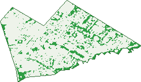
Green: 10 m cells where trees dominate, satellite 2021. Blue: water. The line is the suburb boundary.
| Canopy share, 1 m canopy height map, 2020 | 12.6% |
|---|---|
| Land with trees, 10 m satellite map, 2021 | 14.9% |
Demographics
Unemployment 7.9% · Labour-force participation 62.8%
Population by age in Paralowie
| 0-4 | 1,145 |
|---|---|
| 5-14 | 2,569 |
| 15-19 | 1,198 |
| 20-24 | 1,264 |
| 25-34 | 2,533 |
| 35-44 | 2,510 |
| 45-54 | 2,349 |
| 55-64 | 2,135 |
| 65-74 | 1,288 |
| 75-84 | 433 |
| 85+ | 92 |
Dwelling types in Paralowie
| House | 5,549 |
|---|---|
| Townhouse | 274 |
| Apartment | 55 |
| Other | 6 |
Households by weekly income in Paralowie
| <$650 | 837 |
|---|---|
| $650-1,499 | 1,967 |
| $1,500-2,999 | 2,118 |
| $3,000+ | 609 |
Top ancestries in Paralowie
| English | 5,496 |
|---|---|
| Australian | 5,185 |
| Other | 4,107 |
| Scottish | 948 |
| Irish | 915 |
| Vietnamese | 866 |
Housing tenure in Paralowie
| Owned | 1,418 |
|---|---|
| Mortgage | 2,923 |
| Rented | 1,430 |
| Other | 42 |
Cars per household in Paralowie
| 0 | 262 |
|---|---|
| 1 | 1,872 |
| 2 | 2,309 |
| 3 | 868 |
| 4+ | 519 |
Commute to work in Paralowie
| Car | 6,418 |
|---|---|
| Train | 4 |
| Bus | 143 |
| Tram/ferry | 4 |
| Walked | 59 |
| Bicycle | 23 |
| Home | 308 |
Top countries of birth in Paralowie
| England | 651 |
|---|---|
| Vietnam | 588 |
| Afghanistan | 567 |
| Cambodia | 462 |
| India | 450 |
| Philippines | 310 |
Languages used at home in Paralowie
| Vietnamese | 843 |
|---|---|
| Khmer | 716 |
| Punjabi | 260 |
| Arabic | 248 |
| Spanish | 217 |
| Tagalog | 164 |
Birds & Wildlife Nearby
34,027 bird observations recorded near Paralowie — most often seen:
- Australian White Ibis (1,503)
- Pacific Black Duck (1,449)
- Grey Teal (1,445)
- Chestnut Teal (1,372)
- White-faced Heron (1,348)
- Rainbow Lorikeet (1,337)
- Common Starling (1,315)
- Little Raven (1,302)
- Eurasian Coot (1,290)
- House Sparrow (1,269)
- Australasian Grebe (1,238)
- Spotted Turtle-dove (1,190)
- Dusky Moorhen (1,188)
Show all 30 birds recorded near Paralowie
- Magpie-lark (1,182)
- Australasian Purple Swamphen (1,178)
- Eurasian Blackbird (1,128)
- Little Pied Cormorant (1,099)
- Noisy Miner (1,072)
- Willie Wagtail (1,025)
- Crested Pigeon (1,010)
- White-plumed Honeyeater (999)
- Rock Dove (998)
- Red Wattlebird (932)
- Black-tailed Native-hen (926)
- Royal Spoonbill (894)
- Australian Wood Duck (891)
- Australian Magpie (885)
- Silver Gull (859)
- Superb Fairy-wren (852)
- Welcome Swallow (851)
Sightings reported by observers, not a survey, so the counts show what people record rather than what lives here. Source: Atlas of Living Australia.
Nearby Suburbs
The closest suburbs to Paralowie:
- Bolivar (1.7 km)
- Burton (1.7 km)
- Salisbury North (2.1 km)
- Salisbury Downs (2.3 km)
- Parafield Gardens (2.9 km)
- Salisbury (3.2 km)
- Direk (3.3 km)
- Edinburgh (3.6 km)
Embed this suburb
Add this free Paralowie stat card to your own site — just copy the code:
Preview:
Cite this page
Quoting these figures? Copy the credit line:
Keep an eye on Paralowie
One email when this data meaningfully changes — new census figures, prices, rankings. No spam, unsubscribe anytime.
Streets
- Alvaro Street (33)
- Ambervale Court (4)
- Amelia Court (13)
- Amery Road (10)
- Ancona Street (9)
- Angel Place (14)
- Antonas Avenue (9)
- Arras Court (12)
- Arrow Crescent (32)
- Ascot Drive (31)
- Ash Court (12)
- Balmoral Court (11)
- Barassi Street (23)
- Barque Street (6)
- Bartlett Avenue (16)
- Basso Court (6)
- Bayonet Drive (5)
- Beck Court (16)
- Bellbird Avenue (8)
- Belmar Street (26)
- Belperio Close (6)
- Bermudez Crescent (49)
- Bernadette Street (10)
- Birchwood Avenue (3)
- Biscay Court (11)
- Blaess Drive (35)
- Blakiston Court (27)
- Bluegum Drive (25)
- Boardwalk Drive (69)
- Bogart Drive (24)
- Bogota Crescent (29)
- Bolivar Road (45)
- Bolivia Crescent (27)
- Boon Court (18)
- Border Court (8)
- Botham Street (6)
- Boves Court (15)
- Bow Court (5)
- Boyaca Court (21)
- Boyara Crescent (38)
- Brando Court (30)
- Brazil Drive (29)
- Brion Drive (49)
- Briony Way (25)
- Burdett Drive (41)
- Burgundy Road (2)
- Burton Road (202)
- Byron Bay Drive (35)
- Cairney Place (15)
- Caloundra Drive (42)
- Camelot Drive (47)
- Candy Court (5)
- Caracas Crescent (23)
- Caroline Drive (27)
- Caroline Grove (18)
- Casanor Crescent (32)
- Caulfield Crescent (83)
- Cawarra Crescent (26)
- Century Court (18)
- Charlotte Drive (51)
- Chartwell Crescent (52)
- Cherry Lane (33)
- Chesser Row (14)
- Clancy Road (39)
- Clapton Drive (57)
- Clement Avenue (14)
- Columbia Street (20)
- Conway Court (9)
- Coogee Avenue (33)
- Cooper Place (12)
- Corella Court (4)
- Correena Avenue (37)
- Cottage Close (4)
- Countess Street (22)
- Craig Court (7)
- Crosby Way (29)
- Crown Crescent (24)
- Cruise Court (6)
- Crusader Avenue (9)
- Dale Drive (17)
- Daly Court (6)
- Danehill Drive (26)
- Danzig Avenue (11)
- Dawn Close (6)
- Deacon Court (15)
- Deal Court (14)
- Deanna Avenue (9)
- Delamere Drive (44)
- Dignam Drive (36)
- Du Villars Street (22)
- Duchess Court (15)
- Duke Street (26)
- Dyson Court (14)
- Edward Street (50)
- Elder Court (11)
- Elio Drive (23)
- Ellis Court (8)
- Elm Glade Court (15)
- Elmwood Grove (5)
- Elope Court (6)
- Emu Court (4)
- Enterprise Road (18)
- Equador Street (4)
- Fairbanks Drive (79)
- Fazzolari Circuit (63)
- Fender Court (8)
- Firmin Street (62)
- Fonda Court (12)
- Forest Avenue (23)
- Gable Court (11)
- Gabriella Drive (26)
- Galleon Drive (20)
- Garfield Court (26)
- Gaynor Avenue (15)
- General Drive (81)
- Gerrard Avenue (18)
- Gibson Place (4)
- Gino Street (7)
- Giradof Street (23)
- Glenmore Court (22)
- Glenton Court (7)
- Golden Court (39)
- Greentree Boulevard (50)
- Greig Court (8)
- Gretel Crescent (34)
- Grosvenor Place (17)
- Halba Crescent (17)
- Havenwood Court (3)
- Hazelmere Court (11)
- Heather Close (5)
- Heidi Court (12)
- Hendrix Crescent (29)
- Henry Street (17)
- Heritage Drive (50)
- Heston Court (15)
- Hodgson Road (3)
- Holden Court (18)
- Hookes Court (8)
- Hooper Street (25)
- Hope Drive (43)
- Hudson Court (10)
- Jan Street (10)
- Jessie Road (55)
- Jon Road (4)
- Julian Court (31)
- Kain Court (7)
- Kalimna Crescent (13)
- Kentwood Drive (11)
- Kiera Court (9)
- Kings Road (59)
- Kingswood Crescent (18)
- Koala Crescent (23)
- Lakeside Drive (33)
- Lauren Drive (36)
- Lennox Drive (86)
- Liberator Drive (135)
- Linda Close (6)
- Lombard Avenue (30)
- Lorikeet Close (6)
- Louis Court (26)
- Louisa Road (18)
- Ludwig Street (19)
- Lukin Avenue (32)
- Lydia Street (2)
- Lyndon Road (61)
- Magdalena Crescent (79)
- Majestic Avenue (19)
- Mallee Road (4)
- Mantilla Street (9)
- Manuella Court (12)
- Manx Court (7)
- Margarita Street (24)
- Mario Drive (29)
- Martins Road (52)
- Marvin Way (11)
- Matthew Court (31)
- Max Drive (11)
- Mcnicoll Road (28)
- Mcqueen Court (35)
- Mcvann Avenue (30)
- Melanie Court (12)
- Melvina Road (30)
- Mendez Street (34)
- Mensforth Court (12)
- Merlin Court (7)
- Metala Road (107)
- Middle Avenue (22)
- Mildara Avenue (20)
- Miranda Road (11)
- Mitchell Street (12)
- Mockridge Court (14)
- Moneva Street (9)
- Morris Street (3)
- Mosel Grove (16)
- Mullen Court (20)
- Napoleon Court (24)
- Narino Street (3)
- Nestor Street (2)
- Newbury Crescent (15)
- Newman Avenue (46)
- Nile Street (7)
- Niven Drive (26)
- Nunn Court (6)
- Oakdene Court (16)
- Olivia Street (9)
- Opel Avenue (14)
- Orinoco Street (25)
- Otoma Street (34)
- Padilla Street (17)
- Paez Street (22)
- Panto Avenue (21)
- Para Court (5)
- Parkfield Loop (17)
- Patterson Court (17)
- Paul Court (10)
- Petersen Court (6)
- Piar Street (24)
- Pine View Drive (31)
- Piovesan Drive (31)
- Poplar Road (40)
- Port Wakefield Road (136)
- Prescott Close (6)
- Princess Street (33)
- Prior Court (6)
- Queen Street (16)
- Quinn Drive (4)
- Redford Court (31)
- Reynolds Drive (41)
- Ribas Court (11)
- Rita Drive (39)
- Riva Court (15)
- Rivergum Circuit (33)
- Rodney Court (5)
- Rodriguez Drive (20)
- Rogers Crescent (24)
- Ronaldo Way (15)
- Ross Street (43)
- Rotring Court (7)
- Russell Row (29)
- Sandown Avenue (7)
- Santander Drive (50)
- Segal Court (10)
- Settlers Court (11)
- Shaw Street (8)
- Shelley Drive (13)
- Sherwood Crescent (21)
- Sinatra Way (7)
- Speechley Court (8)
- St Cora Crescent (10)
- Sucre Court (19)
- Swaine Avenue (9)
- Tabitha Avenue (11)
- Tania Street (20)
- Tarqui Drive (82)
- Teresa Court (24)
- The Pines Grove (22)
- Thorne Street (63)
- Thorngate Drive (12)
- Tintara Road (74)
- Tobin Way (13)
- Tolley Close (14)
- Tracey Avenue (57)
- Treetop Court (4)
- Turtur Drive (14)
- Venturi Avenue (15)
- Vera Street (24)
- Vincent Road (44)
- Vincira Crescent (18)
- Vindana Road (41)
- Vokes Place (12)
- Walpole Road (29)
- Walsh Street (3)
- Wanita Court (18)
- Warwick Court (11)
- Waterloo Corner Road (109)
- Waverley Street (13)
- Weaver Boulevard (23)
- Whitehall Court (9)
- Whites Road (204)
- Whittlesea Street (17)
- Wildwood Street (24)
- Willowbrook Boulevard (21)
- Willowbrook Place (11)
- Winston Avenue (13)
- Woodland Way (13)
- Wren Crescent (2)
- Wyman Court (23)
- Yaldara Road (4)
- Yalumba Drive (74)
- Young Boulevard (28)