Northfield SA 5085
2,188 addresses · 69 streets
Adelaide Electorate › Port Adelaide Enfield LGA › Northfield · 9 km from Adelaide
📦 Thinking of moving here? Read the Northfield moving guide

Living Here
Northfield is a suburb of South Australia, home to about 5,043 people, with a median age of 35. The typical household earns around $1,420 a week, with median rent near $307 a week. Most homes are houses. About 58% of households own their home and 42% rent. Most workers drive to work. Common community backgrounds include Ancestry NS, English, Australian. On the ABS socio-economic scale it sits in decile 2 of 10 nationally — a more disadvantaged area. The median house sells for about $885,000.
Over time — Census 2001 → 2021
Dashed line: district figures for the Northgate - Oakden - Gilles Plains statistical area (SA2), the smallest area the ABS published before 2011. Solid line: Northfield itself.
Getting Around & Local Services
6 doctors & medical clinics
4 physiotherapists
3 childcare & kindergartens
2 post offices
1 hairdresser
2 beauty salons
2 electricians
1 plumber
Getting around. Train station: Dry Creek, 3.8 km north-west · Bus interchange: Paradise Interchange, 4.1 km south-east · Airport: Adelaide Airport, 13 km south-west.
Socio-economic Standing
Deciles from 1 (lowest) to 10 (highest), against all Australian suburbs. The overall figure weighs advantage and disadvantage together; economic resources counts income and housing, and education & jobs counts qualifications and occupation. They often differ. Source: ABS SEIFA 2021.
Median Sale Prices
Median of recorded sales in the period, not a valuation. Source: Metropolitan Median House Sales, Valuer-General South Australia.
Tree cover
🌳 Tree canopy: 7.7% share of land under canopy · satellite map, 2020
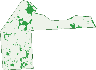
Green: 10 m cells where trees dominate, satellite 2021. Blue: water. The line is the suburb boundary.
| Canopy share, 1 m canopy height map, 2020 | 7.7% |
|---|---|
| Land with trees, 10 m satellite map, 2021 | 7.9% |
Demographics
Unemployment 7.1% · Labour-force participation 48.6%
Population by age in Northfield
| 0-4 | 316 |
|---|---|
| 5-14 | 554 |
| 15-19 | 207 |
| 20-24 | 352 |
| 25-34 | 1,056 |
| 35-44 | 1,015 |
| 45-54 | 552 |
| 55-64 | 407 |
| 65-74 | 314 |
| 75-84 | 198 |
| 85+ | 73 |
Dwelling types in Northfield
| House | 1,268 |
|---|---|
| Townhouse | 264 |
| Apartment | 38 |
| Other | 0 |
Households by weekly income in Northfield
| <$650 | 314 |
|---|---|
| $650-1,499 | 450 |
| $1,500-2,999 | 523 |
| $3,000+ | 177 |
Top ancestries in Northfield
| Other | 1,155 |
|---|---|
| Ancestry NS | 1,011 |
| English | 883 |
| Australian | 830 |
| Indian | 720 |
| Irish | 183 |
Housing tenure in Northfield
| Owned | 313 |
|---|---|
| Mortgage | 571 |
| Rented | 638 |
| Other | 10 |
Cars per household in Northfield
| 0 | 167 |
|---|---|
| 1 | 563 |
| 2 | 581 |
| 3 | 156 |
| 4+ | 77 |
Commute to work in Northfield
| Car | 1,359 |
|---|---|
| Train | 0 |
| Bus | 122 |
| Tram/ferry | 0 |
| Walked | 15 |
| Bicycle | 13 |
| Home | 124 |
Top countries of birth in Northfield
| India | 773 |
|---|---|
| Afghanistan | 140 |
| England | 106 |
| Philippines | 94 |
| Vietnam | 83 |
| China | 78 |
Languages used at home in Northfield
| Gujarati | 399 |
|---|---|
| Punjabi | 302 |
| Hindi | 120 |
| Mandarin | 104 |
| Vietnamese | 101 |
| Nepali | 65 |
Birds & Wildlife Nearby
57,419 bird observations recorded near Northfield — most often seen:
- Australian White Ibis (3,040)
- Dusky Moorhen (2,825)
- Pacific Black Duck (2,741)
- Eurasian Coot (2,425)
- Little Pied Cormorant (2,293)
- Rainbow Lorikeet (2,238)
- Grey Teal (2,228)
- Magpie-lark (2,220)
- Australasian Purple Swamphen (2,138)
- Chestnut Teal (1,981)
- Little Black Cormorant (1,972)
- Australian Pelican (1,966)
- Common Starling (1,925)
Show all 30 birds recorded near Northfield
- Noisy Miner (1,923)
- Rock Dove (1,911)
- White-faced Heron (1,897)
- Spotted Turtle-dove (1,865)
- Black Swan (1,804)
- Australian Magpie (1,767)
- House Sparrow (1,750)
- Welcome Swallow (1,693)
- Crested Pigeon (1,593)
- New Holland Honeyeater (1,542)
- Eurasian Blackbird (1,539)
- Little Raven (1,502)
- Australasian Grebe (1,469)
- Willie Wagtail (1,384)
- Australian Wood Duck (1,310)
- Great Egret (1,247)
- Superb Fairy-wren (1,231)
Sightings reported by observers, not a survey, so the counts show what people record rather than what lives here. Source: Atlas of Living Australia.
Nearby Suburbs
The closest suburbs to Northfield:
- Northgate (0.8 km)
- Clearview (1.1 km)
- Lightsview (1.3 km)
- Enfield (1.9 km)
- Greenacres (2 km)
- Oakden (2 km)
- Walkley Heights (2 km)
- Gepps Cross (2.1 km)
Embed this suburb
Add this free Northfield stat card to your own site — just copy the code:
Preview:
Cite this page
Quoting these figures? Copy the credit line:
Keep an eye on Northfield
One email when this data meaningfully changes — new census figures, prices, rankings. No spam, unsubscribe anytime.
Streets
- Allen Street (12)
- Arthur Street (32)
- Barnes Avenue (46)
- Blackman Avenue (19)
- Bond Street (17)
- Briens Road (50)
- Brown Street (28)
- Carlisle Street (41)
- Charles Street (33)
- Cogdell Court (5)
- Conrad Street (11)
- Cox Terrace (23)
- Davey Street (15)
- Dorothy Avenue (28)
- Druce Avenue (11)
- Dumfries Avenue (65)
- East Avenue (50)
- Firth Avenue (28)
- Folland Avenue (53)
- Glenburnie Avenue (71)
- Goward Street (11)
- Grand Junction Road (74)
- Gray Avenue (12)
- Greenacre Terrace (14)
- Hampstead Road (75)
- Hargrave Street (55)
- Harrington Grove (8)
- Harrison Grove (24)
- Hawke Street (3)
- Holt Street (26)
- Hoods Road (85)
- Howard Road (3)
- James Avenue (13)
- Jolly Avenue (33)
- Justin Avenue (34)
- Laing Street (4)
- Leeds Avenue (54)
- Linden Avenue (26)
- Link Street (7)
- Loch Street (12)
- Maldon Street (15)
- Mansfield Road (32)
- Martin Street (29)
- Mckay Avenue (33)
- Meryl Avenue (14)
- Mostyn Avenue (53)
- Neville Street (15)
- North Avenue (23)
- Northfield Road (73)
- Norton Street (11)
- Peter Brown Drive (1)
- Pettitt Street (3)
- Phillips Street (27)
- Rowe Avenue (118)
- Sefton Avenue (9)
- South Avenue (34)
- Stewart Avenue (48)
- Stirling Street (9)
- Strawson Road (11)
- Swift Court (21)
- Swift Street (61)
- Thompson Avenue (39)
- Twin Street (27)
- West Avenue (144)
- Westbrook Terrace (6)
- Wicklow Street (17)
- Winston Court (21)
- Wright Avenue (36)
- York Street (47)