Lightsview SA 5085
3,358 addresses · 116 streets
Adelaide Electorate › Port Adelaide Enfield LGA › Lightsview · 8 km from Adelaide
📦 Thinking of moving here? Read the Lightsview moving guide

Living Here
Lightsview is a suburb of South Australia, home to about 6,090 people, with a median age of 32. The typical household earns around $1,916 a week, with median rent near $400 a week. Most homes are houses. About 62% of households own their home and 34% rent. Most workers drive to work. Common community backgrounds include English, Australian, Chinese. On the ABS socio-economic scale it sits in decile 9 of 10 nationally — a relatively advantaged area. The median house sells for about $858,000.
Getting Around & Local Services
2 childcare & kindergartens
3 butchers
5 hairdressers
1 beauty salon
1 plumber
Getting around. Train station: Islington, 4.5 km west · Bus interchange: Klemzig Interchange, 2.9 km south · Airport: Adelaide Airport, 12.5 km south-west.
Socio-economic Standing
Deciles from 1 (lowest) to 10 (highest), against all Australian suburbs. The overall figure weighs advantage and disadvantage together; economic resources counts income and housing, and education & jobs counts qualifications and occupation. They often differ. Source: ABS SEIFA 2021.
Median Sale Prices
Median of recorded sales in the period, not a valuation. Source: Metropolitan Median House Sales, Valuer-General South Australia.
Tree cover
🌳 Tree canopy: 5.4% share of land under canopy · satellite map, 2020
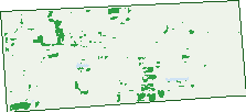
Green: 10 m cells where trees dominate, satellite 2021. Blue: water. The line is the suburb boundary.
| Canopy share, 1 m canopy height map, 2020 | 5.4% |
|---|---|
| Land with trees, 10 m satellite map, 2021 | 2.7% |
Demographics
Unemployment 4.1% · Labour-force participation 73.9%
Population by age in Lightsview
| 0-4 | 423 |
|---|---|
| 5-14 | 617 |
| 15-19 | 224 |
| 20-24 | 491 |
| 25-34 | 1,627 |
| 35-44 | 1,156 |
| 45-54 | 566 |
| 55-64 | 391 |
| 65-74 | 308 |
| 75-84 | 179 |
| 85+ | 92 |
Dwelling types in Lightsview
| House | 1,112 |
|---|---|
| Townhouse | 1,090 |
| Apartment | 214 |
| Other | 0 |
Households by weekly income in Lightsview
| <$650 | 243 |
|---|---|
| $650-1,499 | 613 |
| $1,500-2,999 | 937 |
| $3,000+ | 523 |
Top ancestries in Lightsview
| English | 1,428 |
|---|---|
| Other | 1,221 |
| Australian | 1,095 |
| Chinese | 1,012 |
| Indian | 534 |
| Italian | 415 |
Housing tenure in Lightsview
| Owned | 294 |
|---|---|
| Mortgage | 1,197 |
| Rented | 813 |
| Other | 104 |
Cars per household in Lightsview
| 0 | 92 |
|---|---|
| 1 | 1,078 |
| 2 | 953 |
| 3 | 211 |
| 4+ | 67 |
Commute to work in Lightsview
| Car | 2,524 |
|---|---|
| Train | 0 |
| Bus | 220 |
| Tram/ferry | 0 |
| Walked | 24 |
| Bicycle | 17 |
| Home | 346 |
Top countries of birth in Lightsview
| China | 499 |
|---|---|
| India | 484 |
| England | 169 |
| Malaysia | 157 |
| Philippines | 118 |
| Hong Kong | 103 |
Languages used at home in Lightsview
| Mandarin | 611 |
|---|---|
| Cantonese | 225 |
| Punjabi | 186 |
| Gujarati | 147 |
| Vietnamese | 147 |
| Hindi | 126 |
Birds & Wildlife Nearby
30,737 bird observations recorded near Lightsview — most often seen:
- Rainbow Lorikeet (2,346)
- Noisy Miner (2,152)
- Australian Magpie (1,862)
- Dusky Moorhen (1,442)
- Rock Dove (1,425)
- Australian Wood Duck (1,411)
- Australian White Ibis (1,389)
- Pacific Black Duck (1,290)
- Magpie-lark (1,254)
- New Holland Honeyeater (918)
- Southern Magpie-lark (917)
- Red Wattlebird (913)
- Australasian Purple Swamphen (888)
Show all 30 birds recorded near Lightsview
- Little Raven (850)
- Spotted Turtle-dove (842)
- Galah (841)
- Eastern Crested Pigeon (782)
- Eastern New Holland Honeyeater (777)
- Common Starling (774)
- Crested Pigeon (759)
- Little Pied Cormorant (756)
- Southern Willie Wagtail (752)
- Eurasian Coot (737)
- House Sparrow (725)
- White-plumed Honeyeater (709)
- Eastern Welcome Swallow (676)
- White-faced Heron (671)
- Australasian Grebe (658)
- Eurasian Blackbird (636)
- Eyre Peninsula Australian Magpie (585)
Sightings reported by observers, not a survey, so the counts show what people record rather than what lives here. Source: Atlas of Living Australia.
Nearby Suburbs
The closest suburbs to Lightsview:
- Greenacres (0.7 km)
- Northgate (1.1 km)
- Hillcrest (1.3 km)
- Northfield (1.3 km)
- Hampstead Gardens (1.4 km)
- Clearview (1.4 km)
- Oakden (1.7 km)
- Manningham (1.8 km)
Embed this suburb
Add this free Lightsview stat card to your own site — just copy the code:
Preview:
Cite this page
Quoting these figures? Copy the credit line:
Keep an eye on Lightsview
One email when this data meaningfully changes — new census figures, prices, rankings. No spam, unsubscribe anytime.
Streets
- Africaine Avenue (32)
- Anderson Lane (13)
- Beadle Lane (1)
- Beaumont Street (14)
- Bradley Terrace (33)
- Brandis Way (9)
- Broadstock Street (30)
- Broadway Avenue (11)
- Carrington Lane (9)
- Chard Street (27)
- City View Boulevard (102)
- Cityside Drive (42)
- Clyde Road (19)
- Condon Drive (52)
- Cooper Street (10)
- Cornet Lane (9)
- Corunna Lane (11)
- Cunningham Lane (4)
- David Campbell Way (27)
- Dragoon Lane (11)
- East Parkway (491)
- Eastbrook Court (5)
- Elliot Drive (25)
- Eton Road (9)
- Eyre Lane (3)
- Fidge Lane (3)
- Folland Avenue (83)
- Fosters Road (10)
- Francis Street (45)
- Freeling Lane (4)
- Gandy Lane (16)
- Gawler Street (11)
- Gill Road (27)
- Golding Lane (12)
- Goodhall Street (41)
- Grundy Road (52)
- Gulnare Grove (28)
- Haines Road (61)
- Hampstead Road (17)
- Hardy Walk (13)
- Harper Circuit (75)
- Harrow Road (18)
- Hastings Lane (17)
- Hillier Street (17)
- Hindmarsh Terrace (40)
- Howe Lane (2)
- Hunt Street (44)
- Jacob Lane (14)
- Jeffcott Avenue (71)
- Jones Street (11)
- Julian Street (31)
- Kantu Street (5)
- Kerr Lane (3)
- Kingston Parade (11)
- Kune Lane (1)
- Kurlo Street (15)
- Kurraka Street (15)
- Light Terrace (28)
- Lightsview Avenue (39)
- Ludgate Avenue (24)
- Manchester Parade (45)
- Marshall Road (13)
- Mills Avenue (46)
- Neale Lane (19)
- Neates Road (24)
- Nepean Lane (12)
- Nixon Street (6)
- North Parkway (48)
- Nottage Road (48)
- Olivia Court (7)
- Palmer Street (21)
- Parna Lane (32)
- Parnatti Street (120)
- Patta Avenue (30)
- Pavy Close (16)
- Penang Lane (13)
- Peppercorn Way (30)
- Piccadilly Way (27)
- Preston Court (17)
- Proclamation Road (28)
- Rapid Avenue (90)
- Redward Avenue (83)
- Rhind Road (13)
- Richardson Road (4)
- Richmond Walk (14)
- Roberts Street (16)
- Rochester Street (11)
- Rockingham Drive (16)
- Roebuck Street (6)
- Rozells Avenue (20)
- South Parkway (46)
- Stuart Lane (2)
- Tao Street (4)
- Tarnma Road (7)
- The Strand (30)
- Thiele Lane (3)
- Tiara Street (67)
- Tidsworth Lane (9)
- Tiwu Street (50)
- Twigden Lane (11)
- Walter Parade (16)
- Warren Lane (2)
- Waterford Circuit (90)
- Webb Street (16)
- Welsh Road (18)
- Wika Road (7)
- William Terrace (10)
- Wiltshire Drive (73)
- Winchester Lane (5)
- Winpirra Circuit (33)
- Winta Way (25)
- Wirri Lane (2)
- Wodli Street (27)
- Woodforde Lane (2)
- Worra Street (10)
- Wyatt Street (15)