Larapinta QLD 4110
101 addresses · 8 streets
Oxley Electorate › Brisbane LGA › Larapinta · 19 km from Brisbane

Living Here
Larapinta is a suburb of Queensland, home to about 6 people, with a median age of 50. The typical household earns around $2,250 a week. Common community backgrounds include Ancestry NS, Australian, Aboriginal.
Getting Around & Local Services
12 schools
4 cafés & restaurants
1 supermarket
1 medical clinic
4 childcare & kindergartens
7 service stations
5 gyms & sports centres
1 playground
4 hardware stores
2 electricians
1 plumber
2 places to stay
Getting around. Train station: Runcorn, 7.9 km north-east · Airport: Brisbane Airport, 31.1 km north.
Tree cover
🌳 Tree canopy: 56.9% share of land under canopy · satellite map, 2020
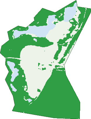
Green: 10 m cells where trees dominate, satellite 2021. Blue: water. The line is the suburb boundary.
| Canopy share, 1 m canopy height map, 2020 | 56.9% |
|---|---|
| Land with trees, 10 m satellite map, 2021 | 69.5% |
Demographics
Population by age in Larapinta
| 0-4 | 3 |
|---|---|
| 5-14 | 0 |
| 15-19 | 0 |
| 20-24 | 0 |
| 25-34 | 0 |
| 35-44 | 0 |
| 45-54 | 3 |
| 55-64 | 0 |
| 65-74 | 0 |
| 75-84 | 0 |
| 85+ | 0 |
Top ancestries in Larapinta
| Ancestry NS | 3 |
|---|---|
| Australian | 0 |
| Aboriginal | 0 |
| Chinese | 0 |
| Croatian | 0 |
| Dutch | 0 |
Birds & Wildlife Nearby
31,146 bird observations recorded near Larapinta — most often seen:
- Torresian Crow (1,732)
- Rainbow Lorikeet (1,679)
- Noisy Miner (1,449)
- Pacific Black Duck (1,404)
- Australian Magpie (1,285)
- Dusky Moorhen (1,257)
- Brown Honeyeater (1,171)
- Australasian Purple Swamphen (1,116)
- Superb Fairy-wren (1,058)
- Laughing Kookaburra (1,023)
- Australian White Ibis (1,009)
- Magpie-lark (998)
- Little Black Cormorant (989)
Show all 30 birds recorded near Larapinta
- Black-faced Cuckoo-shrike (983)
- Pied Currawong (981)
- Striated Pardalote (978)
- Willie Wagtail (971)
- Australasian Darter (940)
- Scaly-breasted Lorikeet (933)
- Little Pied Cormorant (919)
- Pied Butcherbird (870)
- Noisy Friarbird (865)
- Sulphur-crested Cockatoo (859)
- Common Myna (849)
- Welcome Swallow (842)
- Australian Wood Duck (835)
- Lewin's Honeyeater (823)
- Silvereye (798)
- Red-backed Fairy-wren (775)
- Grey Butcherbird (755)
Sightings reported by observers, not a survey, so the counts show what people record rather than what lives here. Source: Atlas of Living Australia.
Nearby Suburbs
The closest suburbs to Larapinta:
- Parkinson (2.2 km)
- Pallara (2.5 km)
- Forestdale (2.6 km)
- Heathwood (2.6 km)
- Hillcrest (3.4 km)
- Algester (3.9 km)
- Doolandella (4.1 km)
- Calamvale (4.2 km)
Embed this suburb
Add this free Larapinta stat card to your own site — just copy the code:
Preview:
Cite this page
Quoting these figures? Copy the credit line:
Keep an eye on Larapinta
One email when this data meaningfully changes — new census figures, prices, rankings. No spam, unsubscribe anytime.
Streets
- Arc Place (6)
- Axis Place (18)
- Commerce Place (8)
- Distribution Street (9)
- Johnson Road (5)
- Logistics Place (10)
- Paradise Road (34)
- Radius Drive (11)