Heathwood QLD 4110
2,087 addresses · 87 streets
Oxley Electorate › Brisbane LGA › Heathwood · 18 km from Brisbane
📦 Thinking of moving here? Read the Heathwood moving guide

Living Here
Heathwood is a suburb of Queensland, home to about 4,944 people, with a median age of 32. The typical household earns around $2,527 a week, with median rent near $455 a week. Most homes are houses. About 75% of households own their home and 25% rent. Most workers drive to work. Common community backgrounds include Indian, English, Australian. On the ABS socio-economic scale it sits in decile 9 of 10 nationally — a relatively advantaged area.
Over time — Census 2001 → 2021
Dashed line: district figures for the Pallara - Willawong statistical area (SA2), the smallest area the ABS published before 2011. Solid line: Heathwood itself.
Getting Around & Local Services
5 cafés & restaurants
4 supermarkets
1 medical clinic
4 childcare & kindergartens
1 library
1 post office
4 service stations
2 bakeries
1 butcher
1 hardware store
2 electricians
2 plumbers
2 carpenters
Getting around. Train station: Richlands, 5.6 km north-west · Bus interchange: Springfield, 9.6 km south-west · Airport: Brisbane Airport, 31.1 km north-east.
Socio-economic Standing
Deciles from 1 (lowest) to 10 (highest), against all Australian suburbs. The overall figure weighs advantage and disadvantage together; economic resources counts income and housing, and education & jobs counts qualifications and occupation. They often differ. Source: ABS SEIFA 2021.
Tree cover
🌳 Tree canopy: 38.5% share of land under canopy · satellite map, 2020
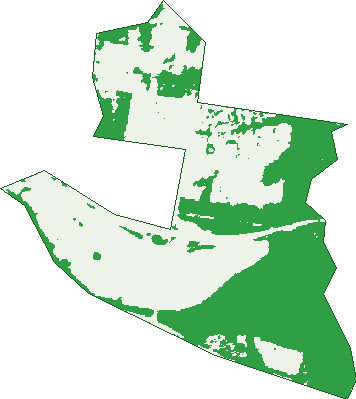
Green: 10 m cells where trees dominate, satellite 2021. Blue: water. The line is the suburb boundary.
| Canopy share, 1 m canopy height map, 2020 | 38.5% |
|---|---|
| Land with trees, 10 m satellite map, 2021 | 46.9% |
Demographics
Unemployment 4.9% · Labour-force participation 75.4%
Population by age in Heathwood
| 0-4 | 485 |
|---|---|
| 5-14 | 835 |
| 15-19 | 299 |
| 20-24 | 281 |
| 25-34 | 873 |
| 35-44 | 1,034 |
| 45-54 | 572 |
| 55-64 | 336 |
| 65-74 | 172 |
| 75-84 | 53 |
| 85+ | 6 |
Dwelling types in Heathwood
| House | 1,354 |
|---|---|
| Townhouse | 46 |
| Apartment | 14 |
| Other | 0 |
Households by weekly income in Heathwood
| <$650 | 64 |
|---|---|
| $650-1,499 | 189 |
| $1,500-2,999 | 575 |
| $3,000+ | 494 |
Top ancestries in Heathwood
| Other | 1,343 |
|---|---|
| Indian | 861 |
| English | 851 |
| Australian | 770 |
| Vietnamese | 497 |
| Chinese | 293 |
Housing tenure in Heathwood
| Owned | 152 |
|---|---|
| Mortgage | 885 |
| Rented | 345 |
| Other | 0 |
Cars per household in Heathwood
| 0 | 16 |
|---|---|
| 1 | 300 |
| 2 | 754 |
| 3 | 239 |
| 4+ | 84 |
Commute to work in Heathwood
| Car | 1,717 |
|---|---|
| Train | 30 |
| Bus | 63 |
| Tram/ferry | 0 |
| Walked | 4 |
| Bicycle | 0 |
| Home | 415 |
Top countries of birth in Heathwood
| India | 689 |
|---|---|
| Vietnam | 304 |
| New Zealand | 252 |
| Sri Lanka | 145 |
| China | 98 |
| Nepal | 96 |
Languages used at home in Heathwood
| Vietnamese | 489 |
|---|---|
| Punjabi | 333 |
| Gujarati | 210 |
| Hindi | 169 |
| Malayalam | 151 |
| Mandarin | 148 |
Birds & Wildlife Nearby
28,675 bird observations recorded near Heathwood — most often seen:
- Torresian Crow (1,637)
- Rainbow Lorikeet (1,578)
- Noisy Miner (1,383)
- Australian Magpie (1,184)
- Brown Honeyeater (1,128)
- Pacific Black Duck (1,101)
- Superb Fairy-wren (988)
- Willie Wagtail (983)
- Pied Currawong (957)
- Black-faced Cuckoo-shrike (954)
- Laughing Kookaburra (952)
- Dusky Moorhen (950)
- Striated Pardalote (949)
Show all 30 birds recorded near Heathwood
- Australasian Darter (938)
- Magpie-lark (909)
- Australasian Purple Swamphen (907)
- Little Black Cormorant (907)
- Sulphur-crested Cockatoo (880)
- Pied Butcherbird (852)
- Noisy Friarbird (847)
- Lewin's Honeyeater (826)
- Welcome Swallow (813)
- Silvereye (796)
- Scaly-breasted Lorikeet (794)
- Little Pied Cormorant (781)
- Red-backed Fairy-wren (773)
- Australian White Ibis (755)
- Scarlet Honeyeater (742)
- Bar-shouldered Dove (723)
- Blue-faced Honeyeater (688)
Sightings reported by observers, not a survey, so the counts show what people record rather than what lives here. Source: Atlas of Living Australia.
Nearby Suburbs
The closest suburbs to Heathwood:
- Doolandella (2.2 km)
- Pallara (2.3 km)
- Larapinta (2.6 km)
- Forest Lake (2.6 km)
- Forestdale (4.1 km)
- Ellen Grove (4.3 km)
- Inala (4.3 km)
- Parkinson (4.5 km)
Embed this suburb
Add this free Heathwood stat card to your own site — just copy the code:
Preview:
Cite this page
Quoting these figures? Copy the credit line:
Keep an eye on Heathwood
One email when this data meaningfully changes — new census figures, prices, rankings. No spam, unsubscribe anytime.
Streets
- Acacia Street (24)
- Arlington Street (13)
- Ashendon Close (6)
- Aspen Street (24)
- Balmain Street (7)
- Barrisdale Street (19)
- Beech Street (4)
- Beneton Court (10)
- Bentley Street (42)
- Berkshire Place (122)
- Bignonia Close (10)
- Birch Close (7)
- Blunder Road (2)
- Bottlebrush Street (23)
- Boxwood Close (9)
- Brush Box Place (12)
- Callistemon Street (12)
- Casuarina Circuit (30)
- Charleston Place (24)
- Coolibah Street (21)
- Cypress Street (15)
- Dalcross Place (16)
- Damson Street (4)
- Derby Street (16)
- Domatia Street (16)
- Dominic Place (16)
- Dunvegan Street (28)
- Elliot Street (3)
- Elm Place (11)
- Empress Close (16)
- Eucalyptus Street (6)
- Falkland Street (16)
- Falkland Street E (1)
- Falkland Street W (102)
- Franken Place (28)
- Gardenia Circuit (44)
- Geijera Close (4)
- Glendale Crescent (26)
- Hazel Street (5)
- Hillside Street (25)
- Hub Crescent (27)
- Invergarry Circuit (105)
- Ironbark Place (15)
- Johnson Road (5)
- Juniper Street (50)
- Kent Street (31)
- Kintore Street (18)
- Koala Street (28)
- Kurrajong Street (4)
- Laurel Street (29)
- Lilly Pilly Street (12)
- Madison Street (2)
- Melaleuca Street (7)
- Moreton Street (14)
- Nightcap Close (6)
- Noosa Street (9)
- Oak Street (16)
- Old Blunder Road (5)
- Paperbark Crescent (34)
- Parkwood Drive (60)
- Pinnacle Circuit (54)
- Portree Crescent (51)
- Regal Close (46)
- Rise Place (37)
- Rowan Street (9)
- Sanctuary Drive (7)
- Sandalwood Street (32)
- Seeana Place (4)
- Skyline Street (33)
- Spotted Gum Street (24)
- Stapylton Road (31)
- Steelwood Street (79)
- Stradbroke Street (34)
- Stringybark Place (9)
- Tea Tree Street (12)
- The Avenue (58)
- Toorwood Street (12)
- Trafford Crescent (56)
- Trafford Street (1)
- Ullapool Street (24)
- Vu Street (16)
- Wadeville Street (48)
- Watergum Street (11)
- Wattle Street (4)
- Willow Place (7)
- Wirewood Place (13)
- Yering Street (79)