Doolandella QLD 4077
3,316 addresses · 101 streets
Oxley Electorate › Brisbane LGA › Doolandella · 16 km from Brisbane
📦 Thinking of moving here? Read the Doolandella moving guide

Living Here
Doolandella is a suburb of Queensland, home to about 7,123 people, with a median age of 30. The typical household earns around $1,882 a week, with median rent near $360 a week. Most homes are houses. About 54% of households own their home and 45% rent. Most workers drive to work. Common community backgrounds include English, Australian, Vietnamese. On the ABS socio-economic scale it sits in decile 4 of 10 nationally — a mid-range area.
Over time — Census 2001 → 2021
Dashed line: district figures for the Forest Lake - Doolandella statistical area (SA2), the smallest area the ABS published before 2011. Solid line: Doolandella itself.
Getting Around & Local Services
2 pharmacies
5 doctors & medical clinics
2 dentists
1 library
1 post office
4 gyms & sports centres
1 butcher
1 hairdresser
2 electricians
2 plumbers
Getting around. Train station: Richlands, 4 km north-west · Bus interchange: Mount Ommaney, 8.4 km north-west · Airport: Brisbane Airport, 29.3 km north-east.
Socio-economic Standing
Deciles from 1 (lowest) to 10 (highest), against all Australian suburbs. The overall figure weighs advantage and disadvantage together; economic resources counts income and housing, and education & jobs counts qualifications and occupation. They often differ. Source: ABS SEIFA 2021.
Tree cover
🌳 Tree canopy: 41.8% share of land under canopy · satellite map, 2020
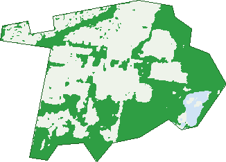
Green: 10 m cells where trees dominate, satellite 2021. Blue: water. The line is the suburb boundary.
| Canopy share, 1 m canopy height map, 2020 | 41.8% |
|---|---|
| Land with trees, 10 m satellite map, 2021 | 49.8% |
Demographics
Unemployment 6.6% · Labour-force participation 70%
Population by age in Doolandella
| 0-4 | 705 |
|---|---|
| 5-14 | 1,089 |
| 15-19 | 441 |
| 20-24 | 607 |
| 25-34 | 1,380 |
| 35-44 | 1,158 |
| 45-54 | 782 |
| 55-64 | 551 |
| 65-74 | 303 |
| 75-84 | 86 |
| 85+ | 25 |
Dwelling types in Doolandella
| House | 1,569 |
|---|---|
| Townhouse | 566 |
| Apartment | 9 |
| Other | 0 |
Households by weekly income in Doolandella
| <$650 | 163 |
|---|---|
| $650-1,499 | 593 |
| $1,500-2,999 | 875 |
| $3,000+ | 384 |
Top ancestries in Doolandella
| Other | 2,141 |
|---|---|
| English | 1,249 |
| Australian | 1,199 |
| Vietnamese | 1,027 |
| Indian | 557 |
| Ancestry NS | 528 |
Housing tenure in Doolandella
| Owned | 283 |
|---|---|
| Mortgage | 860 |
| Rented | 952 |
| Other | 21 |
Cars per household in Doolandella
| 0 | 42 |
|---|---|
| 1 | 644 |
| 2 | 984 |
| 3 | 322 |
| 4+ | 142 |
Commute to work in Doolandella
| Car | 2,526 |
|---|---|
| Train | 69 |
| Bus | 45 |
| Tram/ferry | 0 |
| Walked | 11 |
| Bicycle | 0 |
| Home | 334 |
Top countries of birth in Doolandella
| Vietnam | 697 |
|---|---|
| India | 516 |
| New Zealand | 398 |
| Philippines | 127 |
| Fiji | 115 |
| Samoa | 88 |
Languages used at home in Doolandella
| Vietnamese | 1,069 |
|---|---|
| Punjabi | 285 |
| Samoan | 197 |
| Hindi | 164 |
| Mandarin | 157 |
| Arabic | 131 |
Birds & Wildlife Nearby
54,981 bird observations recorded near Doolandella — most often seen:
- Torresian Crow (2,868)
- Rainbow Lorikeet (2,773)
- Noisy Miner (2,535)
- Brown Honeyeater (2,255)
- Willie Wagtail (2,250)
- Australian Magpie (2,229)
- Pacific Black Duck (2,154)
- Australian White Ibis (2,149)
- Superb Fairy-wren (2,080)
- Australasian Purple Swamphen (2,058)
- Laughing Kookaburra (2,051)
- Black-faced Cuckoo-shrike (1,933)
- Red-backed Fairy-wren (1,784)
Show all 30 birds recorded near Doolandella
- Welcome Swallow (1,723)
- Scaly-breasted Lorikeet (1,693)
- Sulphur-crested Cockatoo (1,692)
- Dusky Moorhen (1,674)
- Lewin's Honeyeater (1,664)
- Tawny Grassbird (1,635)
- Striated Pardalote (1,630)
- Magpie-lark (1,554)
- Pied Butcherbird (1,546)
- Pied Currawong (1,546)
- Grey Butcherbird (1,417)
- Rainbow Bee-eater (1,409)
- Silvereye (1,405)
- Red-browed Finch (1,396)
- Australasian Figbird (1,316)
- Blue-faced Honeyeater (1,290)
- Australasian Darter (1,272)
Sightings reported by observers, not a survey, so the counts show what people record rather than what lives here. Source: Atlas of Living Australia.
Nearby Suburbs
The closest suburbs to Doolandella:
- Forest Lake (2.1 km)
- Heathwood (2.2 km)
- Pallara (2.2 km)
- Inala (2.2 km)
- Durack (2.7 km)
- Richlands (3.5 km)
- Willawong (3.7 km)
- Ellen Grove (3.8 km)
Embed this suburb
Add this free Doolandella stat card to your own site — just copy the code:
Preview:
Cite this page
Quoting these figures? Copy the credit line:
Keep an eye on Doolandella
One email when this data meaningfully changes — new census figures, prices, rankings. No spam, unsubscribe anytime.
Streets
- Agostino Close (19)
- Albert Street (12)
- Anesbury Street (50)
- Armisfield Street (64)
- Avington Street (24)
- Bandicoot Crescent (21)
- Beccaria Place (23)
- Benier Close (10)
- Bettong Place (12)
- Bi Em Street (3)
- Bilby Place (17)
- Blunder Road (65)
- Blythdale Place (22)
- Boodie Close (10)
- Bowerbird Close (9)
- Brookside Street (16)
- Brushtail Crescent (39)
- Cassowary Street (52)
- Cloverdale Road (158)
- Colebrook Crescent (44)
- Cromwell Court (53)
- Crossacres Street (69)
- Currawong Street (46)
- Daisy Place (17)
- Dasheng Street (63)
- Davidshone Close (10)
- Echidna Close (11)
- Elphinstone Street (46)
- Emu Place (27)
- Ewingsdale Street (17)
- Falso Place (115)
- Fred Pham Crescent (55)
- Gecko Place (19)
- Giancarlo Crescent (52)
- Gibbston Place (18)
- Gladys Street (22)
- Glider Close (10)
- Grandly Street (74)
- Grove Street (2)
- Hammersmith Crescent (30)
- Hanley Place (10)
- Hawkden Close (4)
- Heysen Close (7)
- Hillingdon Street (17)
- Hillington Street (17)
- Joseph Banks Avenue (2)
- Karrabul Crescent (9)
- Kittel Court (5)
- Kokuso Place (109)
- Kookaburra Place (20)
- Leonie Place (28)
- Luther James Close (46)
- Lyrebird Close (10)
- Mayfair Street (66)
- Moralana Close (15)
- Muhammad Street (24)
- Naltar Street (5)
- Northampton Crescent (19)
- Numbat Place (12)
- Nunderi Crescent (27)
- Owl Street (1)
- Paddington Street (57)
- Panda Street (160)
- Peacock Street (12)
- Penderyn Street (4)
- Penglase Place (12)
- Pentonville Street (18)
- Perregreen Street (29)
- Philong Street (120)
- Platypus Court (7)
- Possum Court (5)
- Potoroo Place (18)
- Quoll Court (7)
- Rainworth Place (23)
- Redhead Street (153)
- Ringtail Close (12)
- Rockfield Road (161)
- Rothburn Street (48)
- Saint Marys Close (30)
- Sallyanne Street (15)
- Sevenhill Place (27)
- Sophie Place (128)
- Sulphur Crest Close (12)
- Sunny Street (15)
- Tammar Close (9)
- Tomaso Close (14)
- Twins Court (8)
- Van Asch Close (17)
- Wallaby Court (6)
- Wallaroo Way (98)
- Warrigal Court (3)
- Wedgetail Street (1)
- Westminister Boulevard (46)
- Westminster Boulevard (66)
- Whipbird Place (15)
- William Close (15)
- Wimbledon Close (11)
- Wombat Place (18)
- Woodland Avenue (3)
- Zahd Lane (17)
- Zahid Close (17)